Click on an image for detailed information
Click on a column heading to sort in ascending or descending order

My
List |
Addition Date
|
Target
|
Mission
|
Instrument
|
Size
|

|
2007-10-05 |
Mars
|
Mars Reconnaissance Orbiter (MRO)
|
|
1683x2502x3 |
|
-
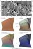
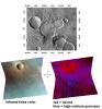
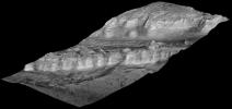
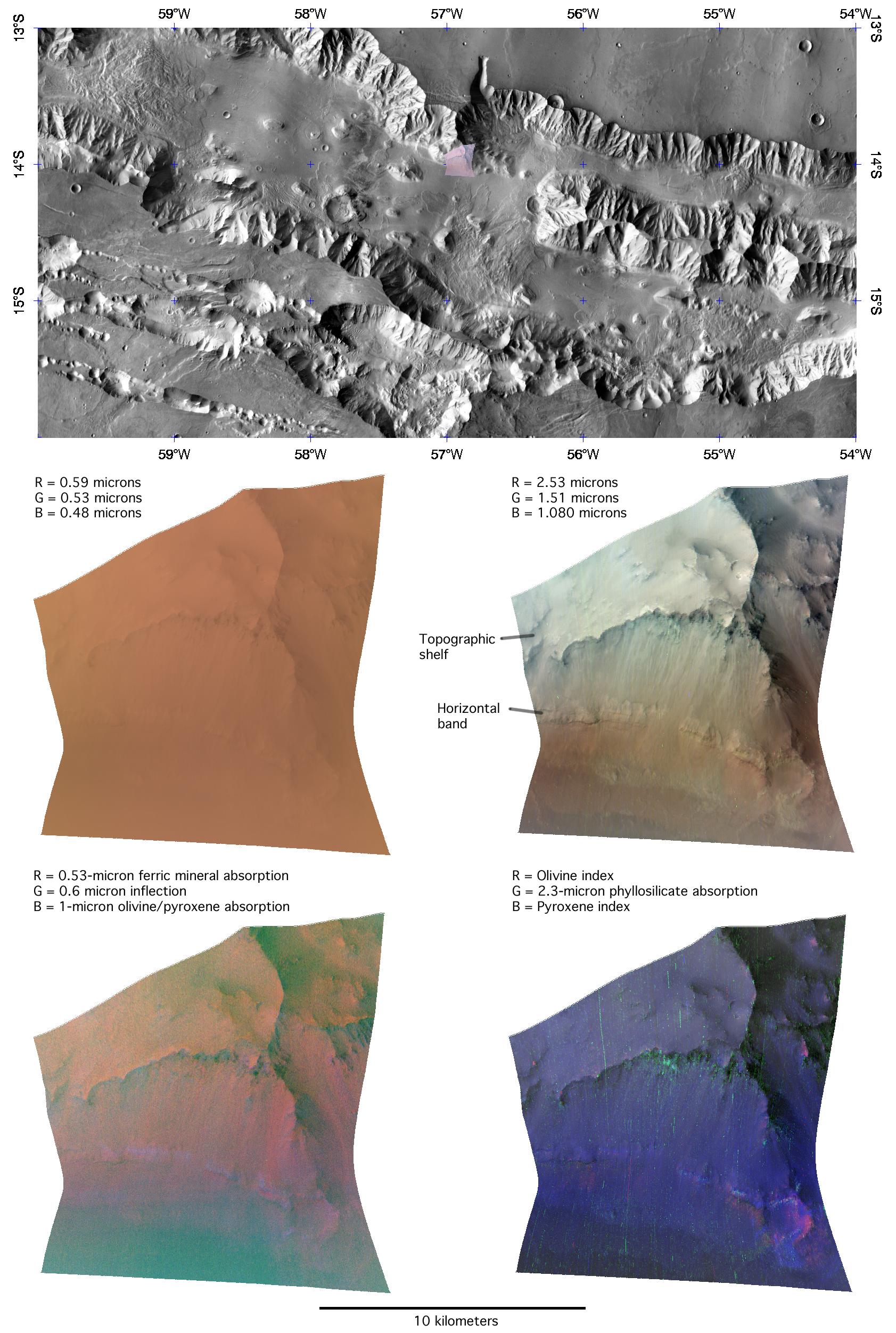
PIA10074:
-
The Layer Cake Walls of Valles Marineris
Full Resolution:
TIFF
(12.65 MB)
JPEG
(500.5 kB)
|
|
|
2009-09-24 |
Mars
|
Mars Reconnaissance Orbiter (MRO)
|
|
1375x810x3 |
|
-
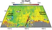
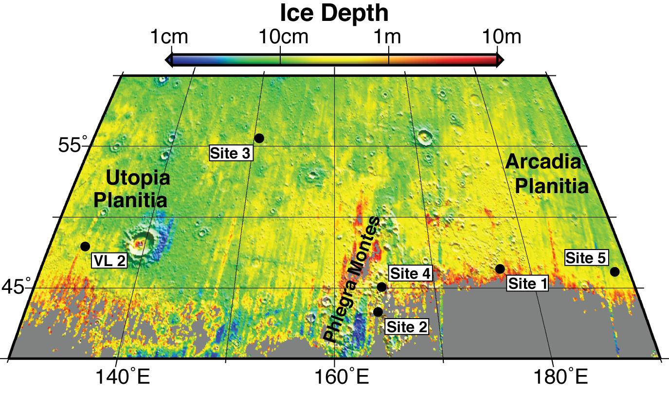
PIA12214:
-
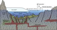
Expected Depths to Ice, Mid-Latitude Northern Mars
Full Resolution:
TIFF
(3.348 MB)
JPEG
(198.8 kB)
|
|
|
2012-08-04 |
Mars
|
Mars Reconnaissance Orbiter (MRO)
Mars Science Laboratory (MSL)
|
|
1051x727x3 |
|
-
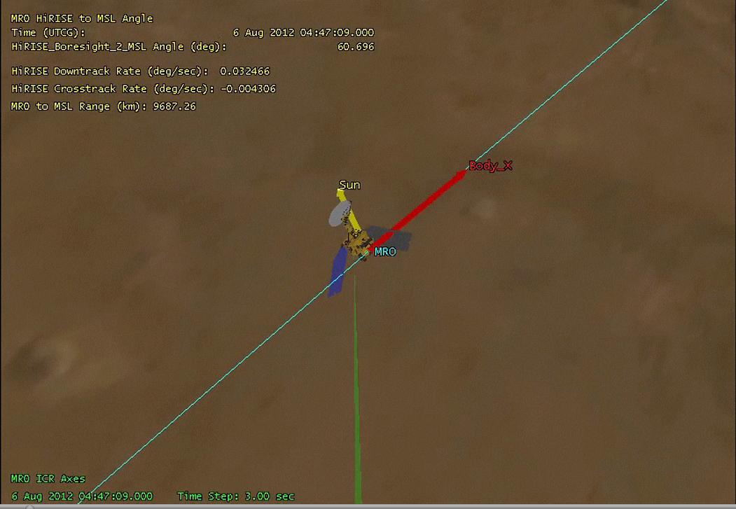
PIA15964:
-
Mars Reconnaissance Orbiter Flying Over Mars

Full Resolution:
TIFF
(2.293 MB)
JPEG
(68.13 kB)
|
|
|
2017-10-06 |
Mars
|
Mars Reconnaissance Orbiter (MRO)
|
|
1032x641x3 |
|
-
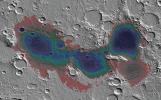
PIA22059:
-
Estimated Water Depths in Ancient Martian Sea
Full Resolution:
TIFF
(1.743 MB)
JPEG
(154.7 kB)
|
|
|
2017-10-06 |
Mars
|
Mars Reconnaissance Orbiter (MRO)
|
|
788x416x3 |
|
-
PIA22060:
-
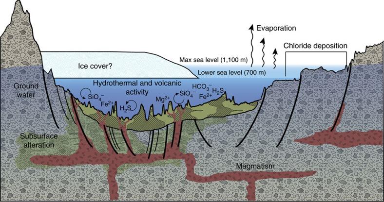
A Geologic Model for Eridania Basin on Ancient Mars
Full Resolution:
TIFF
(694.9 kB)
JPEG
(76.72 kB)
|
|
|
2003-09-25 |
Mars
|
Mars Reconnaissance Orbiter (MRO)
|
|
3201x2921x3 |
|
-
PIA04758:
-
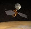
Artist's Concept of Mars Reconnaissance Orbiter
Full Resolution:
TIFF
(15.99 MB)
JPEG
(856.5 kB)
|
|
|
2010-12-16 |
Mars
|
Mars Express (MEX)
Mars Global Surveyor (MGS)
Mars Reconnaissance Orbiter (MRO)
|
Altimeter
CRISM
Visible and Infrared Mineralogical Mapping Spectrometer
|
2999x1515x3 |
|
-
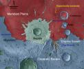
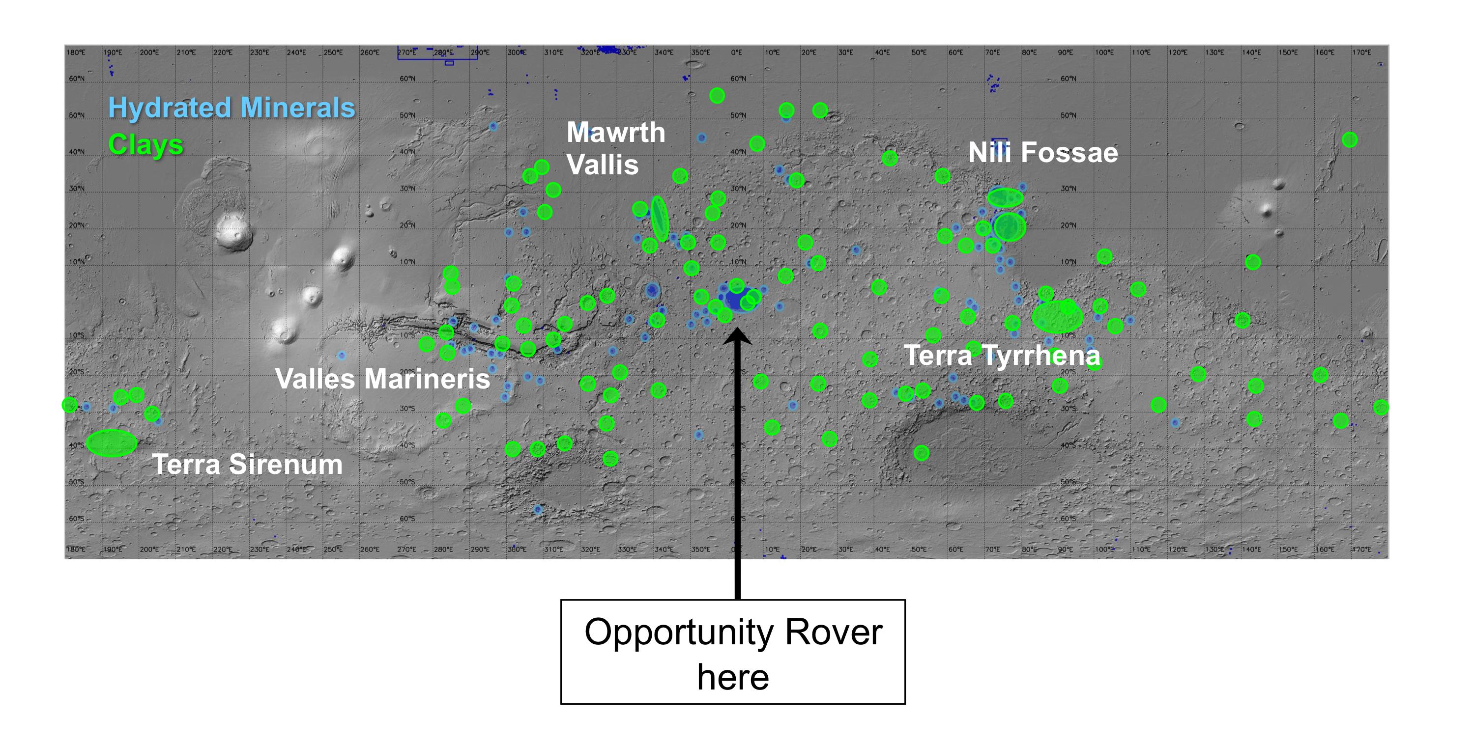
PIA13703:
-
Regions of Mars with Clays and Hydrated Minerals Identified from Orbit
Full Resolution:
TIFF
(13.63 MB)
JPEG
(581.5 kB)
|
|
|
2016-12-13 |
Mars
|
Mars Reconnaissance Orbiter (MRO)
Mars Science Laboratory (MSL)
|
ChemCam
HiRISE
|
2809x2025x3 |
|
-
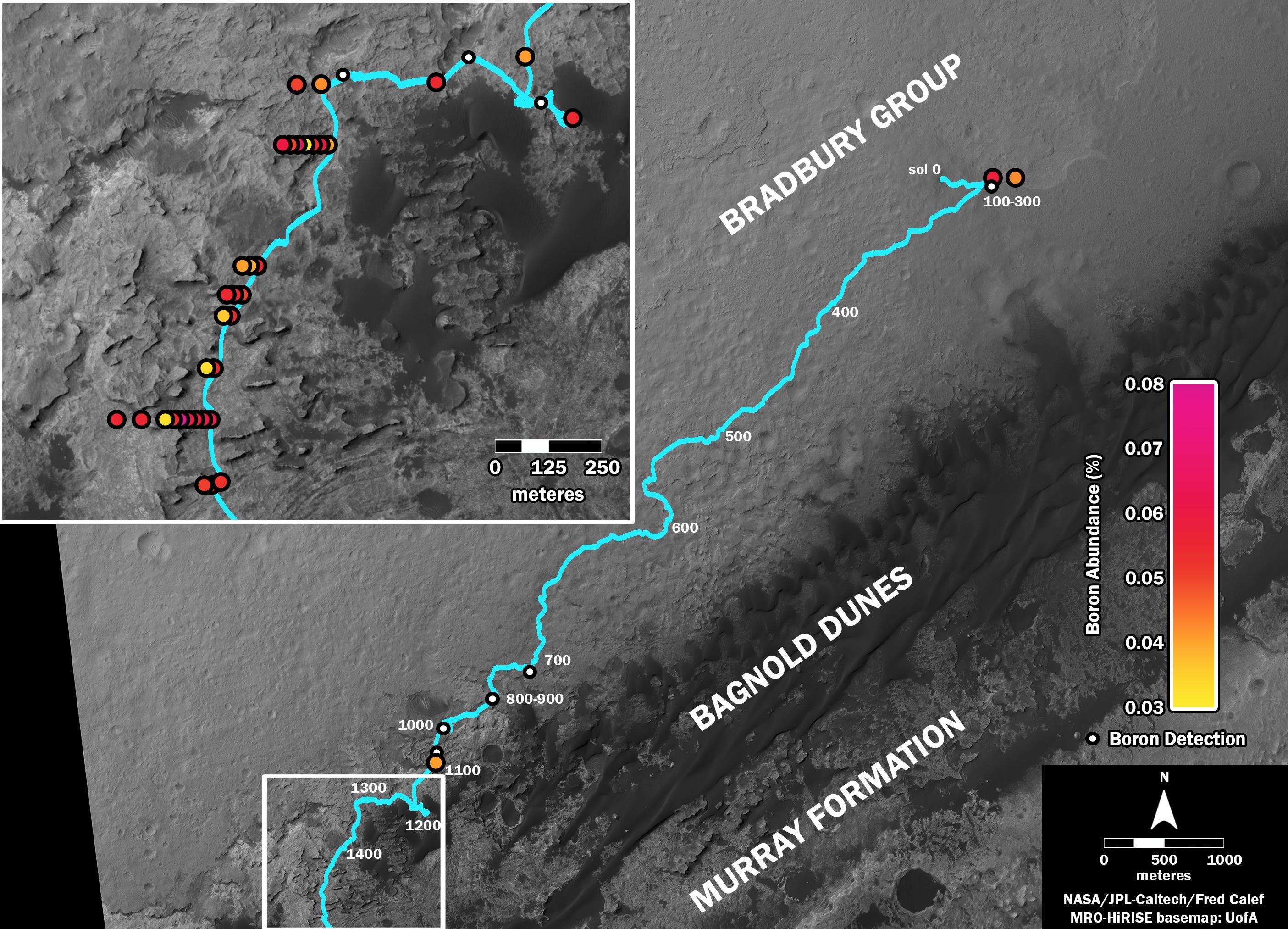
PIA21150:
-
Where's Boron? Mars Rover Detects It
Full Resolution:
TIFF
(7.738 MB)
JPEG
(838.4 kB)
|
|
|
2006-09-29 |
Mars
|
Mars Reconnaissance Orbiter (MRO)
|
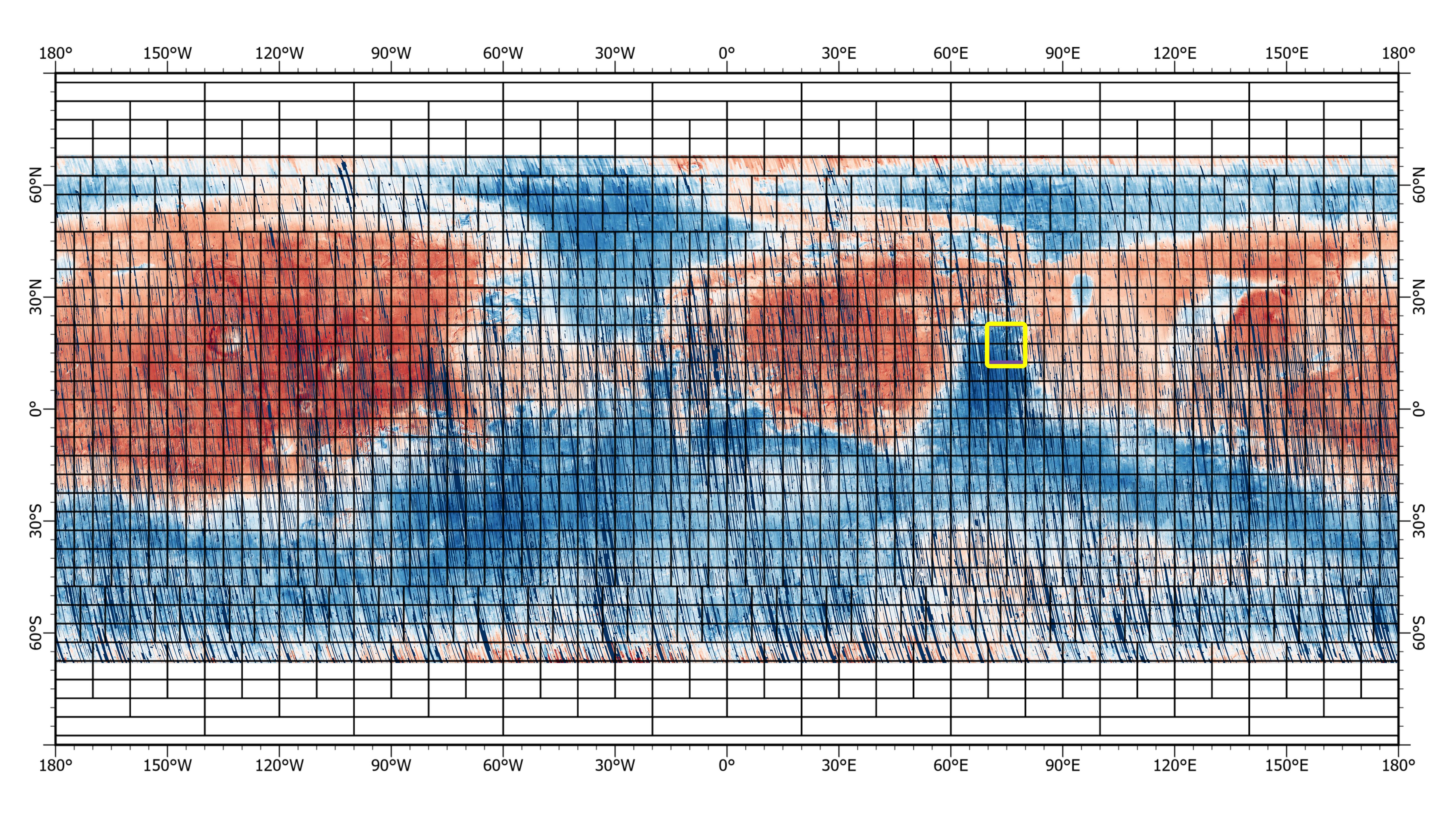
CRISM
|
192x2700x3 |

|
-
PIA08788:
-
New Spectrometer Begins its Global Map of Mars
Full Resolution:
TIFF
(946.5 kB)
JPEG
(84.73 kB)
|
|
|
2006-10-16 |
Mars
|
Mars Reconnaissance Orbiter (MRO)
|
CRISM
|
1044x1340x3 |
|
-
PIA01922:
-
Chasma Boreale in the North Polar Region
Full Resolution:
TIFF
(4.202 MB)
JPEG
(79.27 kB)
|
|
|
2006-10-16 |
Mars
|
Mars Reconnaissance Orbiter (MRO)
|
CRISM
|
1550x2131x3 |
|
-
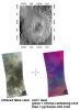
PIA01927:
-
Spectrometer Observations Near Mawrth Vallis
Full Resolution:
TIFF
(9.926 MB)
JPEG
(364.1 kB)
|
|
|
2006-12-13 |
Mars
|
Mars Reconnaissance Orbiter (MRO)
|
CRISM
|
1110x996x3 |
|
-
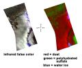
PIA09094:
-
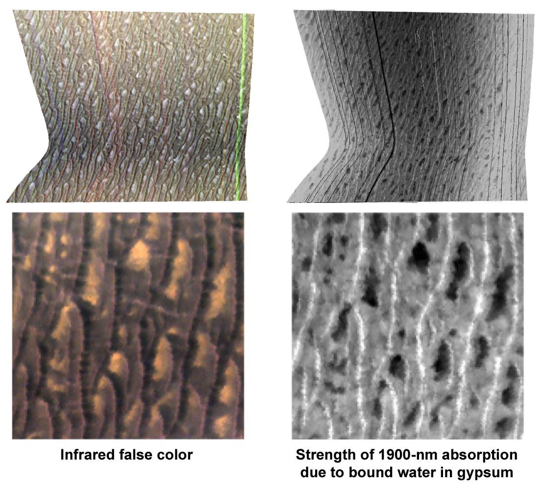
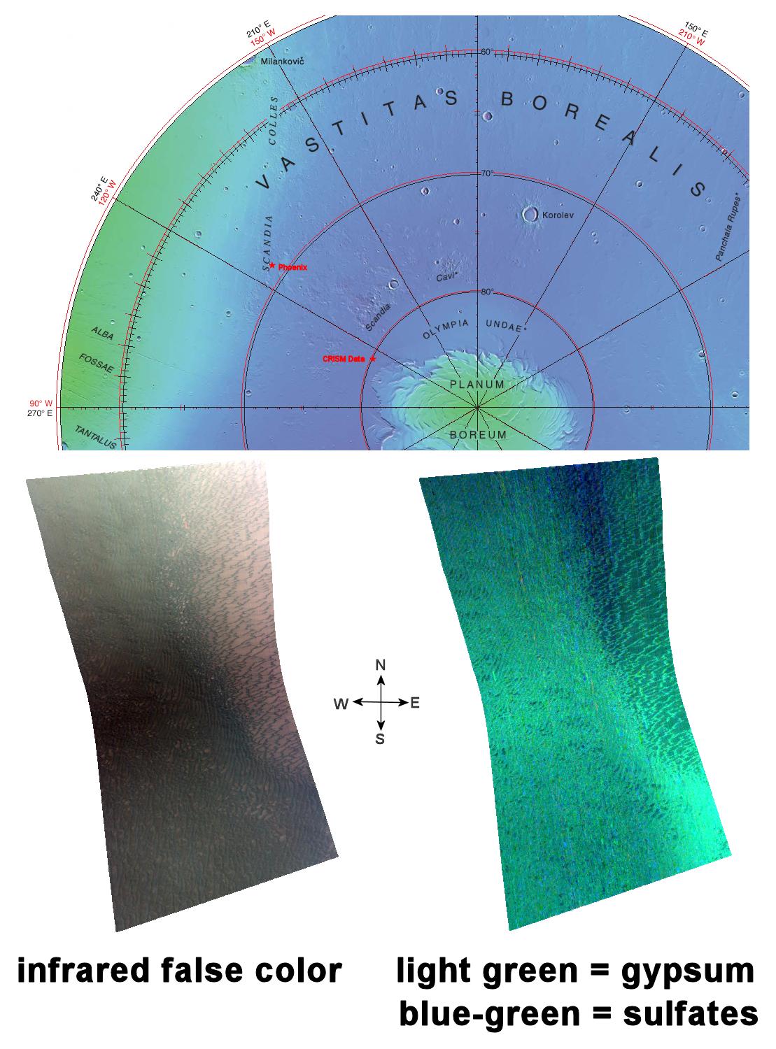
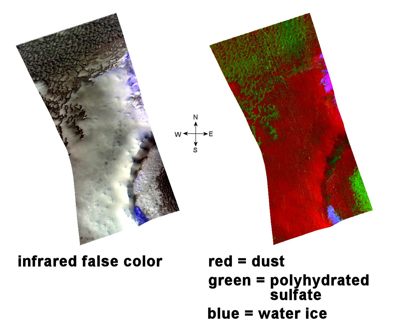
Gypsum at Olympia Undae
Full Resolution:
TIFF
(3.321 MB)
JPEG
(163.7 kB)
|
|
|
2006-12-22 |
Mars
|
Mars Reconnaissance Orbiter (MRO)
|
CRISM
|
1728x1728x3 |
|
-
PIA09101:
-
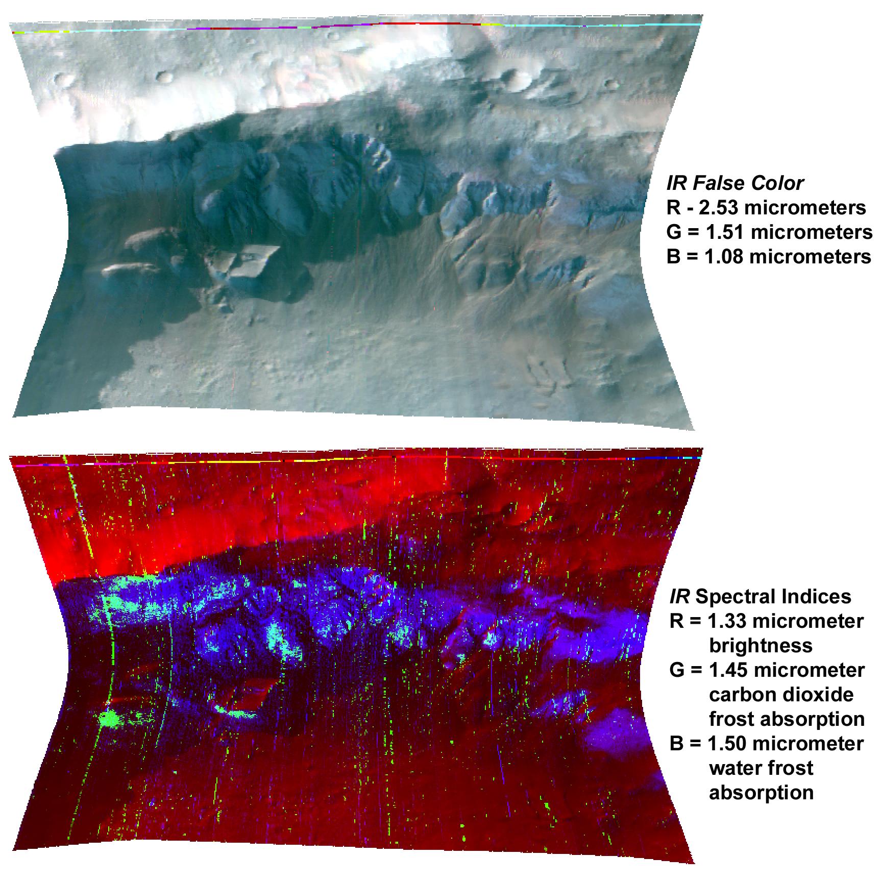
Seasonal Frost in Terra Sirenum
Full Resolution:
TIFF
(8.972 MB)
JPEG
(367.2 kB)
|
|
|
2007-02-13 |
Mars
|
Mars Reconnaissance Orbiter (MRO)
|
CRISM
|
758x1550x3 |
|
-
PIA09195:
-
A Fresh Crater Drills to Tharsis Bedrock
Full Resolution:
TIFF
(3.529 MB)
JPEG
(92.81 kB)
|
|
|
2007-02-15 |
Mars
|
Mars Reconnaissance Orbiter (MRO)
|
CRISM
|
3000x3000x3 |
|
-
PIA09346:
-
A Change in the Weather
Full Resolution:
TIFF
(27 MB)
JPEG
(878.4 kB)
|
|
|
2006-10-04 |
Mars
|
Mars Reconnaissance Orbiter (MRO)
|
CRISM
|
1584x978x3 |
|
-
PIA09343:
-
CRISM's First 'Targeted' Observation of Mars
Full Resolution:
TIFF
(4.656 MB)
JPEG
(162 kB)
|
|
|
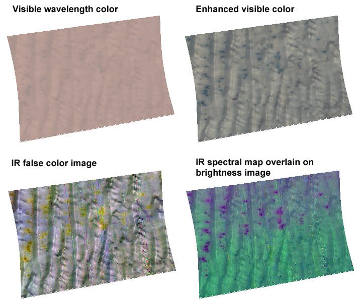
2007-02-21 |
Mars
|
Mars Reconnaissance Orbiter (MRO)
|
CRISM
|
684x1277x3 |
|
-
PIA09347:
-
Dune Field in Nili Pateria
Full Resolution:
TIFF
(2.624 MB)
JPEG
(127.6 kB)
|
|
|
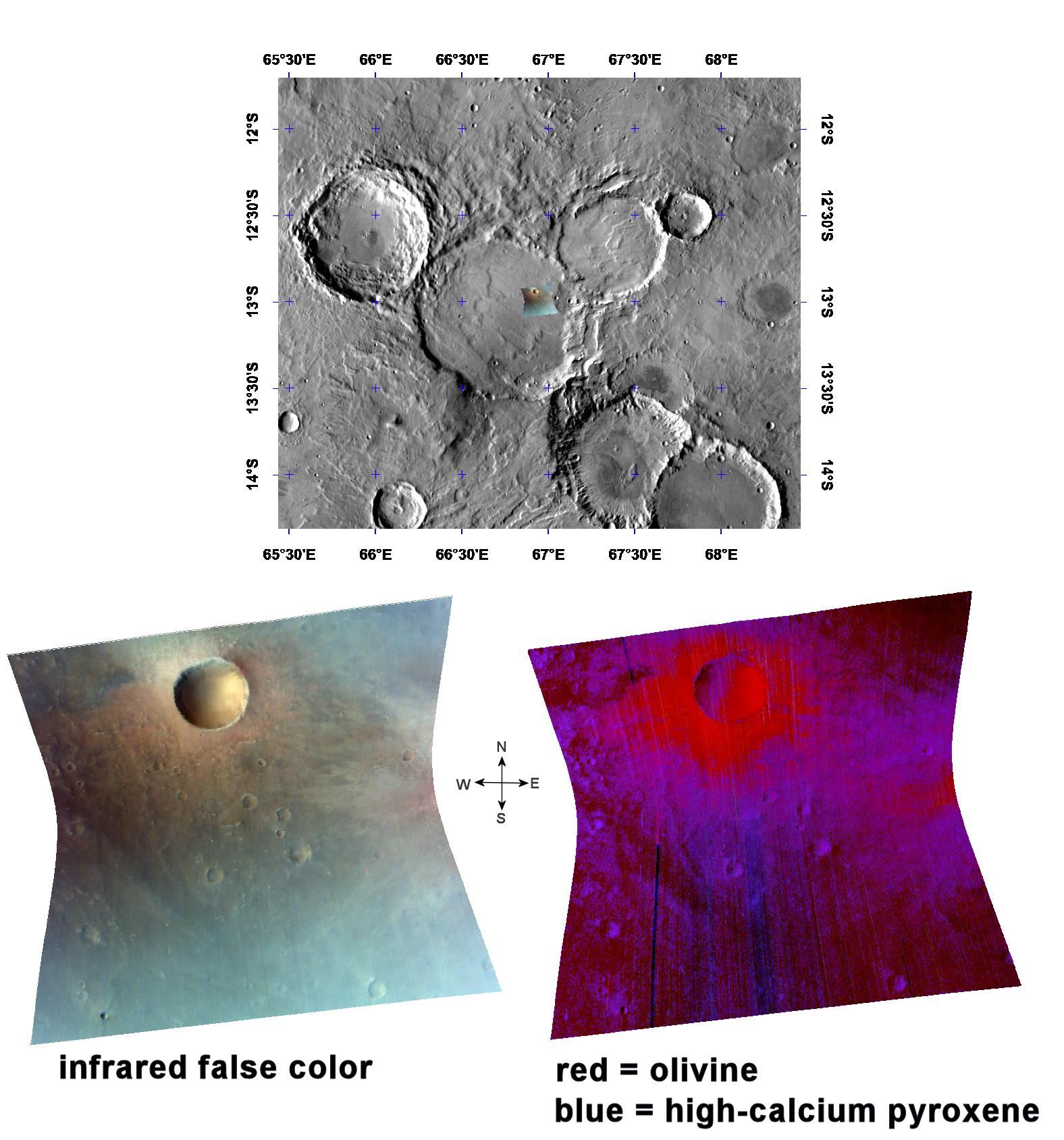
2007-02-23 |
Mars
|
Mars Reconnaissance Orbiter (MRO)
|
CRISM
|
1363x651x3 |

|
-
PIA09348:
-
Olivine in the Southern Isidis Basin
Full Resolution:
TIFF
(2.665 MB)
JPEG
(120.7 kB)
|
|
|
2007-02-27 |
Mars
|
Mars Reconnaissance Orbiter (MRO)
|
CRISM
|
708x596x3 |
|
-
PIA09349:
-
A Cold Day in Richardson Crater
Full Resolution:
TIFF
(1.268 MB)
JPEG
(59.4 kB)
|
|
|
2007-03-16 |
Mars
|
Mars Reconnaissance Orbiter (MRO)
|
CRISM
|
1203x680x3 |
|
-
PIA09350:
-
South Polar Cryptic Terrain in Early Spring
Full Resolution:
TIFF
(2.457 MB)
JPEG
(91.08 kB)
|
|
|
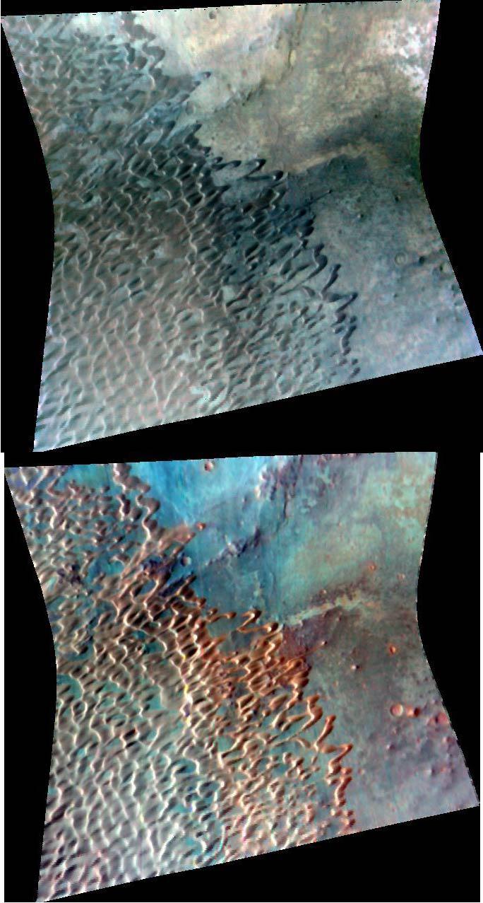
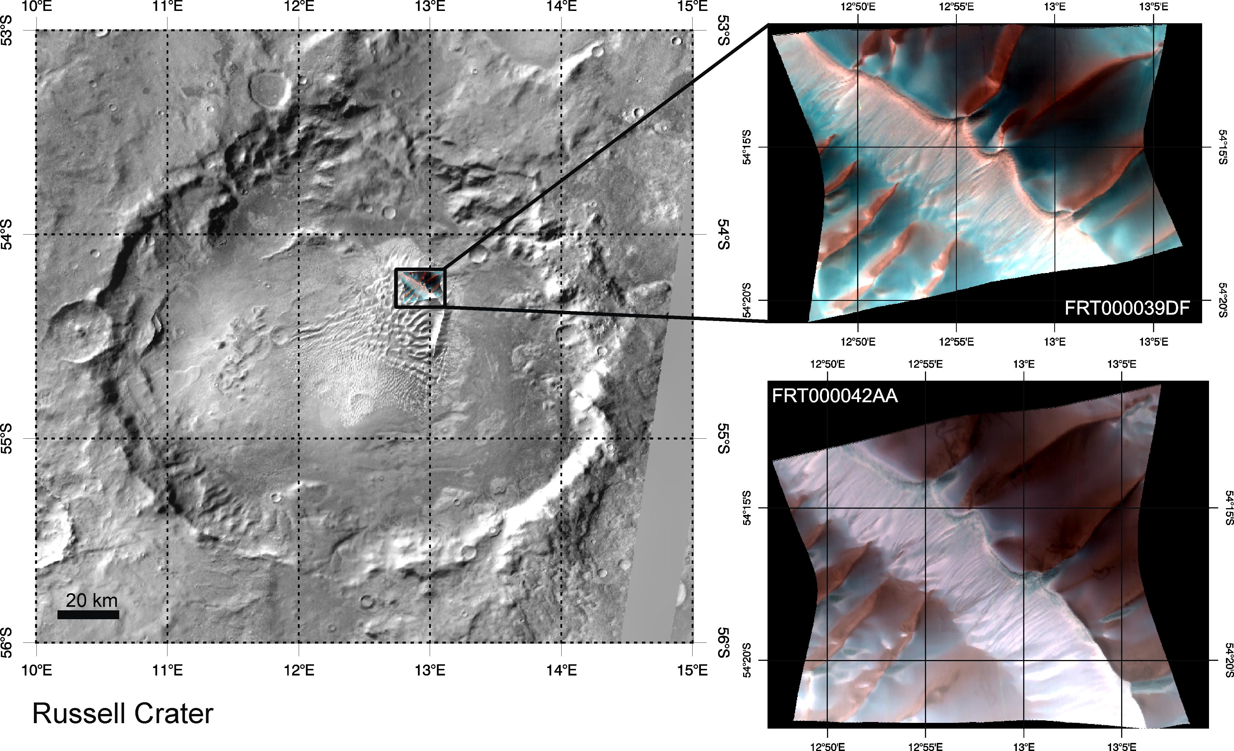
2007-03-27 |
Mars
|
Mars Reconnaissance Orbiter (MRO)
|
CRISM
|
4296x2616x3 |
|
-
PIA09351:
-
Defrosting of Russell Crater Dunes
Full Resolution:
TIFF
(33.72 MB)
JPEG
(1.188 MB)
|
|
|
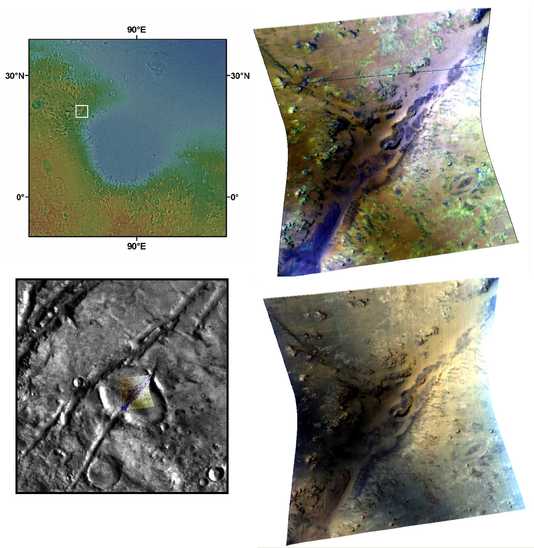
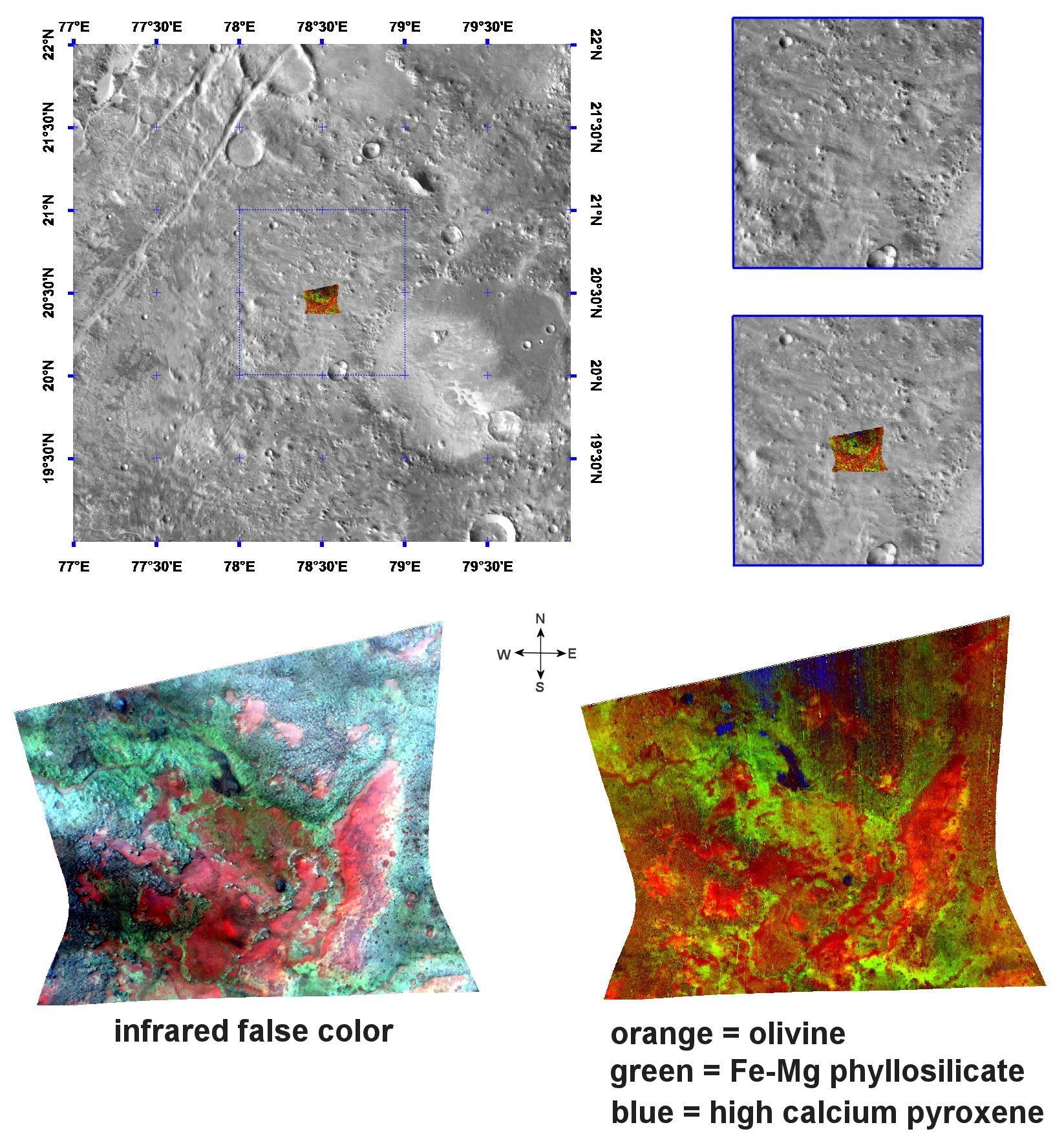
2007-05-18 |
Mars
|
Mars Reconnaissance Orbiter (MRO)
|
CRISM
|
1794x1839x3 |

|
-
PIA09933:
-
Phyllosilicate and Olivine around a Fracture in Nili Fossae
Full Resolution:
TIFF
(9.912 MB)
JPEG
(390 kB)
|
|
|
2007-06-11 |
Mars
|
Mars Reconnaissance Orbiter (MRO)
|
CRISM
|
1427x883x3 |
|
-
PIA09934:
-
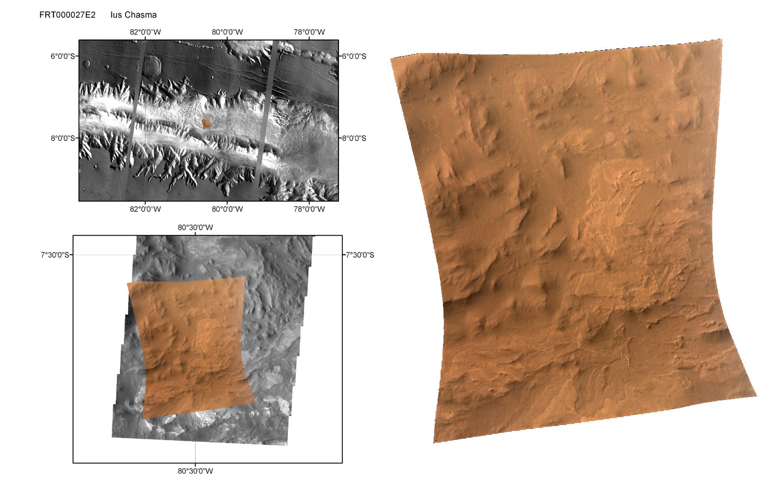
CRISM Mulitspectral Map of Eastern Candor Chasma
Full Resolution:
TIFF
(3.787 MB)
JPEG
(269.7 kB)
|
|
|
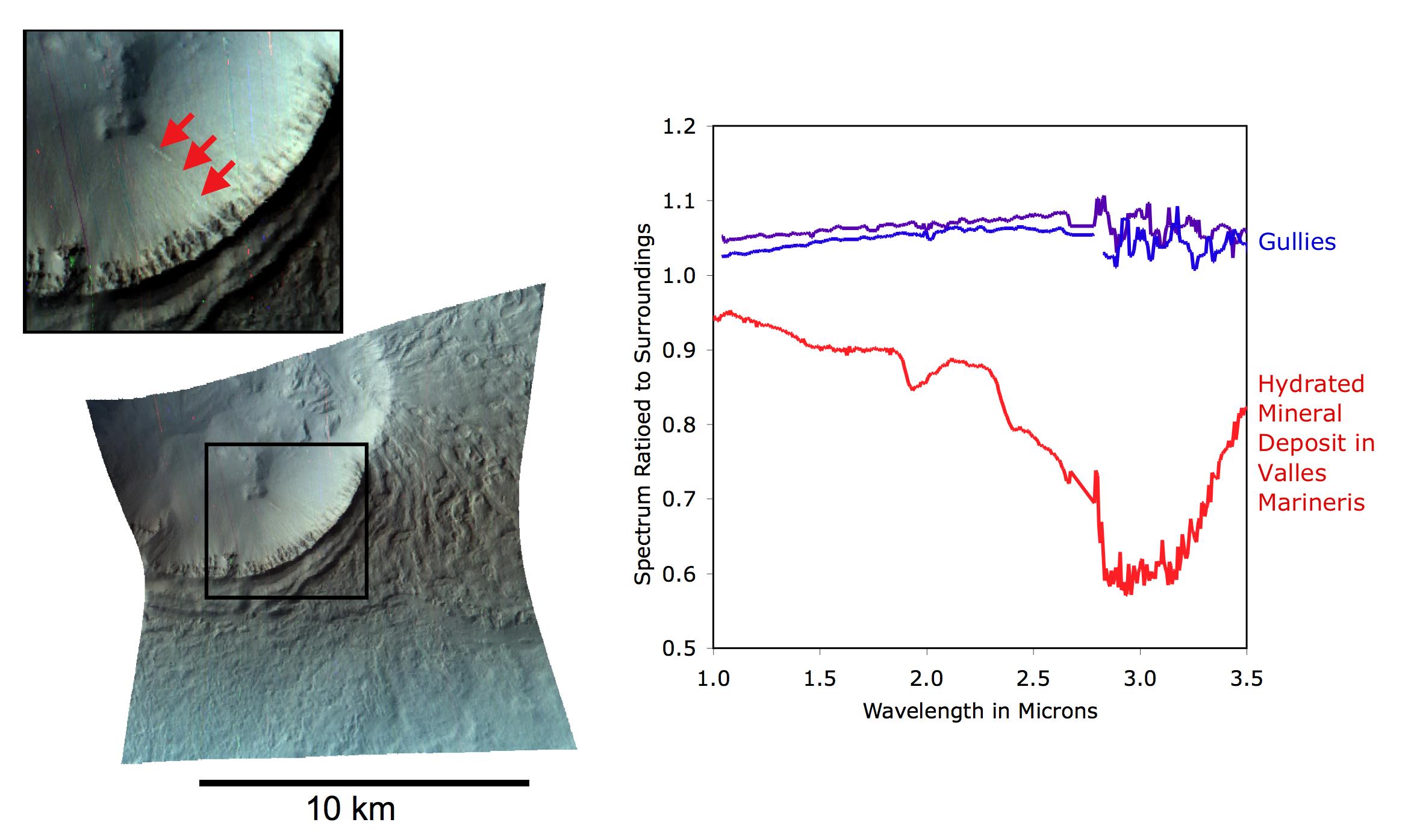
2007-09-24 |
Mars
|
Mars Reconnaissance Orbiter (MRO)
|
CRISM
|
2358x1395x3 |
|
-
PIA10005:
-
Mars Gully: No Mineral Trace of Liquid Water
Full Resolution:
TIFF
(9.88 MB)
JPEG
(226.6 kB)
|
|
|
2007-09-11 |
Mars
|
Mars Reconnaissance Orbiter (MRO)
|
CRISM
|
1448x1550x3 |
|
-
PIA10073:
-
Nili Fossae in Natural Color and Across the Spectrum
Full Resolution:
TIFF
(6.746 MB)
JPEG
(298.6 kB)
|
|
|
2007-10-19 |
Mars
|
Mars Reconnaissance Orbiter (MRO)
|
CRISM
|
2400x2400x3 |
|
-
PIA10085:
-
Spectrometer Images of Candidate Landing Sites for Next Mars Rover
Full Resolution:
TIFF
(17.3 MB)
JPEG
(545.7 kB)
|
|
|
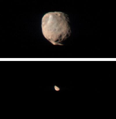
2007-11-27 |
Mars
|
Mars Reconnaissance Orbiter (MRO)
|
CRISM
|
400x410x3 |

|
-
PIA10117:
-
CRISM Views Phobos and Deimos
Full Resolution:
TIFF
(492.8 kB)
JPEG
(6.418 kB)
|
|
|
2007-12-11 |
Mars
|
Mars Reconnaissance Orbiter (MRO)
|
CRISM
|
720x486x3 |
|
-
PIA10137:
-
Carbon-Dioxide Frost Settling from Seasonal Outbursts on Mars (Movie)
Full Resolution:
TIFF
(1.051 MB)
JPEG
(28.16 kB)
|
|
|
2007-12-12 |
Mars
|
Mars Reconnaissance Orbiter (MRO)
|
CRISM
|
1350x1380x3 |
|
-
PIA10203:
-
CRISM's Global Mapping of Mars, Part 3
Full Resolution:
TIFF
(5.595 MB)
JPEG
(425.2 kB)
|
|
|
2007-12-07 |
Mars
|
Mars Reconnaissance Orbiter (MRO)
|
CRISM
|
1350x1380x3 |
|
-
PIA10201:
-
CRISM's Global Mapping of Mars, Part 1
Full Resolution:
TIFF
(5.595 MB)
JPEG
(366.8 kB)
|
|
|
2007-12-10 |
Mars
|
Mars Reconnaissance Orbiter (MRO)
|
CRISM
|
1350x1380x3 |
|
-
PIA10202:
-
CRISM's Global Mapping of Mars, Part 2
Full Resolution:
TIFF
(5.595 MB)
JPEG
(389.5 kB)
|
|
|
2007-12-31 |
Mars
|
Mars Reconnaissance Orbiter (MRO)
|
CRISM
|
1371x1280x3 |
|
-
PIA10222:
-
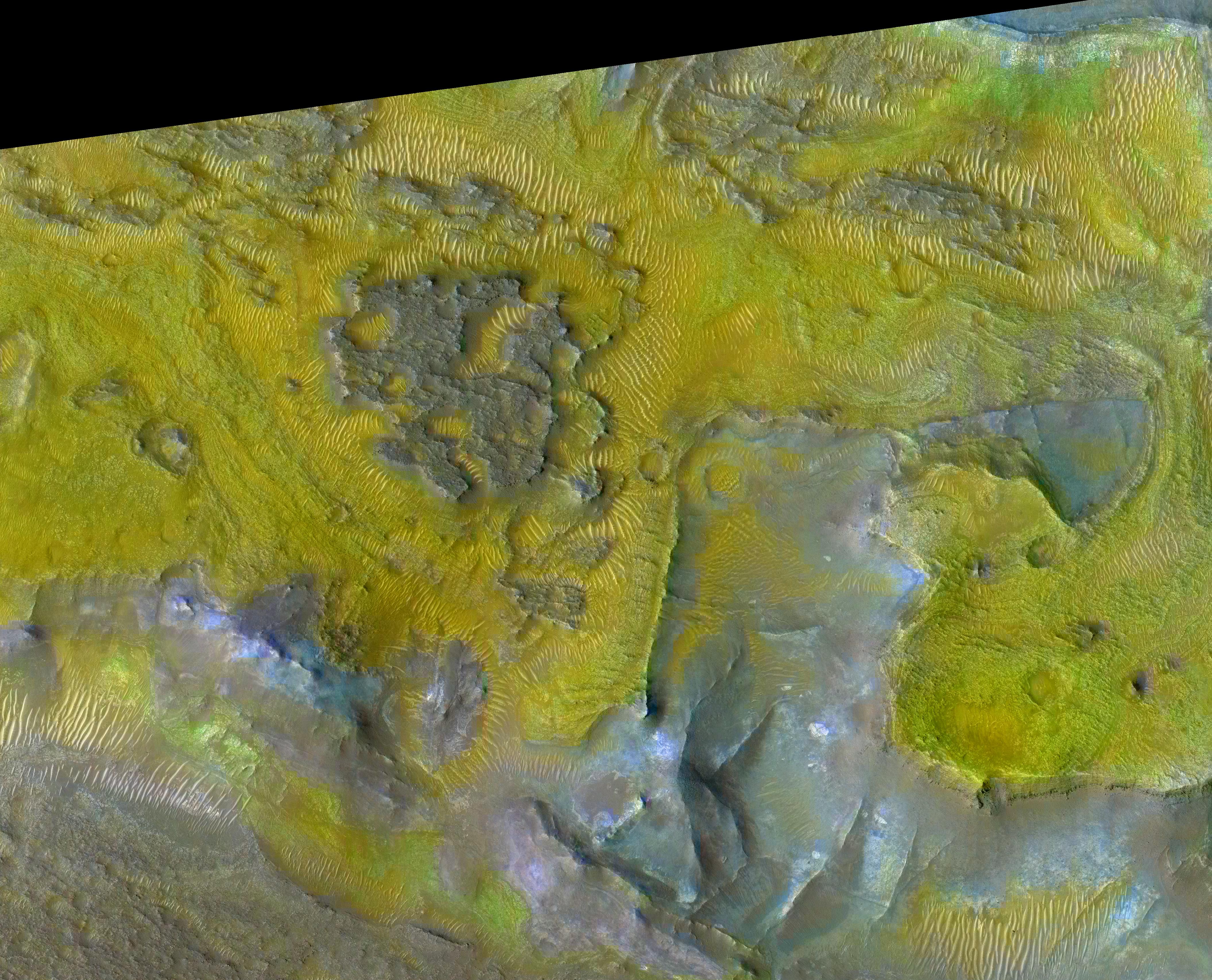
Alteration of the Crust Beneath a Highland Crater
Full Resolution:
TIFF
(5.275 MB)
JPEG
(188.7 kB)
|
|
|
2008-01-04 |
Mars
|
Mars Reconnaissance Orbiter (MRO)
|
CRISM
|
1126x1800x3 |
|
-
PIA10223:
-
Eolian Features Provide a Glimpse of Candor Chasma Mineralology
Full Resolution:
TIFF
(6.088 MB)
JPEG
(267.1 kB)
|
|
|
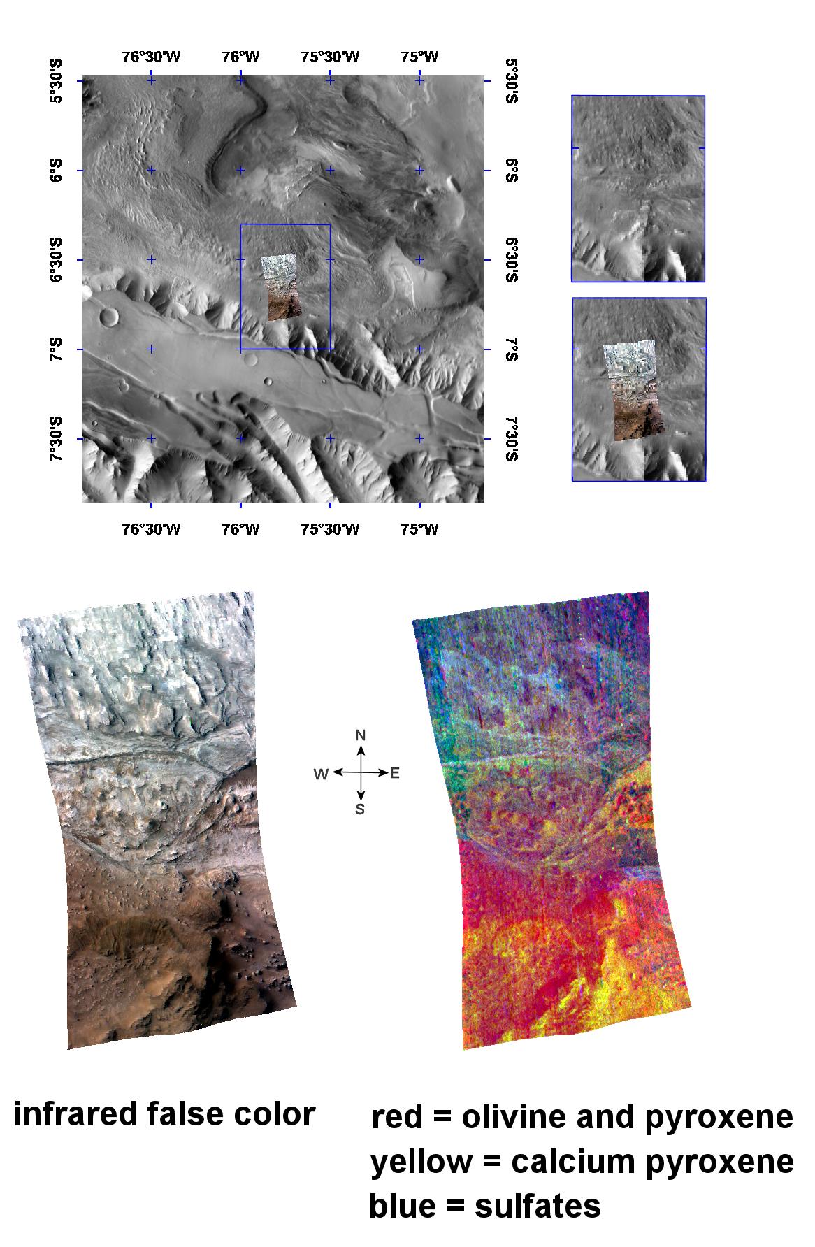
2008-02-05 |
Mars
|
Mars Reconnaissance Orbiter (MRO)
|
CRISM
|
870x1150x3 |
|
-
PIA10180:
-
Interior Layered Deposits in Tithonium Chasma Reveal Diverse Compositions
Full Resolution:
TIFF
(3.005 MB)
JPEG
(146 kB)
|
|
|
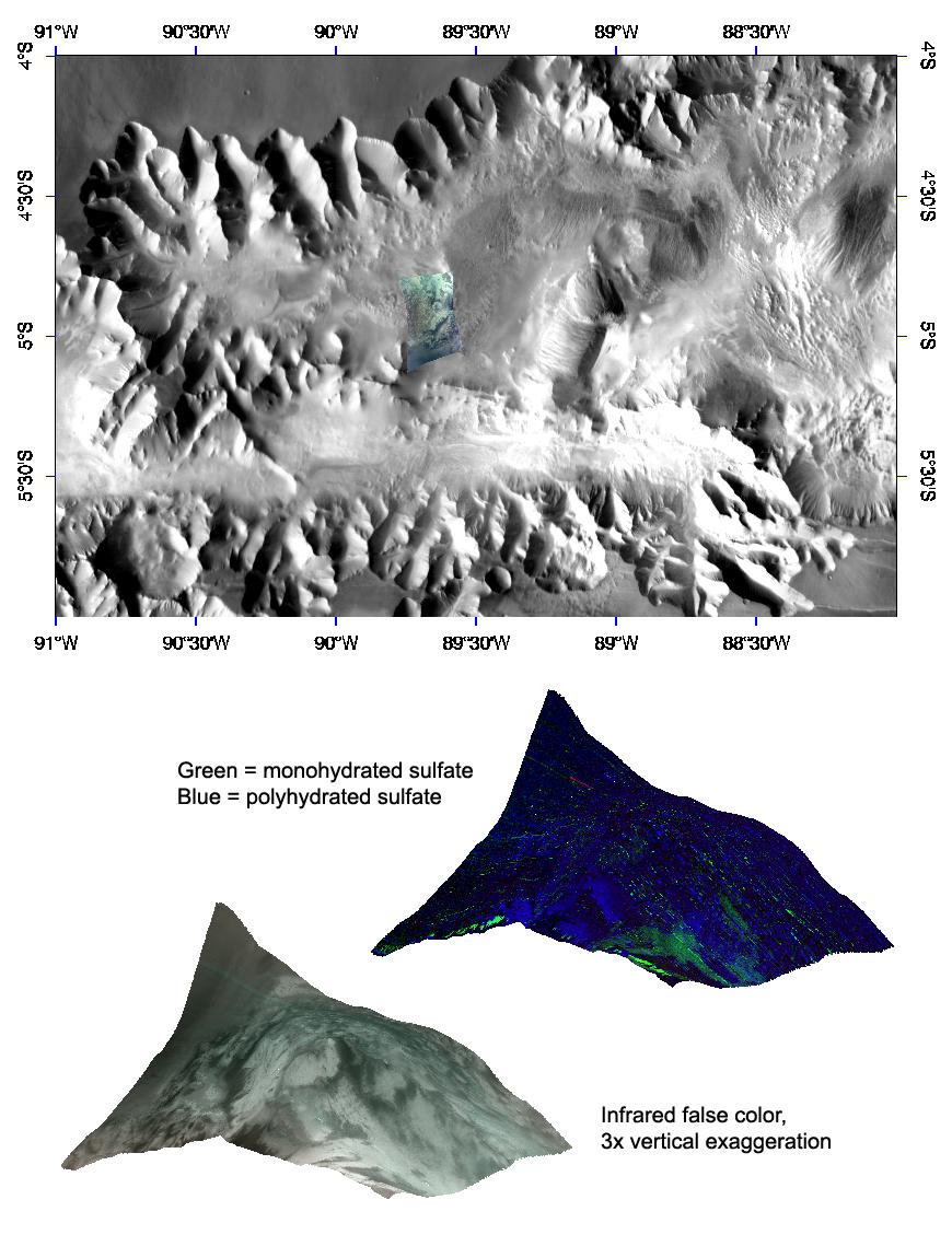
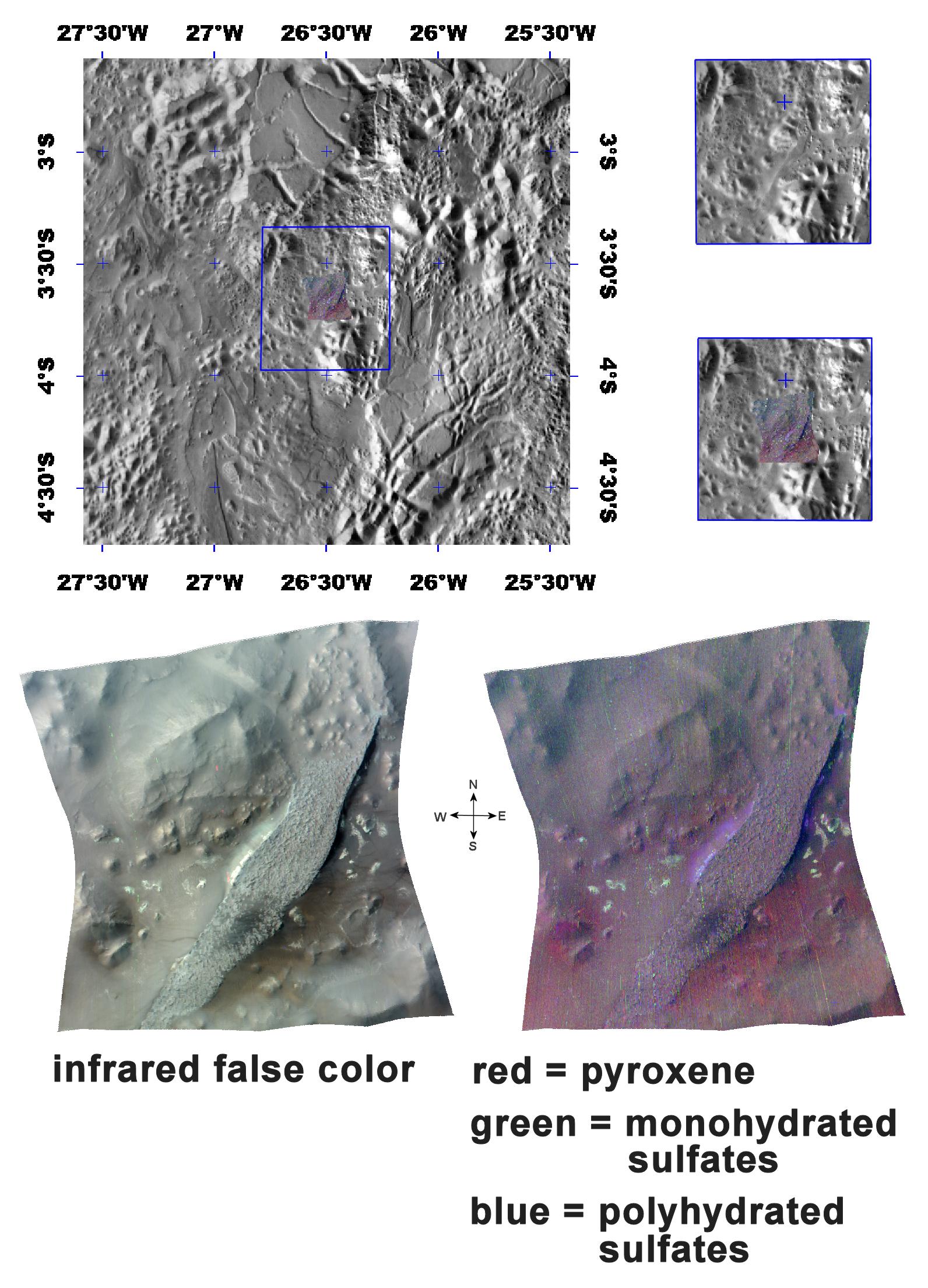
2008-02-14 |
Mars
|
Mars Reconnaissance Orbiter (MRO)
|
CRISM
|
797x1863x3 |
|
-
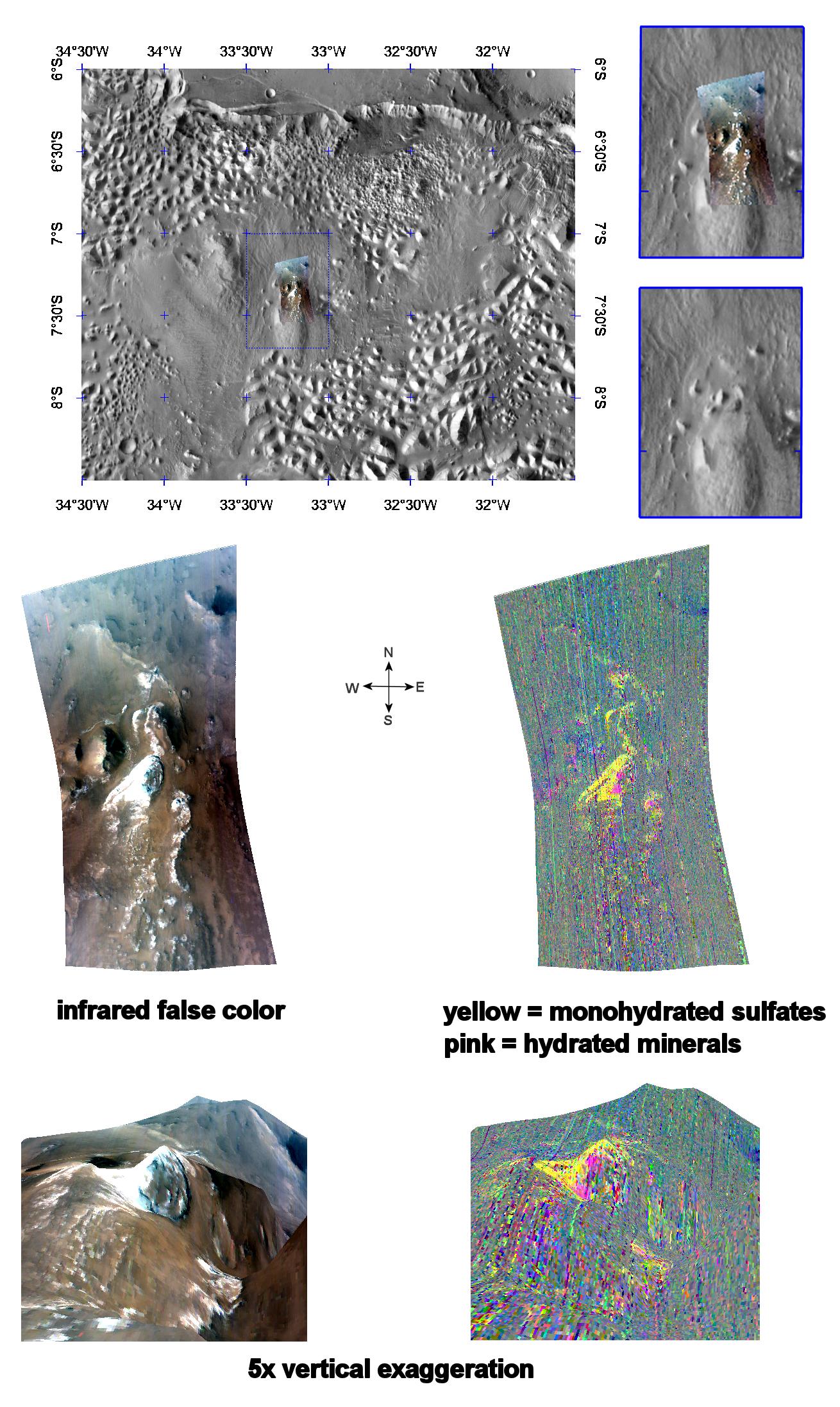
PIA10636:
-
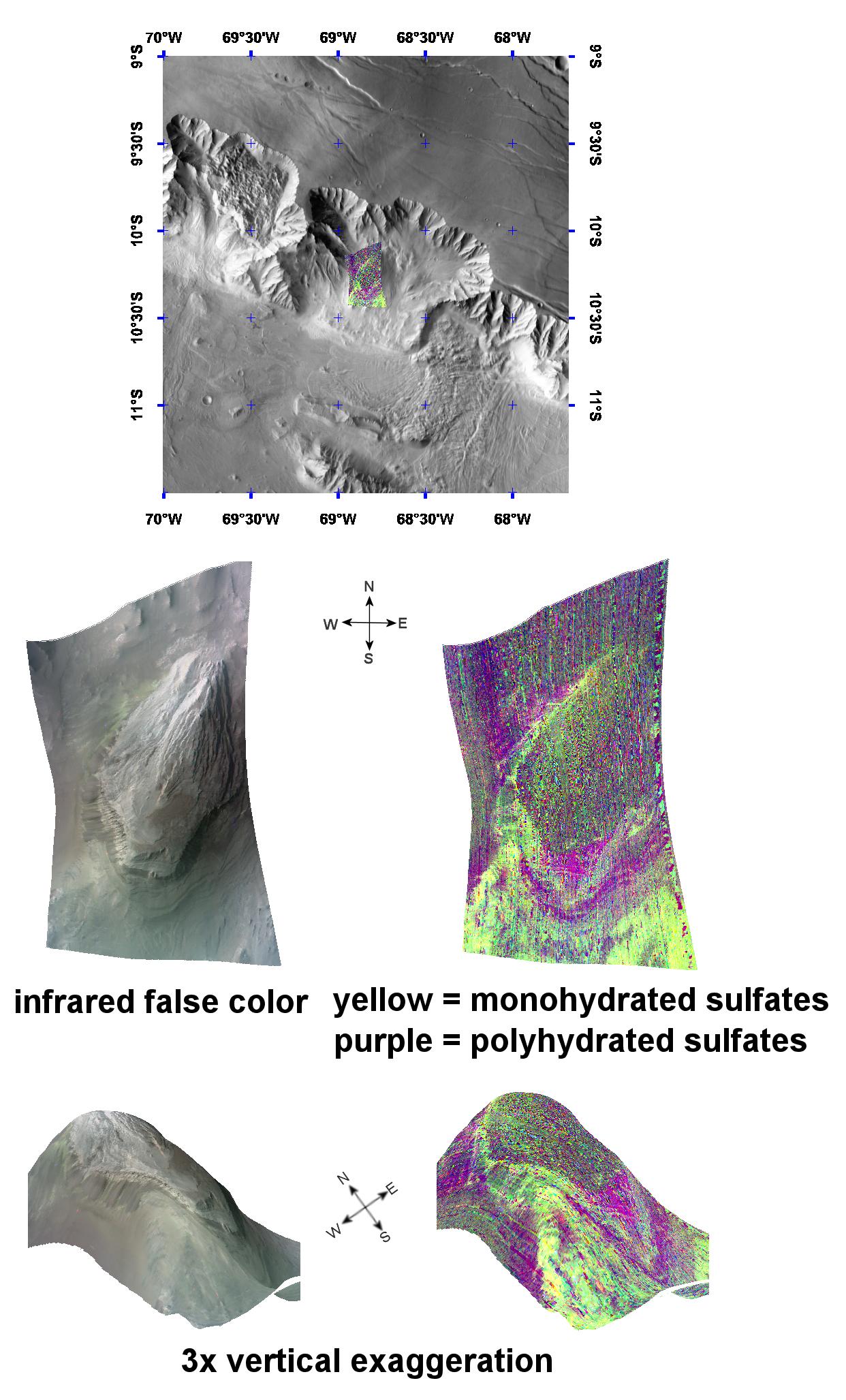
Mono- & Polyhydrated Sulfates in Aureum Chaos
Full Resolution:
TIFF
(4.46 MB)
JPEG
(251.4 kB)
|
|
|
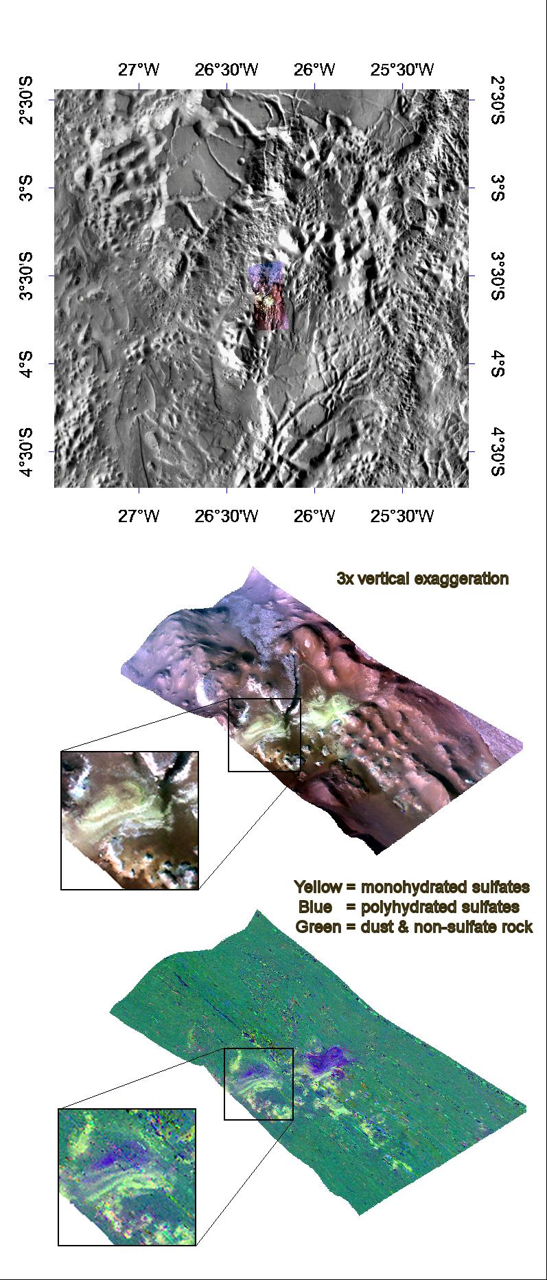
2008-03-01 |
Mars
|
Mars Reconnaissance Orbiter (MRO)
|
CRISM
|
797x1548x3 |
|
-
PIA10637:
-
Pollack Crater's White Rock
Full Resolution:
TIFF
(3.706 MB)
JPEG
(188.6 kB)
|
|
|
2008-03-06 |
Mars
|
Mars Reconnaissance Orbiter (MRO)
|
CRISM
|
988x2046x3 |

|
-
PIA10638:
-
Mono- and Polyhydrated Sulfates in Tithonium Chasma
Full Resolution:
TIFF
(6.073 MB)
JPEG
(312.3 kB)
|
|
|
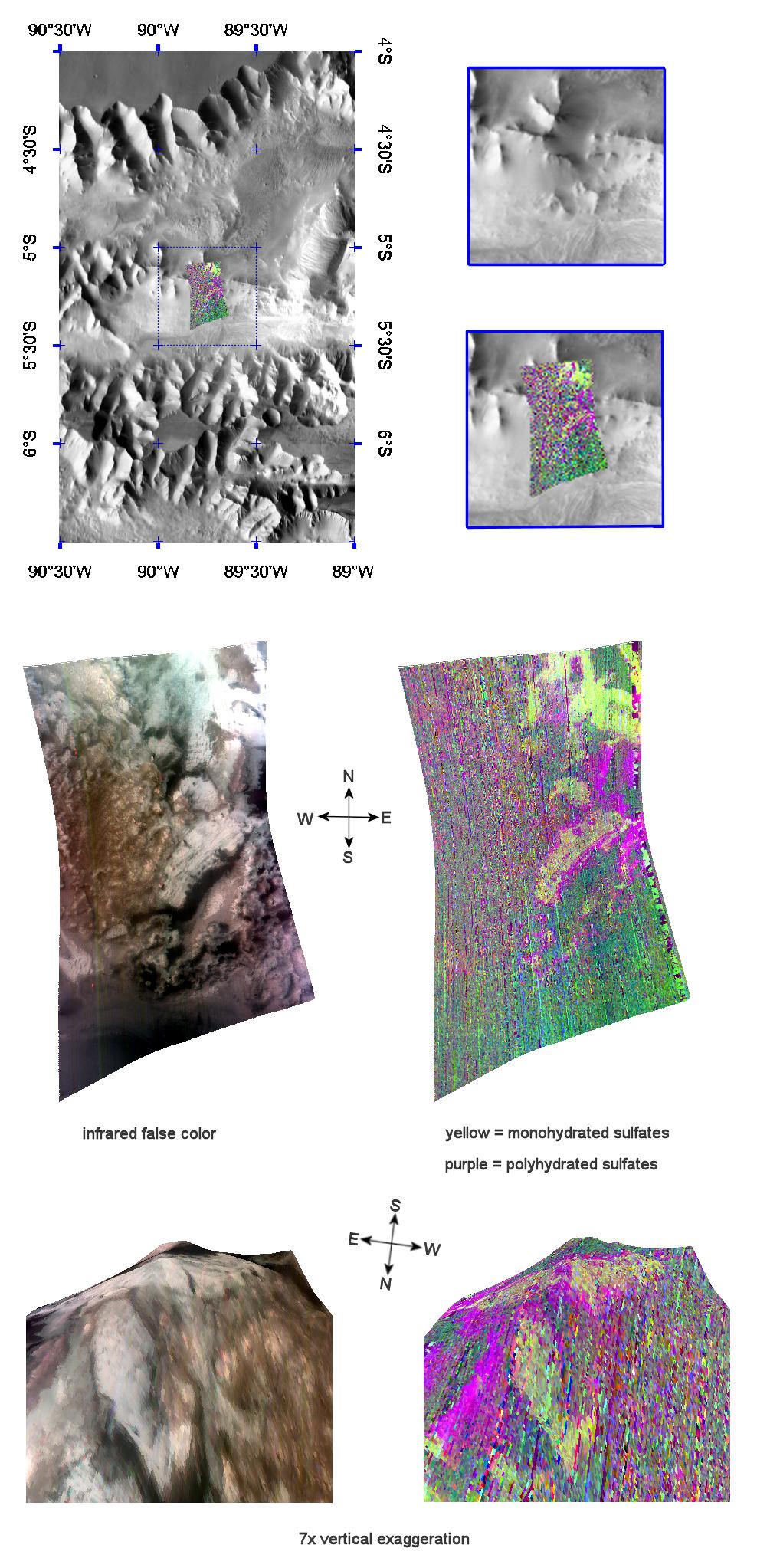
2008-03-18 |
Mars
|
Mars Reconnaissance Orbiter (MRO)
|
CRISM
|
1310x2193x3 |
|
-
PIA10639:
-
Monohydrated Sulfates in Aurorae Chaos
Full Resolution:
TIFF
(8.628 MB)
JPEG
(444.9 kB)
|
|
|
2008-03-25 |
Mars
|
Mars Reconnaissance Orbiter (MRO)
|
CRISM
|
1130x1490x3 |
|
-
PIA10640:
-
Durham, North Carolina, Students Study Martian Volcanism
Full Resolution:
TIFF
(5.057 MB)
JPEG
(253.4 kB)
|
|
|
2008-03-28 |
Mars
|
Mars Reconnaissance Orbiter (MRO)
|
CRISM
|
1130x1490x3 |
|
-
PIA10641:
-
Livonia, New York, Students Study Past Martian Water
Full Resolution:
TIFF
(5.057 MB)
JPEG
(227.9 kB)
|
|
|
2008-04-03 |
Mars
|
Mars Reconnaissance Orbiter (MRO)
|
CRISM
|
1242x2055x3 |
|
-
PIA10643:
-
Complex Sulfate Deposits in Coprates Chasma
Full Resolution:
TIFF
(7.665 MB)
JPEG
(320.6 kB)
|
|
|
2008-04-01 |
Mars
|
Mars Reconnaissance Orbiter (MRO)
|
CRISM
|
1646x1774x3 |
|
-
PIA10642:
-
Olivine & Phyllosilicates in Nili Fossae
Full Resolution:
TIFF
(8.774 MB)
JPEG
(463.9 kB)
|
|
|
2008-04-29 |
Mars
|
Mars Reconnaissance Orbiter (MRO)
|
CRISM
|
1166x1784x3 |
|
-
PIA10644:
-
The Minerals of Candor Chasma
Full Resolution:
TIFF
(6.248 MB)
JPEG
(266.8 kB)
|
|
|
2008-05-09 |
Mars
|
Mars Reconnaissance Orbiter (MRO)
|
CRISM
|
1592x2208x3 |
|
-
PIA10943:
-
The Minerals of Aureum Chaos
Full Resolution:
TIFF
(10.56 MB)
JPEG
(449.5 kB)
|
|
|
2008-05-15 |
Mars
|
Mars Reconnaissance Orbiter (MRO)
|
CRISM
|
1684x1552x3 |
|
-
PIA10944:
-
Mawrth Vallis Phyllosilicates
Full Resolution:
TIFF
(7.853 MB)
JPEG
(381.5 kB)
|
|
|
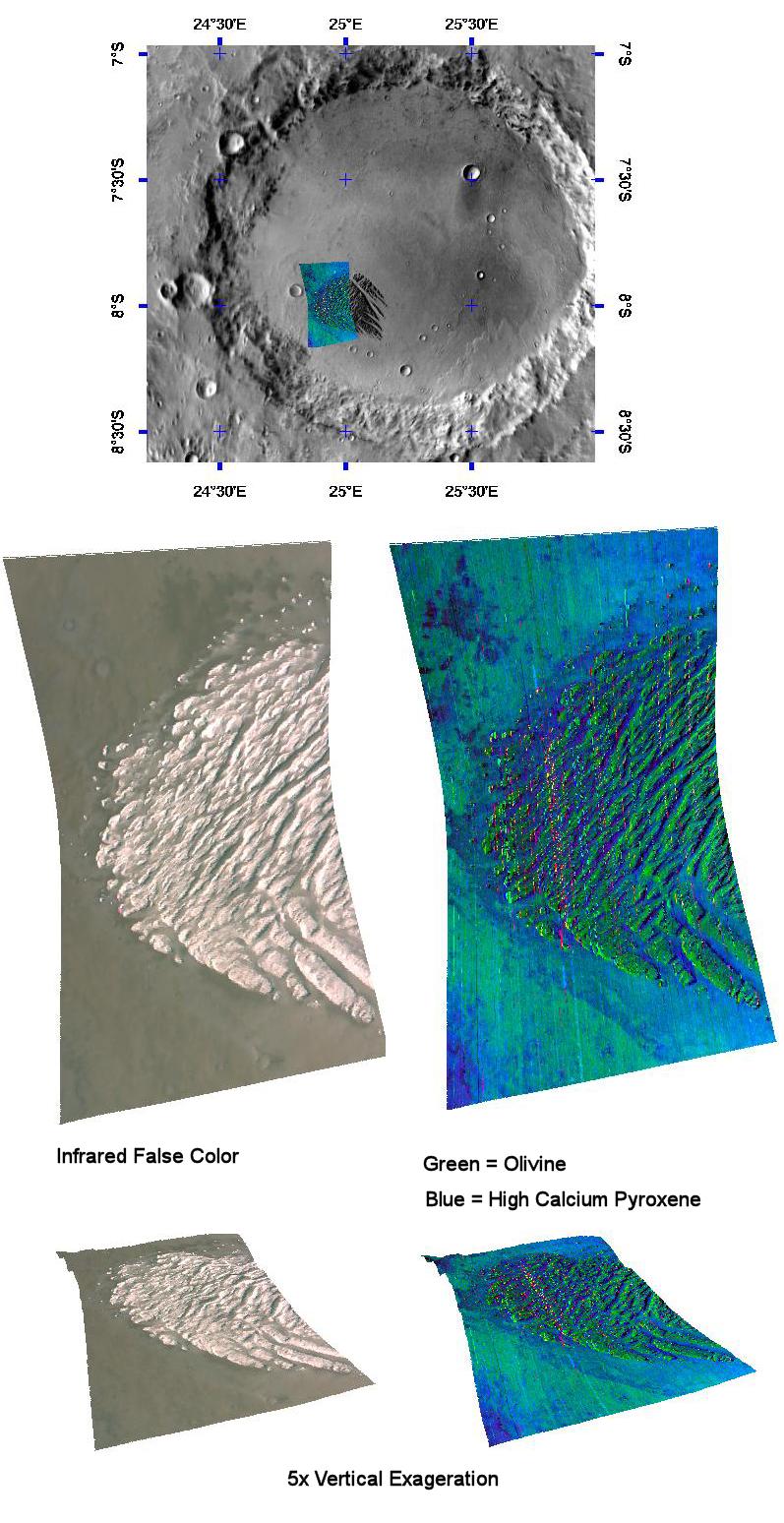
2008-05-20 |
Mars
|
Mars Reconnaissance Orbiter (MRO)
|
CRISM
|
1576x1688x3 |
|
-
PIA10945:
-
An Olivine-Rich Crater in Tyrrhena Terra
Full Resolution:
TIFF
(7.995 MB)
JPEG
(282.7 kB)
|
|
|
2008-05-30 |
Mars
|
Mars Reconnaissance Orbiter (MRO)
|
CRISM
|
1109x1500x3 |
|
-
PIA10946:
-
Gypsum Dunes North of Phoenix Landing Site
Full Resolution:
TIFF
(4.997 MB)
JPEG
(202.4 kB)
|
|
|
2008-06-24 |
Mars
|
Mars Reconnaissance Orbiter (MRO)
|
CRISM
|
1312x1795x3 |
|
-
PIA10947:
-
Oudemans Crater
Full Resolution:
TIFF
(7.073 MB)
JPEG
(217.1 kB)
|
|
|
2008-06-27 |
Mars
|
Mars Reconnaissance Orbiter (MRO)
|
CRISM
|
1264x1052x3 |
|
-
PIA10948:
-
Water Past and Present
Full Resolution:
TIFF
(3.994 MB)
JPEG
(134.9 kB)
|
|
|
2008-06-30 |
Mars
|
Mars Reconnaissance Orbiter (MRO)
|
CRISM
|
1693x1875x3 |
|
-
PIA10949:
-
Olivine, Phyllosilicates, and Ancient Crater Rims
Full Resolution:
TIFF
(9.538 MB)
JPEG
(397.9 kB)
|
|
|
2008-08-08 |
Mars
|
Mars Reconnaissance Orbiter (MRO)
|
CRISM
|
832x412x3 |
|
-
PIA11011:
-
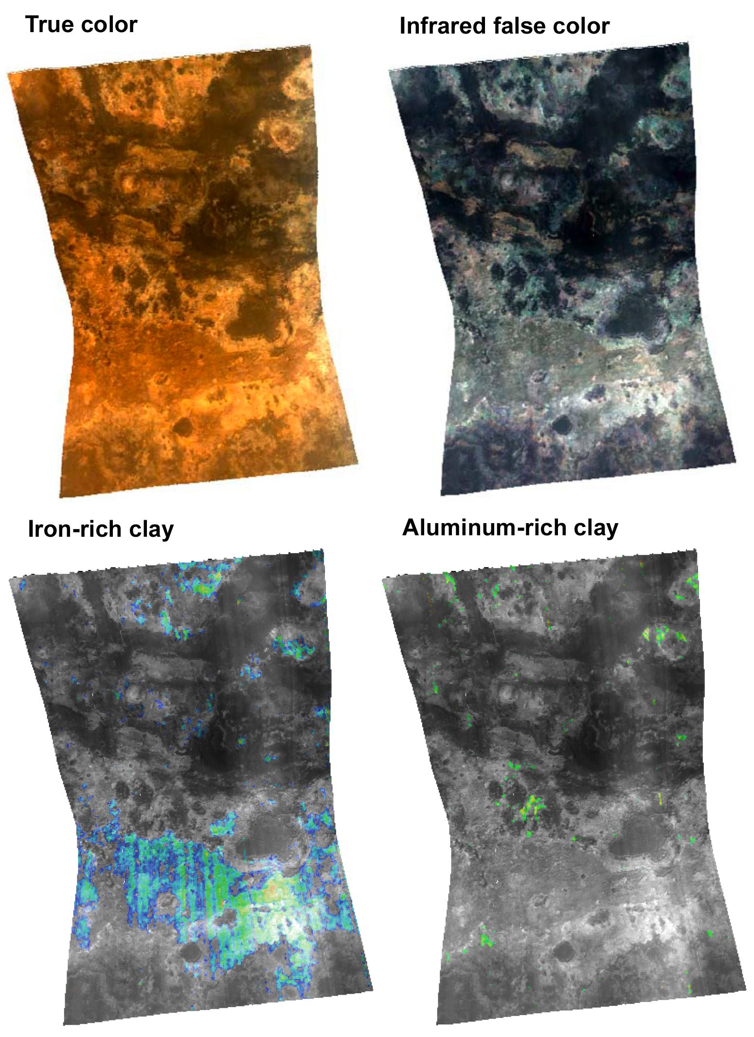
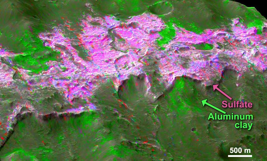
Clay Minerals in Mawrth Vallis Region of Mars
Full Resolution:
TIFF
(1.03 MB)
JPEG
(82.26 kB)
|
|
|
2008-09-19 |
Mars
|
Mars Reconnaissance Orbiter (MRO)
|
CRISM
|
720x720x3 |
|
-
PIA11175:
-
Growing Library of Mars Spectrometer Images
Full Resolution:
TIFF
(1.557 MB)
JPEG
(67.77 kB)
|
|
|
2008-12-18 |
Mars
|
Mars Reconnaissance Orbiter (MRO)
|
CRISM
|
677x640x3 |
|
-
PIA11728:
-
Mineral Spectra from Nili Fossae, Mars
Full Resolution:
TIFF
(435.5 kB)
JPEG
(43.35 kB)
|
|
|
2008-12-18 |
Mars
|
Mars Reconnaissance Orbiter (MRO)
|
CRISM
|
2159x1055x3 |
|
-
PIA11729:
-
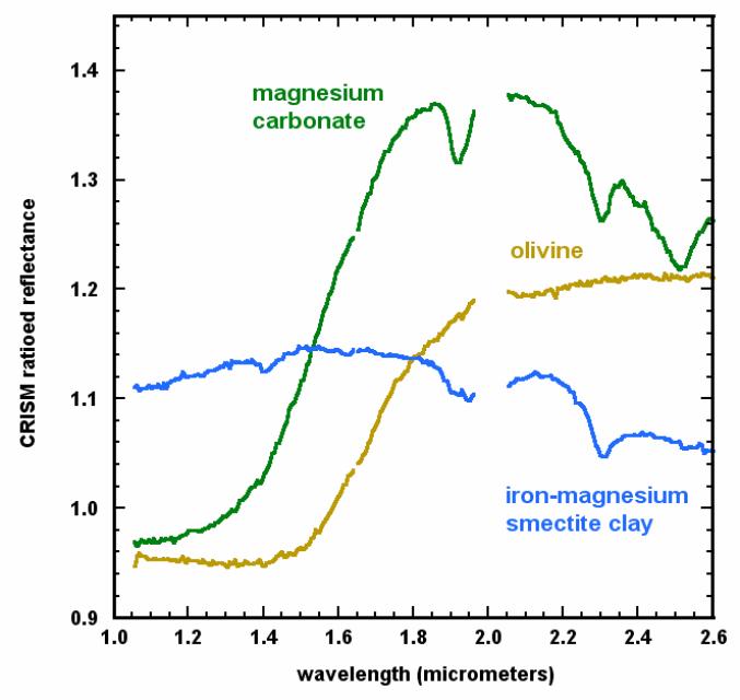
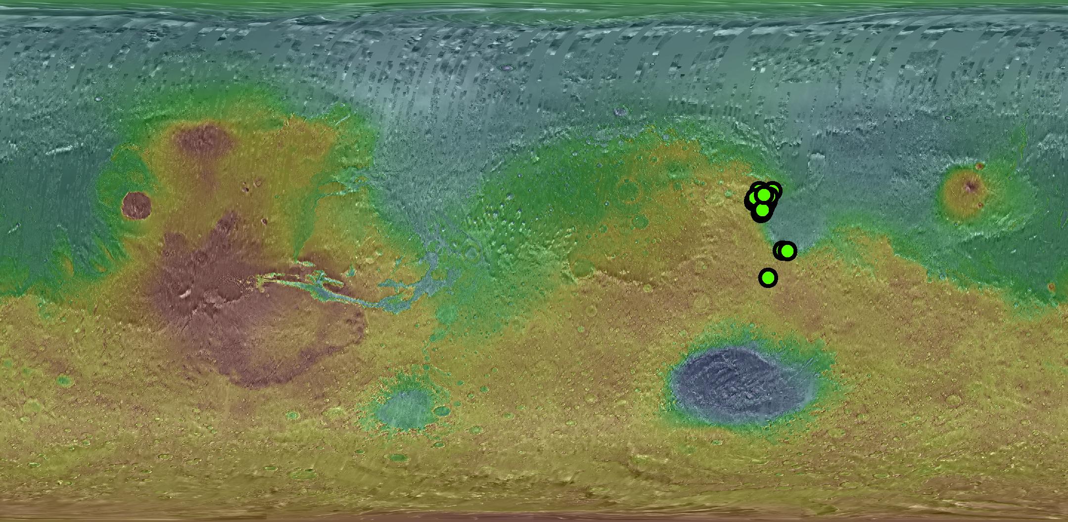
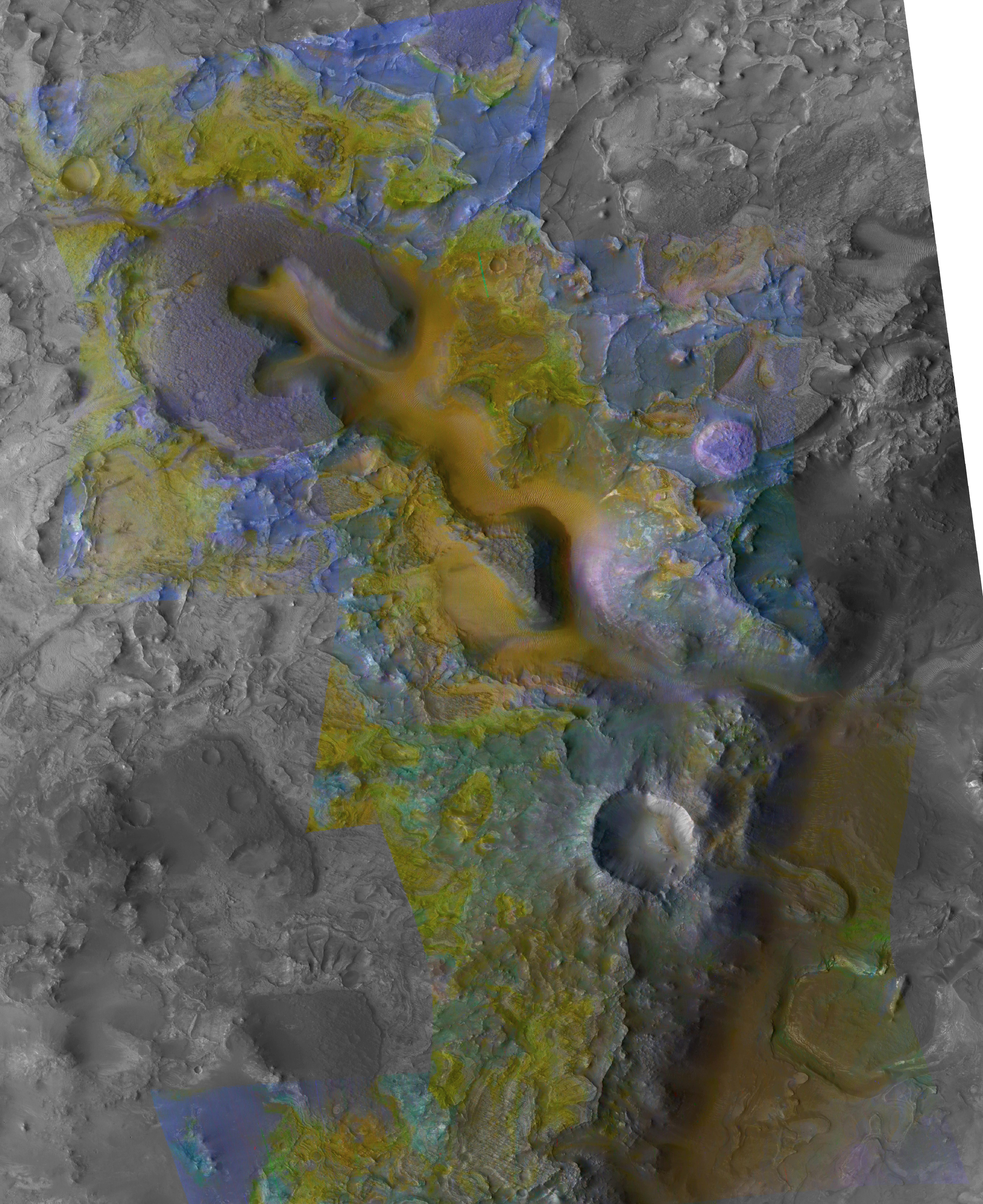
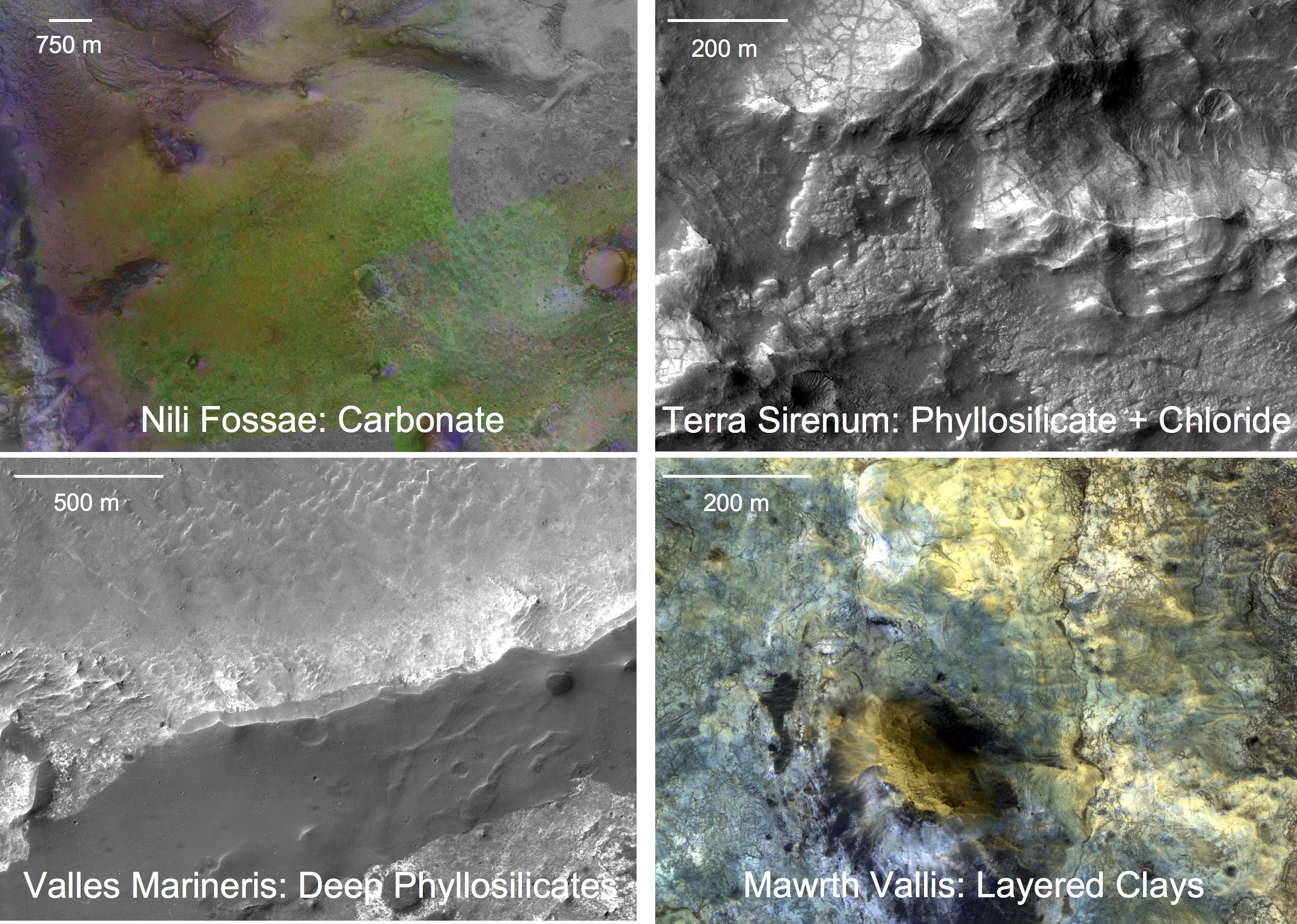
Known Locations of Carbonate Rocks on Mars
Full Resolution:
TIFF
(6.842 MB)
JPEG
(459.5 kB)
|
|
|
2008-12-18 |
Mars
|
Mars Reconnaissance Orbiter (MRO)
|
CRISM
|
4222x3413x3 |
|
-
PIA11730:
-
Carbonate-Olivine Relationship in Nile Fossae, Mars
Full Resolution:
TIFF
(43.23 MB)
JPEG
(2.86 MB)
|
|
|
2008-12-18 |
Mars
|
Mars Reconnaissance Orbiter (MRO)
|
CRISM
|
5086x6227x3 |
|
-
PIA11731:
-
Context of Carbonate Rocks in Heavily Eroded Martian Terrain
Full Resolution:
TIFF
(95.01 MB)
JPEG
(3.072 MB)
|
|
|
2008-12-18 |
Mars
|
Mars Reconnaissance Orbiter (MRO)
|
CRISM
|
2718x1936x3 |
|
-
PIA11732:
-
Four Types of Deposits From Wet Conditions on Early Mars
Full Resolution:
TIFF
(15.8 MB)
JPEG
(886.6 kB)
|
|
|
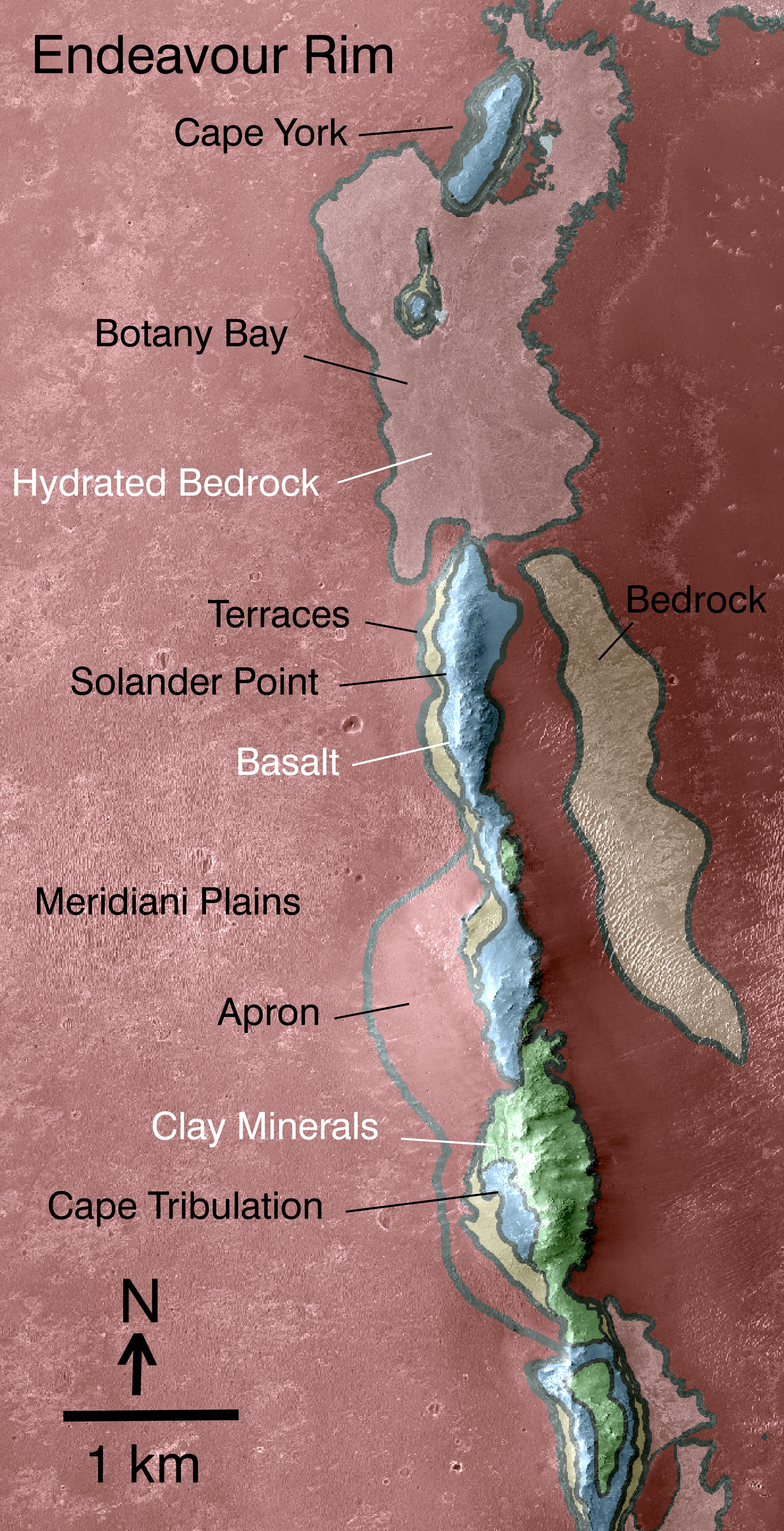
2010-12-16 |
Mars
|
Mars Reconnaissance Orbiter (MRO)
|
CRISM
|
2736x2250x3 |
|
-
PIA13704:
-
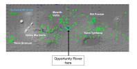
Geologic Setting of Opportunity Traverse and Meridiani Planum
Full Resolution:
TIFF
(18.47 MB)
JPEG
(486.1 kB)
|
|
|
2010-12-16 |
Mars
|
Mars Reconnaissance Orbiter (MRO)
|
CRISM
|
4023x7854x3 |

|
-
PIA13708:
-
Geologic Map, West Rim of Endeavour Crater, Mars
Full Resolution:
TIFF
(94.79 MB)
JPEG
(4.431 MB)
|
|
|
2011-11-02 |
Mars
|
Mars Reconnaissance Orbiter (MRO)
|
CRISM
|
2000x2000x3 |
|
-
PIA14764:
-
Clay Minerals in Craters and Escarpments on Mars
Full Resolution:
TIFF
(12.02 MB)
JPEG
(262.6 kB)
|
|
|
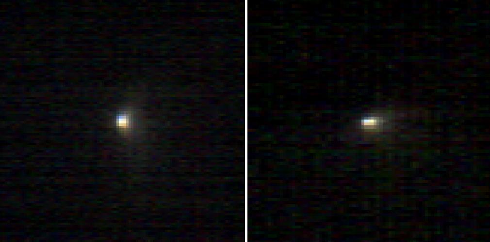
2014-10-24 |
Mars
|
Mars Reconnaissance Orbiter (MRO)
|
CRISM
|
1010x500x3 |
|
-
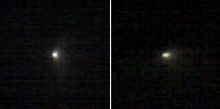
PIA15291:
-
Images From Mars-Orbiting Spectrometer Show Comet's Coma
Full Resolution:
TIFF
(1.516 MB)
JPEG
(38.03 kB)
|
|
|
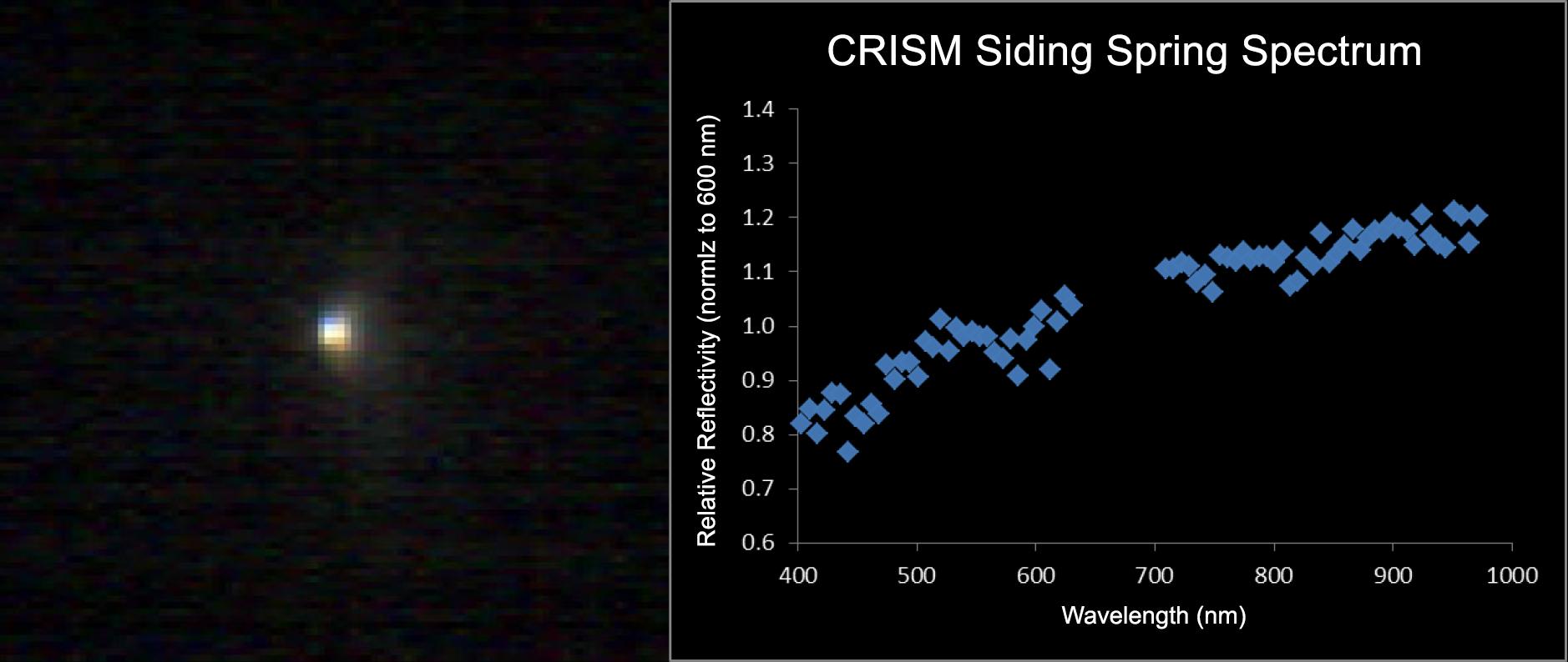
2014-11-07 |
Mars
|
Mars Reconnaissance Orbiter (MRO)
|
CRISM
|
1878x794x3 |
|
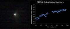
-
PIA18865:
-
Mars-Orbiting Spectrometer Shows Dusty Comet's Spectrum
Full Resolution:
TIFF
(4.475 MB)
JPEG
(94.77 kB)
|
|
|
2015-06-08 |
Mars
|
Mars Reconnaissance Orbiter (MRO)
|
CRISM
|
1551x938x3 |
|
-
PIA19673:
-
Spectral Signals Indicating Impact Glass on Mars
Full Resolution:
TIFF
(4.366 MB)
JPEG
(201.2 kB)
|
|
|
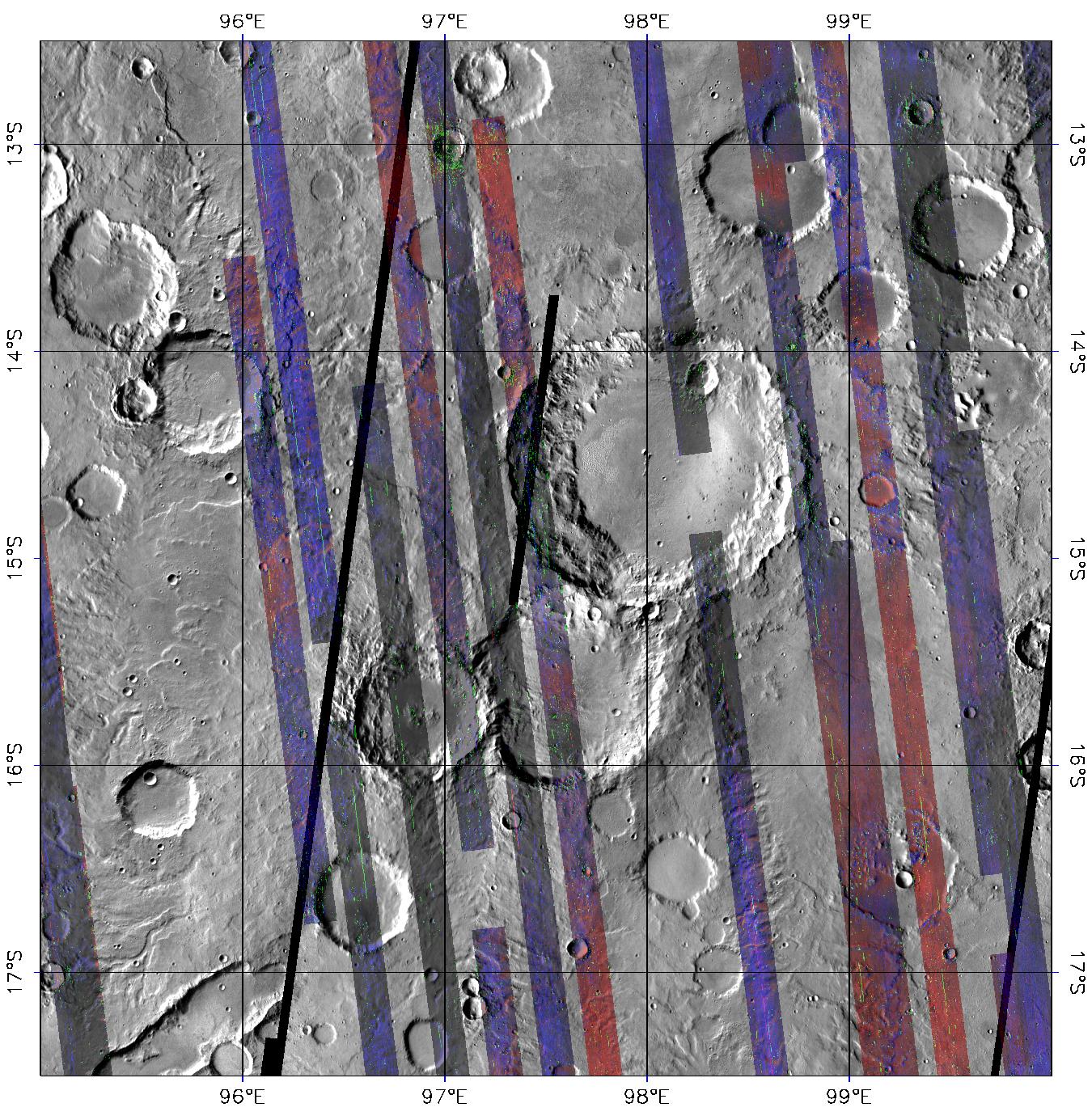
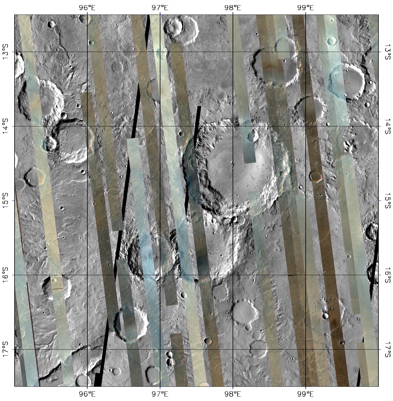
2022-06-23 |
Mars
|
Mars Reconnaissance Orbiter (MRO)
|
CRISM
|
5204x2919x3 |
|
-
PIA25363:
-
One of CRISM's Final Maps of Mars
Full Resolution:
TIFF
(27.48 MB)
JPEG
(3.126 MB)
|
|
|
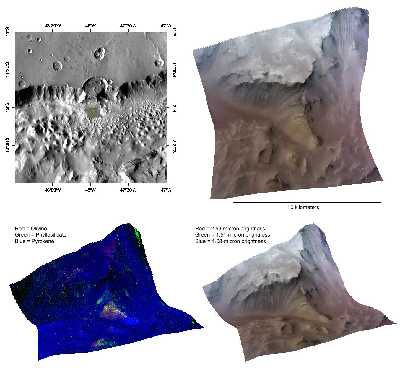
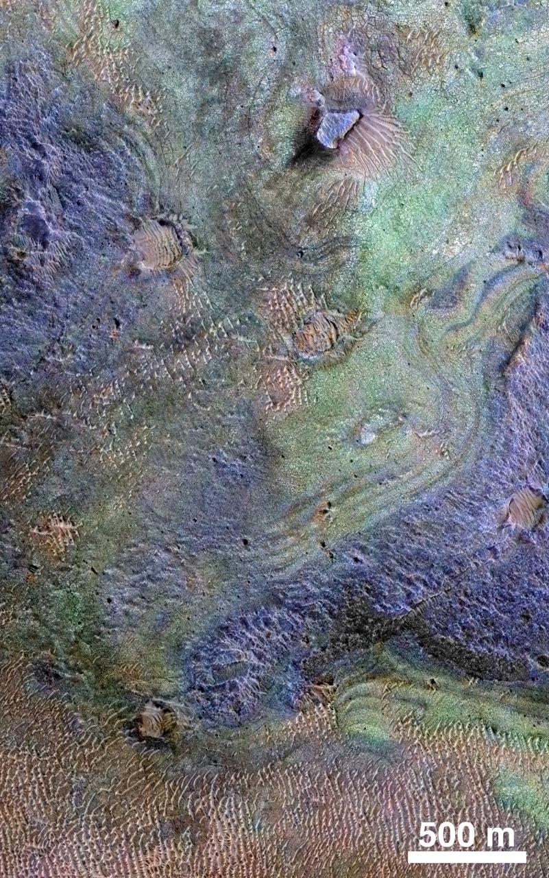
2022-06-23 |
Mars
|
Mars Reconnaissance Orbiter (MRO)
|
CRISM
|
1600x900x3 |
|
-
PIA25364:
-
Six Views of Nili Fossae, as Seen by MRO's CRISM
Full Resolution:
TIFF
(4.022 MB)
JPEG
(329.6 kB)
|
|
|
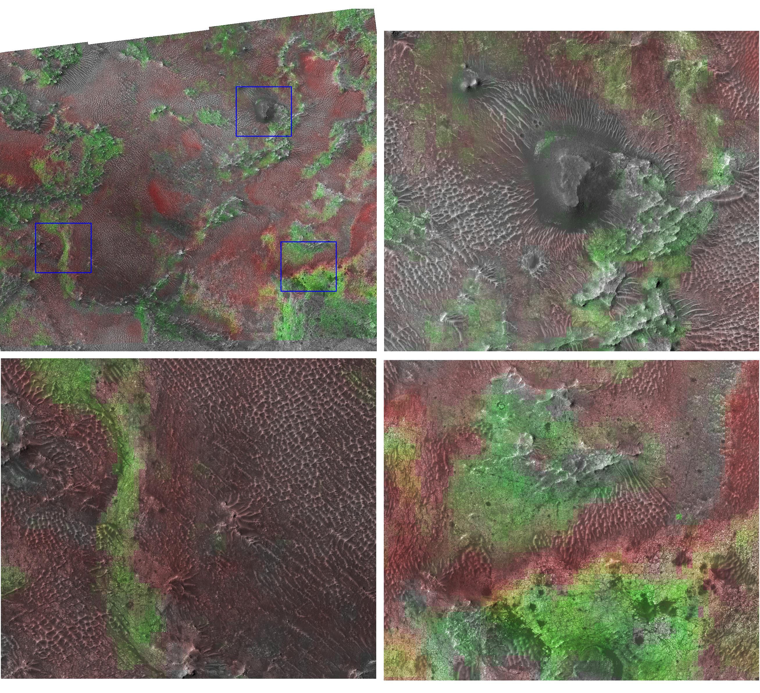
2006-12-13 |
Mars
|
Mars Reconnaissance Orbiter (MRO)
|
CRISM
High Resolution Imaging Science Experiment (HiRISE)
|
2614x2383x3 |
|
-
PIA09093:
-
Clay at Nili Fossae
Full Resolution:
TIFF
(18.71 MB)
JPEG
(1.42 MB)
|
|
|
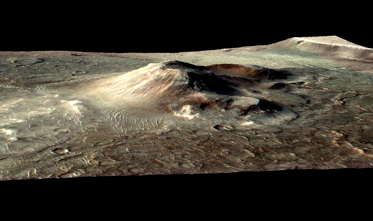
2010-10-31 |
Mars
|
Mars Reconnaissance Orbiter (MRO)
|
CRISM
CTX
|
1472x874x3 |
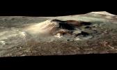
|
-
PIA13556:
-
Mars Volcanic Cone with Hydrothermal Deposits
Full Resolution:
TIFF
(3.867 MB)
JPEG
(193.8 kB)
|
|
|
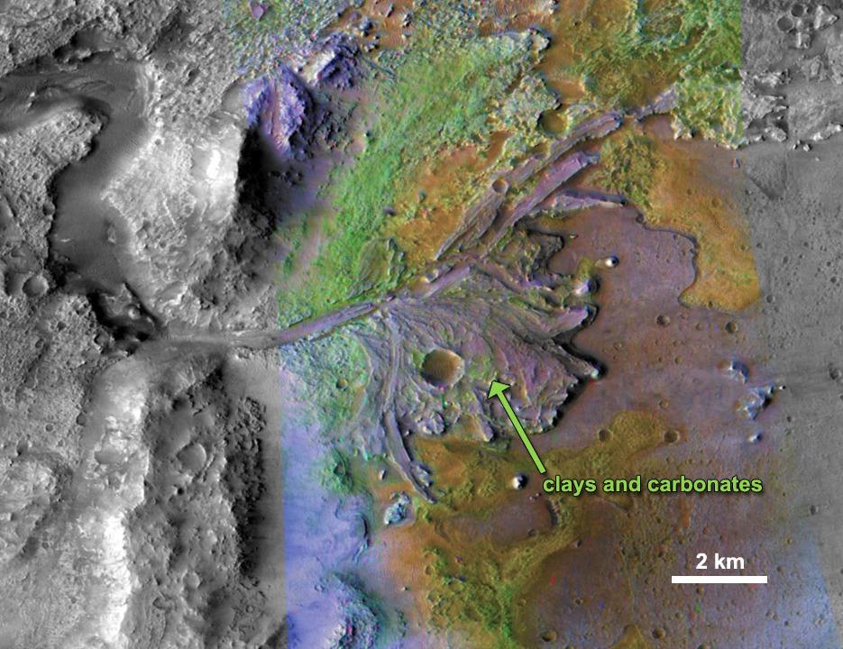
2011-11-21 |
Mars
|
Mars Reconnaissance Orbiter (MRO)
|
CRISM
CTX
|
935x720x3 |
|
-
PIA15097:
-
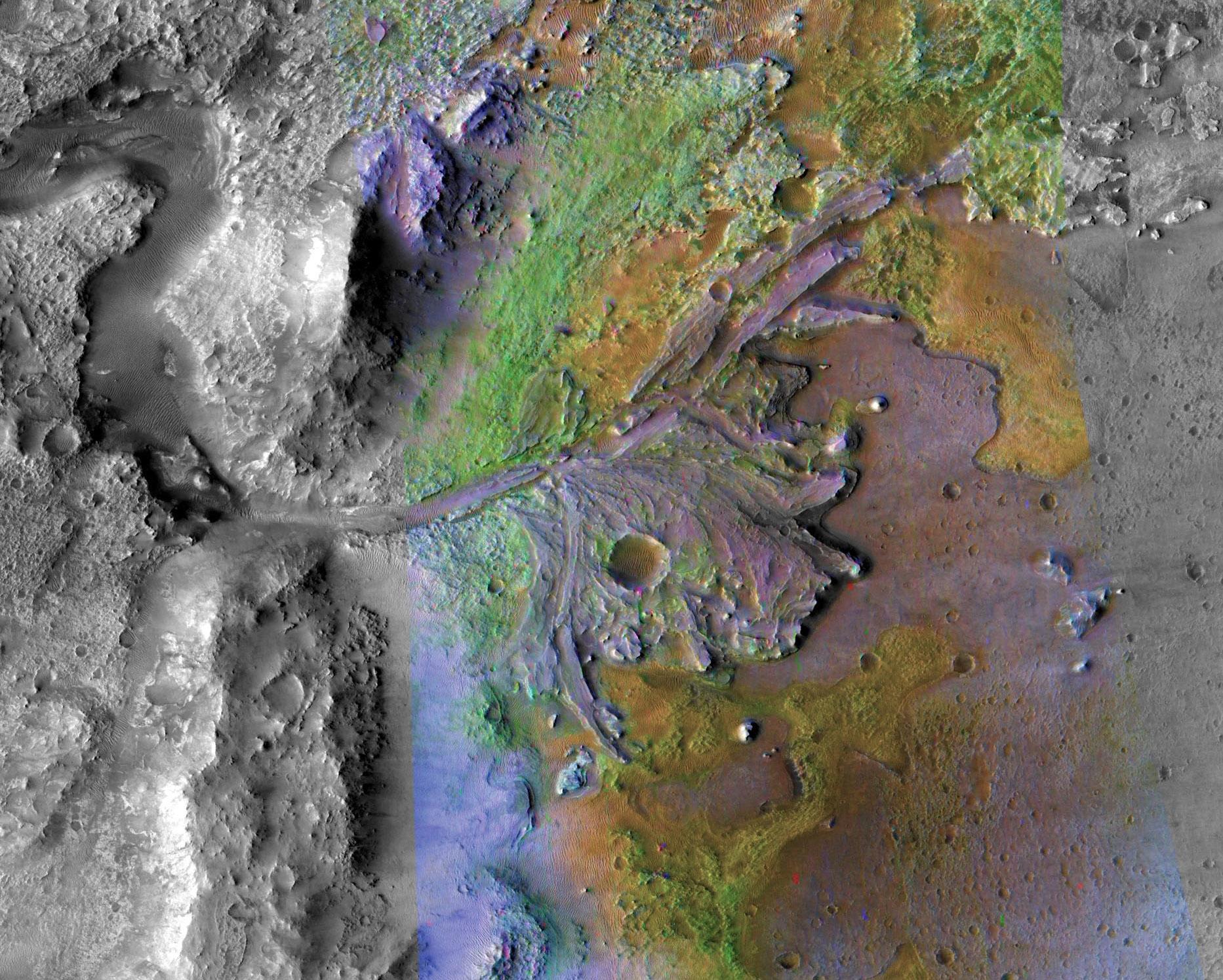
Chemical Alteration by Water, Jezero Crater Delta
Full Resolution:
TIFF
(2.023 MB)
JPEG
(132 kB)
|
|
|
2011-11-21 |
Mars
|
Mars Reconnaissance Orbiter (MRO)
|
CRISM
CTX
|
857x517x3 |

|
-
PIA15099:
-
Sulfates and Clays in Columbus Crater, Mars
Full Resolution:
TIFF
(1.331 MB)
JPEG
(97.63 kB)
|
|
|
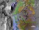
2019-05-15 |
Mars
|
Mars Reconnaissance Orbiter (MRO)
|
CRISM
CTX
|
1865x1495x3 |
|
-
PIA23239:
-
Jezero Crater, Mars 2020's Landing Site
Full Resolution:
TIFF
(8.341 MB)
JPEG
(550.2 kB)
|
|
|
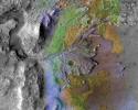
2019-11-12 |
Mars
|
Mars Reconnaissance Orbiter (MRO)
|
CRISM
CTX
|
3639x2535x3 |

|
-
PIA23380:
-
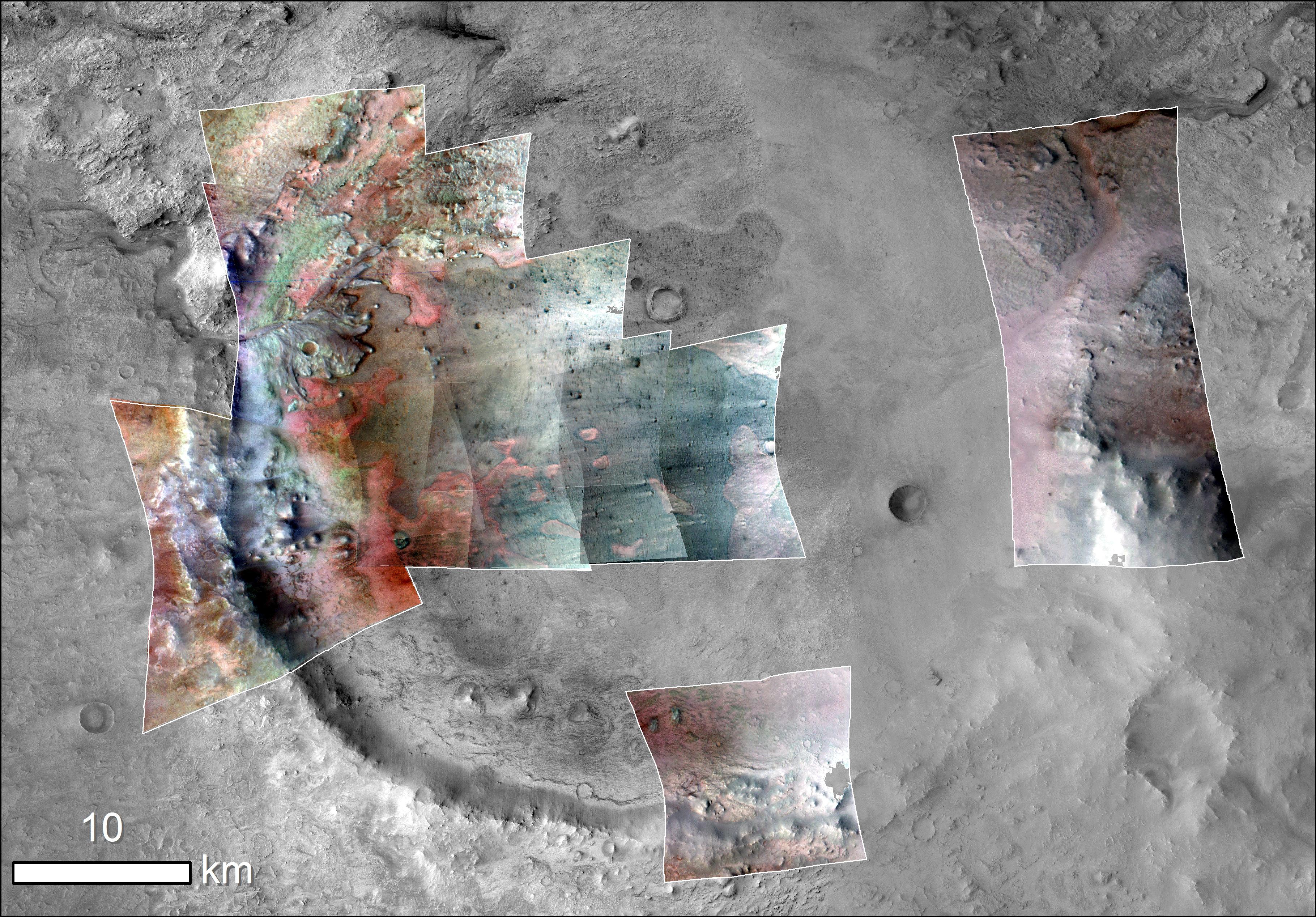
Jezero Crater Minerals
Full Resolution:
TIFF
(12.61 MB)
JPEG
(2.144 MB)
|
|
|
2019-11-12 |
Mars
|
Mars Reconnaissance Orbiter (MRO)
Mars Express (MEX)
Mars Global Surveyor (MGS)
|
CRISM
CTX
MOLA
High Resolution Stereo Camera
|
3663x2535x3 |
|
-
PIA23511:
-
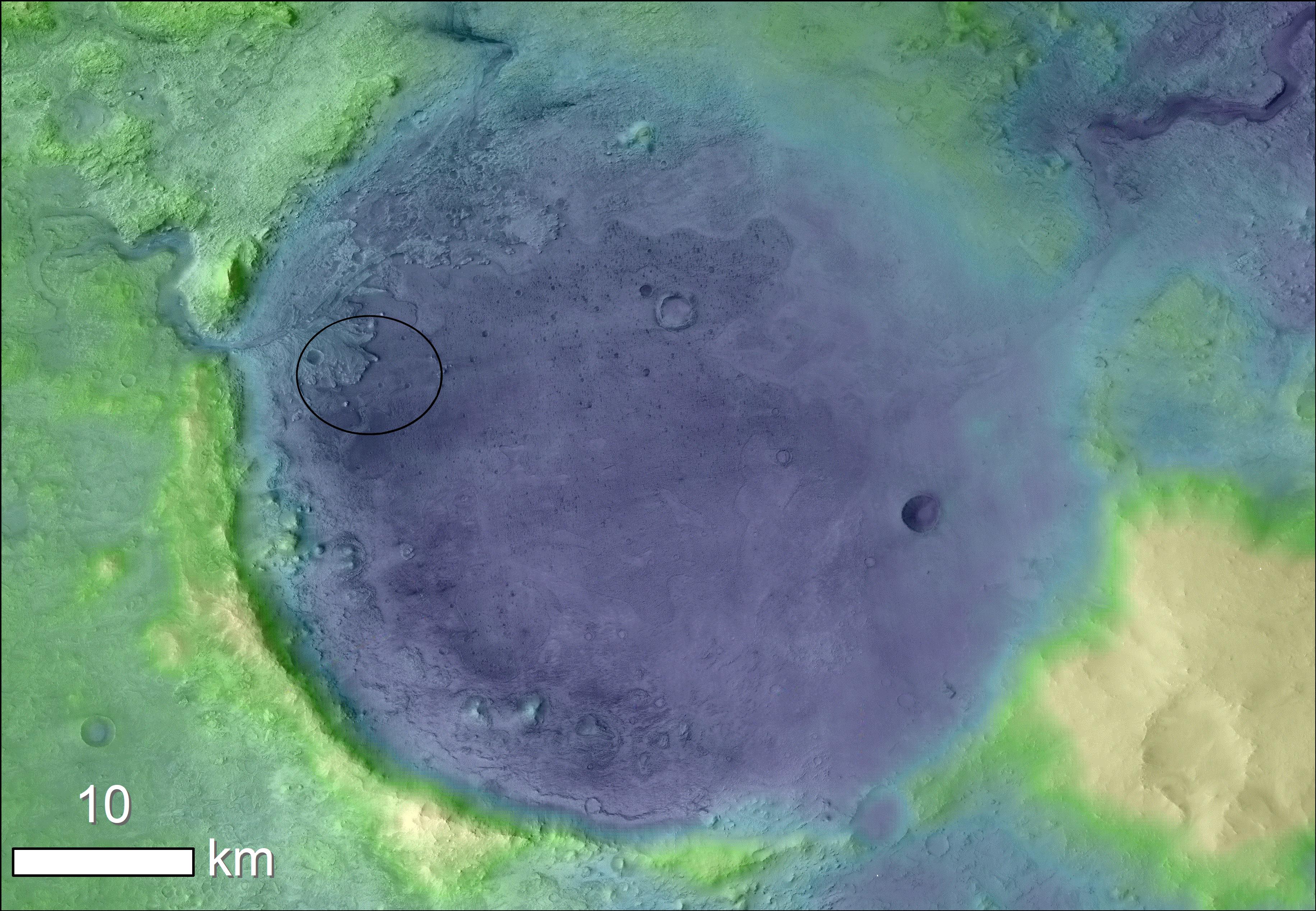
Jezero Crater's Ancient Lakeshore
Full Resolution:
TIFF
(16.31 MB)
JPEG
(2.37 MB)
|
|
|
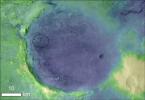
2010-02-11 |
Mars
|
Mars Reconnaissance Orbiter (MRO)
|
CRISM
HiRISE
|
1500x709x1 |
|
-
PIA12507:
-
Perspective View of Layered Mound in Gale Crater, Mars
Full Resolution:
TIFF
(1.065 MB)
JPEG
(89.06 kB)
|
|
|
2011-03-08 |
Mars
|
Mars Reconnaissance Orbiter (MRO)
|
CRISM
HiRISE
|
995x599x3 |
|
-
PIA13800:
-
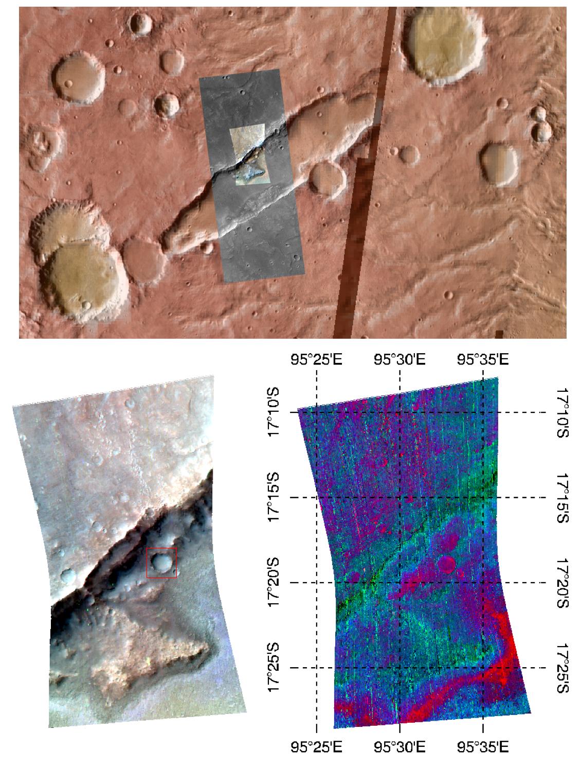
Fractures in Carbonate-Bearing Rocks at Mars' Huygens Basin
Full Resolution:
TIFF
(1.791 MB)
JPEG
(139 kB)
|
|
|
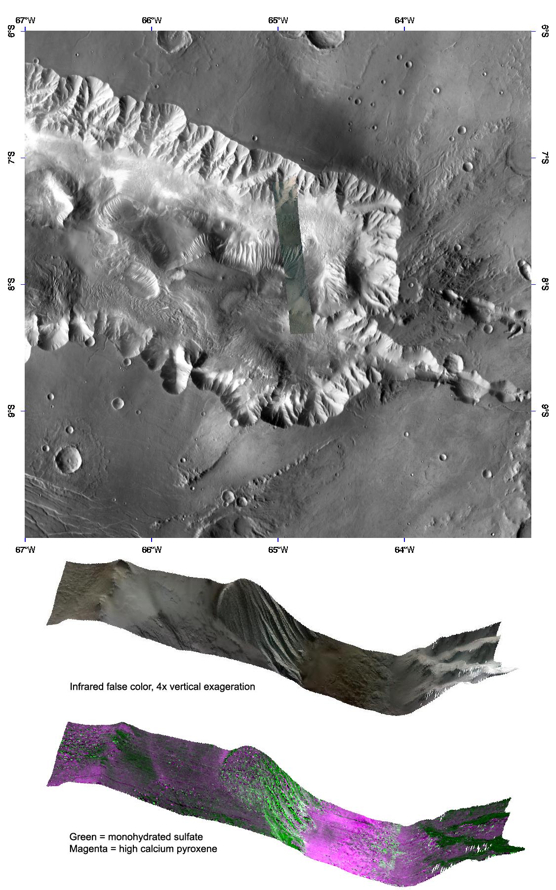
2015-09-02 |
Mars
|
Mars Reconnaissance Orbiter (MRO)
|
CRISM
HiRISE
|
801x1280x3 |
|
-
PIA19817:
-
Rocks Here Sequester Some of Mars' Early Atmosphere
Full Resolution:
TIFF
(3.077 MB)
JPEG
(333.9 kB)
|
|
|
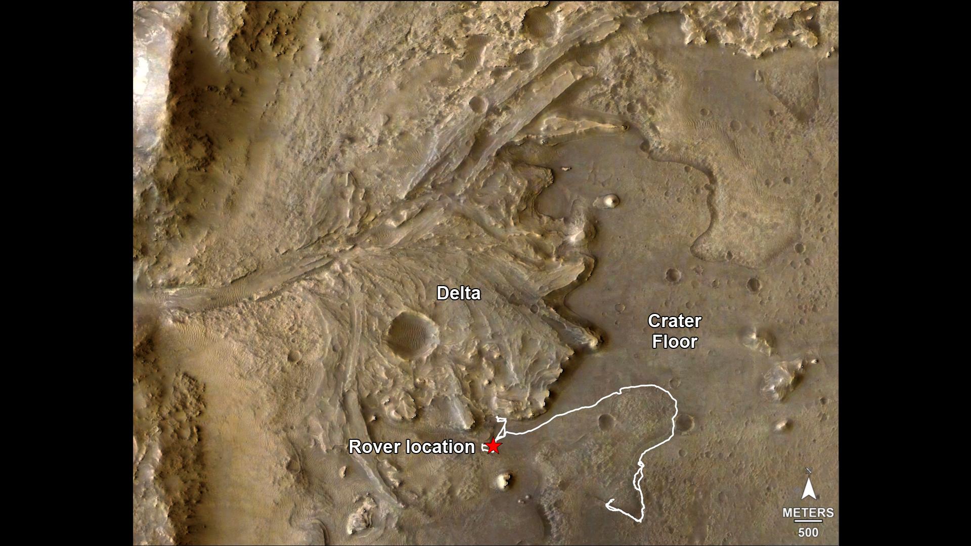
2022-09-15 |
Mars
|
Mars Reconnaissance Orbiter (MRO)
|
CRISM
HiRISE
|
1920x1080x3 |
|
-
PIA24922:
-
Perseverance's Route to the Delta
Full Resolution:
TIFF
(5.008 MB)
JPEG
(256 kB)
|
|
|
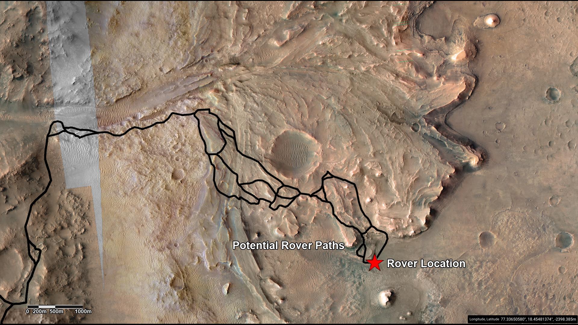
2022-09-15 |
Mars
|
Mars Reconnaissance Orbiter (MRO)
|
CRISM
HiRISE
|
1920x1080x3 |
|
-
PIA25244:
-
Potential Driving Routes for NASA's Perseverance Rover
Full Resolution:
TIFF
(6.223 MB)
JPEG
(406.8 kB)
|
|
|
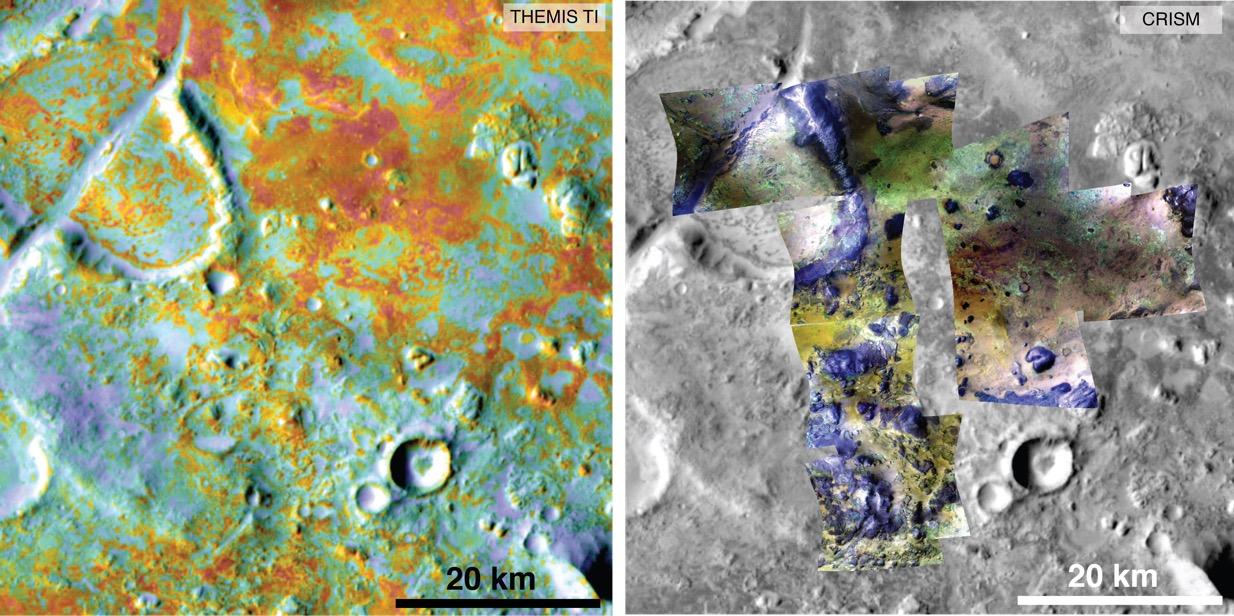
2015-09-02 |
Mars
|
2001 Mars Odyssey
Mars Reconnaissance Orbiter (MRO)
|
CRISM
THEMIS
|
1234x616x3 |
|
-
PIA19816:
-
Multiple Instruments Used for Mars Carbon Estimate
Full Resolution:
TIFF
(2.281 MB)
JPEG
(155.9 kB)
|
|
|
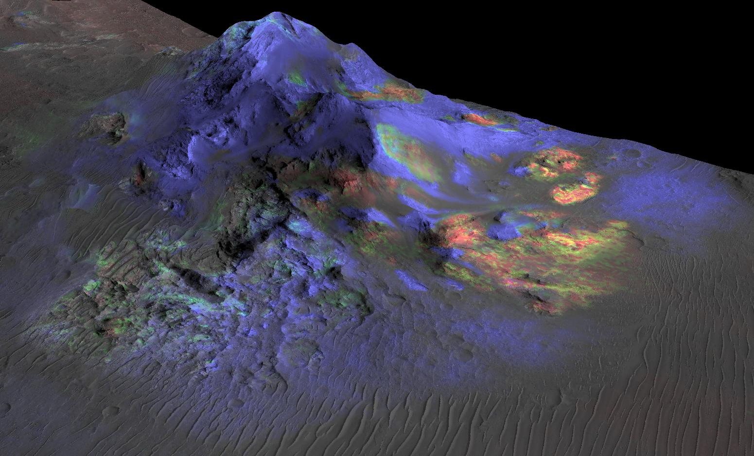
2016-05-03 |
Mars
|
2001 Mars Odyssey
Mars Reconnaissance Orbiter (MRO)
|
CRISM
THEMIS
|
758x747x3 |
|
-
PIA20335:
-
Evidence Builds for Old Under-Ice Volcanoes on Mars
Full Resolution:
TIFF
(943.9 kB)
JPEG
(110 kB)
|
|
|
2006-10-16 |
Mars
|
Mars Reconnaissance Orbiter (MRO)
|
CTX
|
1264x12544x1 |

|
-
PIA01930:
-
Context Camera Image of North Polar Chasma Boreale
Full Resolution:
TIFF
(15.87 MB)
JPEG
(611.2 kB)
|
|
|
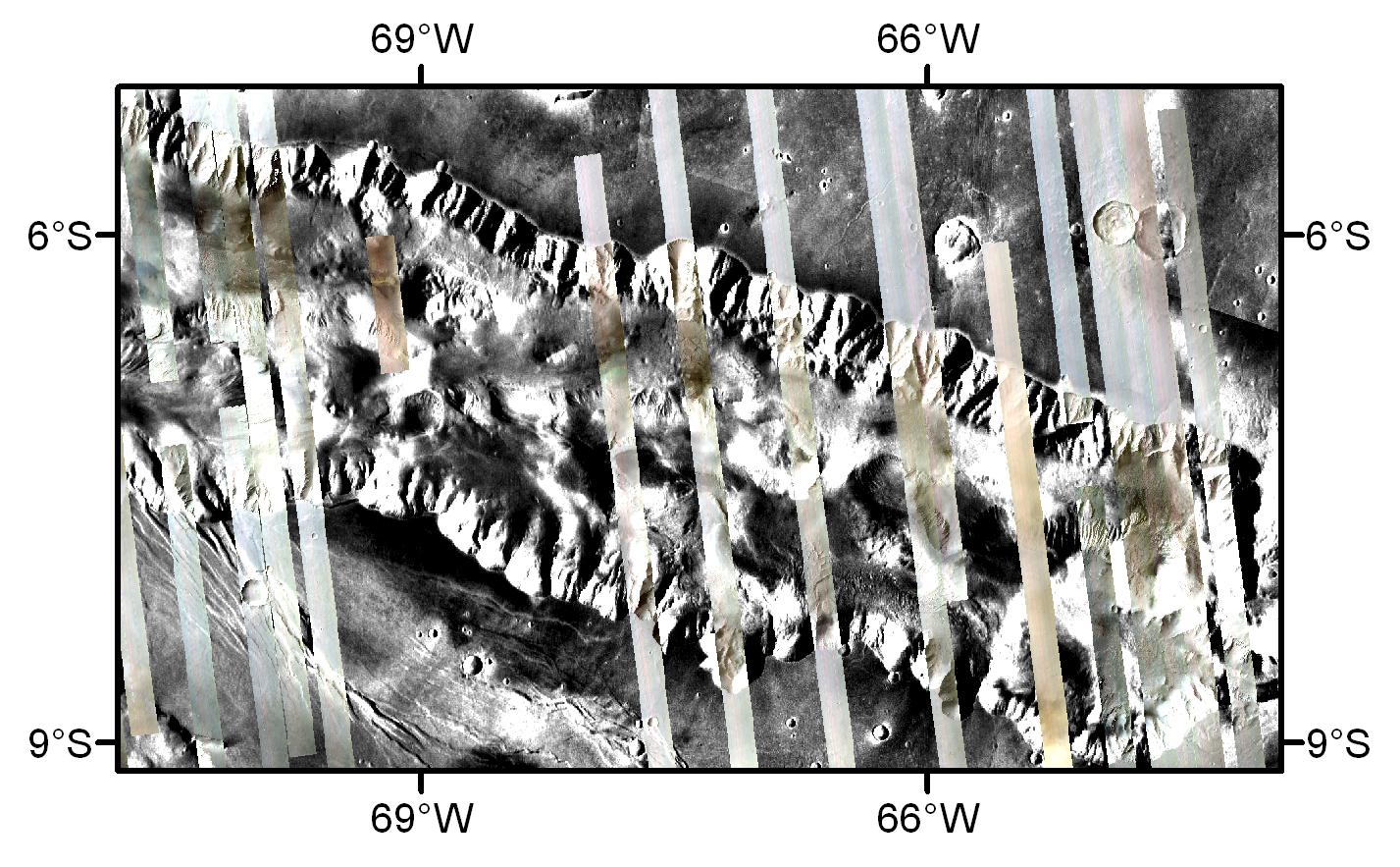
2006-10-16 |
Mars
|
Mars Reconnaissance Orbiter (MRO)
|
CTX
|
5056x7168x1 |
|
-
PIA01931:
-
Crater in Terra Sirenum with Gullied Walls
Full Resolution:
TIFF
(36.3 MB)
JPEG
(5.535 MB)
|
|
|
2006-10-16 |
Mars
|
Mars Reconnaissance Orbiter (MRO)
|
CTX
|
5056x12288x1 |
|
-
PIA01932:
-
Layered Rocks Near Mawrth Vallis
Full Resolution:
TIFF
(62.23 MB)
JPEG
(6.478 MB)
|
|
|
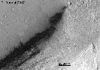
2007-08-02 |
Mars
|
Mars Reconnaissance Orbiter (MRO)
Phoenix
|
CTX
|
1159x858x3 |
|
-
PIA09946:
-
Possible Landing Ellipses for Phoenix
Full Resolution:
TIFF
(2.987 MB)
JPEG
(191.5 kB)
|
|
|
2007-08-02 |
Mars
|
Mars Reconnaissance Orbiter (MRO)
Phoenix
|
CTX
|
1300x1300x1 |
|
-
PIA09947:
-
Context Image of Planned Landing Site
Full Resolution:
TIFF
(1.692 MB)
JPEG
(108.2 kB)
|
|
|
2008-05-06 |
Mars
|
Mars Reconnaissance Orbiter (MRO)
|
CTX
|
499x5222x1 |

|
-
PIA10632:
-
Context Camera View in Phoenix Landing Region in Martian Arctic
Full Resolution:
TIFF
(2.609 MB)
JPEG
(328.2 kB)
|
|
|
2008-05-06 |
Mars
|
Mars Reconnaissance Orbiter (MRO)
|
CTX
|
4096x4096x1 |
|
-
PIA10633:
-
Context Camera Spots Dust Devils at Phoenix Landing Site
Full Resolution:
TIFF
(16.79 MB)
JPEG
(2.521 MB)
|
|
|
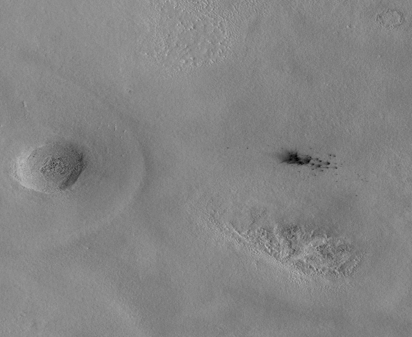
2009-03-18 |
Mars
|
Mars Reconnaissance Orbiter (MRO)
|
CTX
|
2000x1554x1 |

|
-
PIA11837:
-
Endeavour Crater in Context
Full Resolution:
TIFF
(3.111 MB)
JPEG
(298 kB)
|
|
|
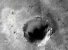
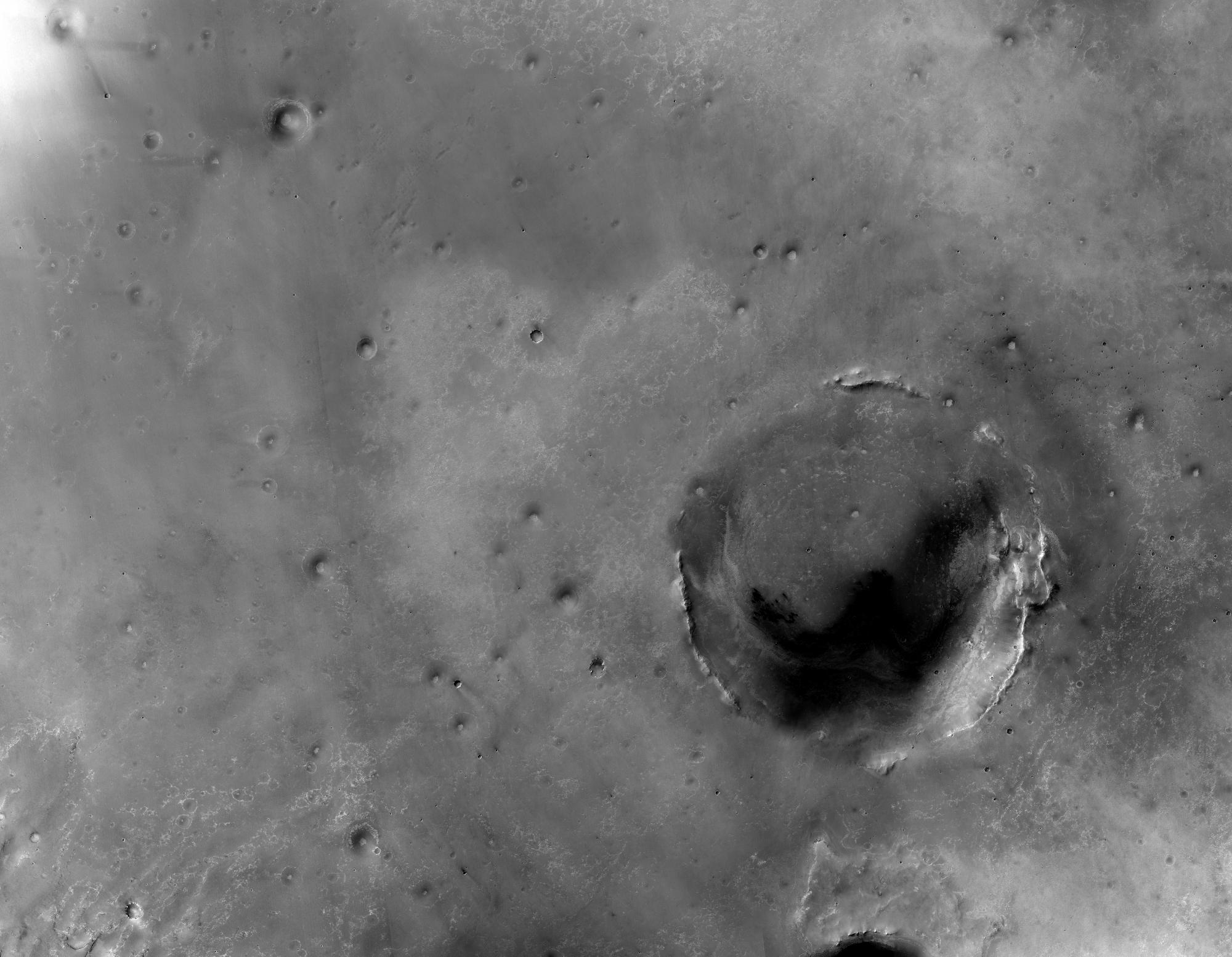
2009-09-24 |
Mars
|
Mars Reconnaissance Orbiter (MRO)
|
CTX
|
1338x1094x1 |
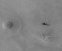
|
-
PIA12215:
-
New Impact Craters on Mars
Full Resolution:
TIFF
(1.465 MB)
JPEG
(183.8 kB)
|
|
|
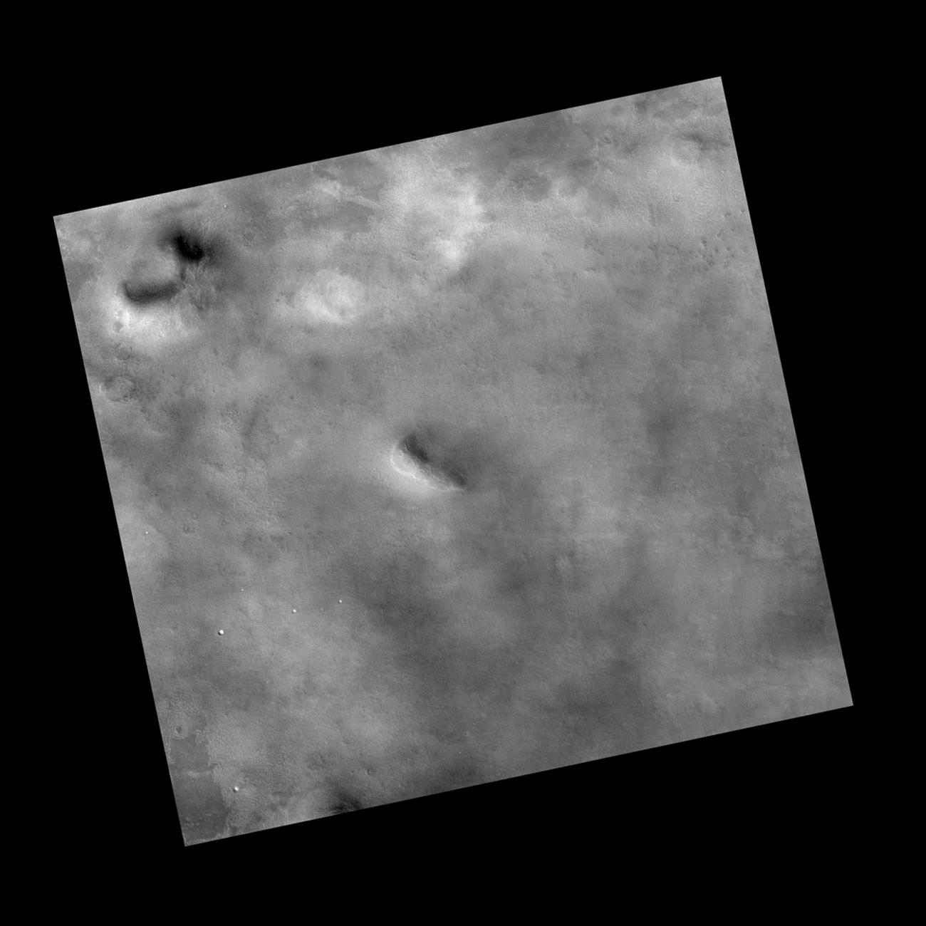
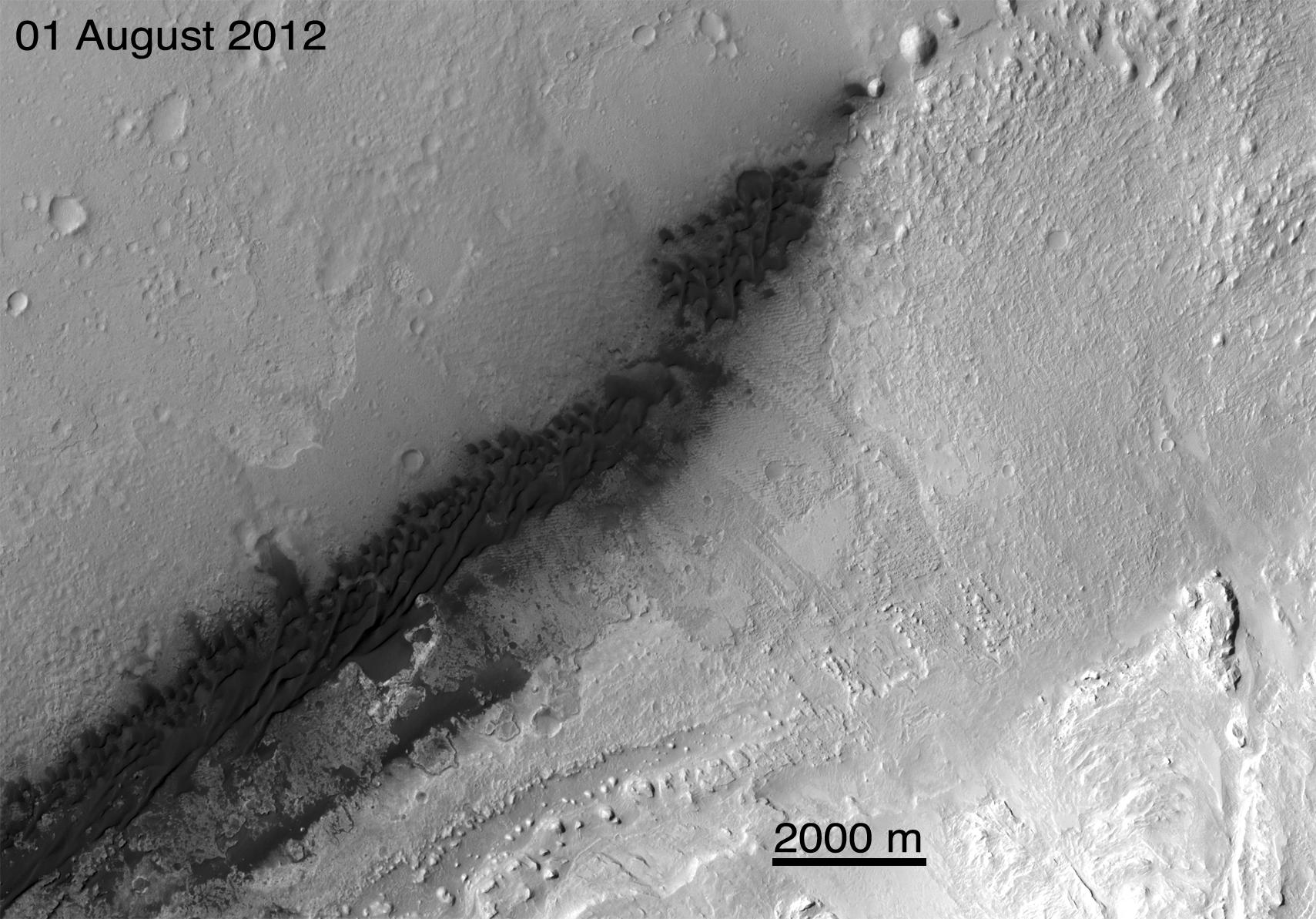
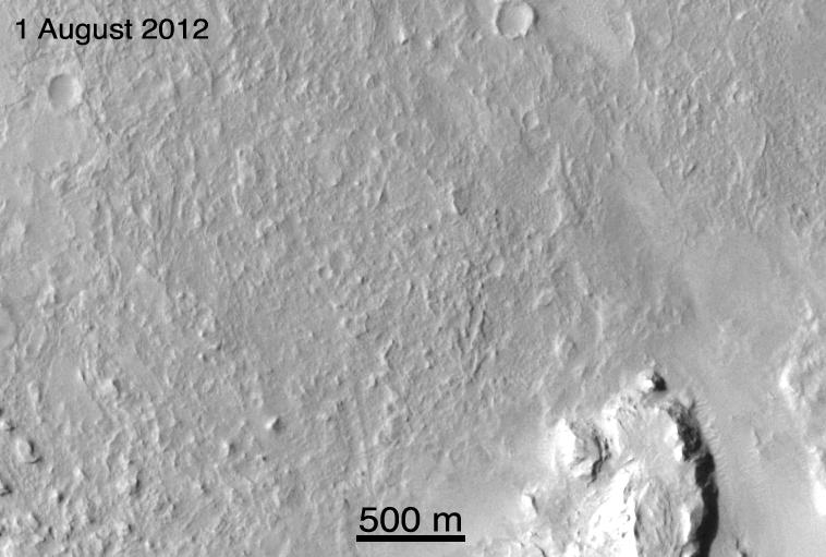
2010-03-04 |
Mars
|
Mars Reconnaissance Orbiter (MRO)
|
CTX
|
535x645x1 |
|
-
PIA12857:
-
Location Map for Images of Changing Martian Dunes
Full Resolution:
TIFF
(345.6 kB)
JPEG
(82.61 kB)
|
|
|
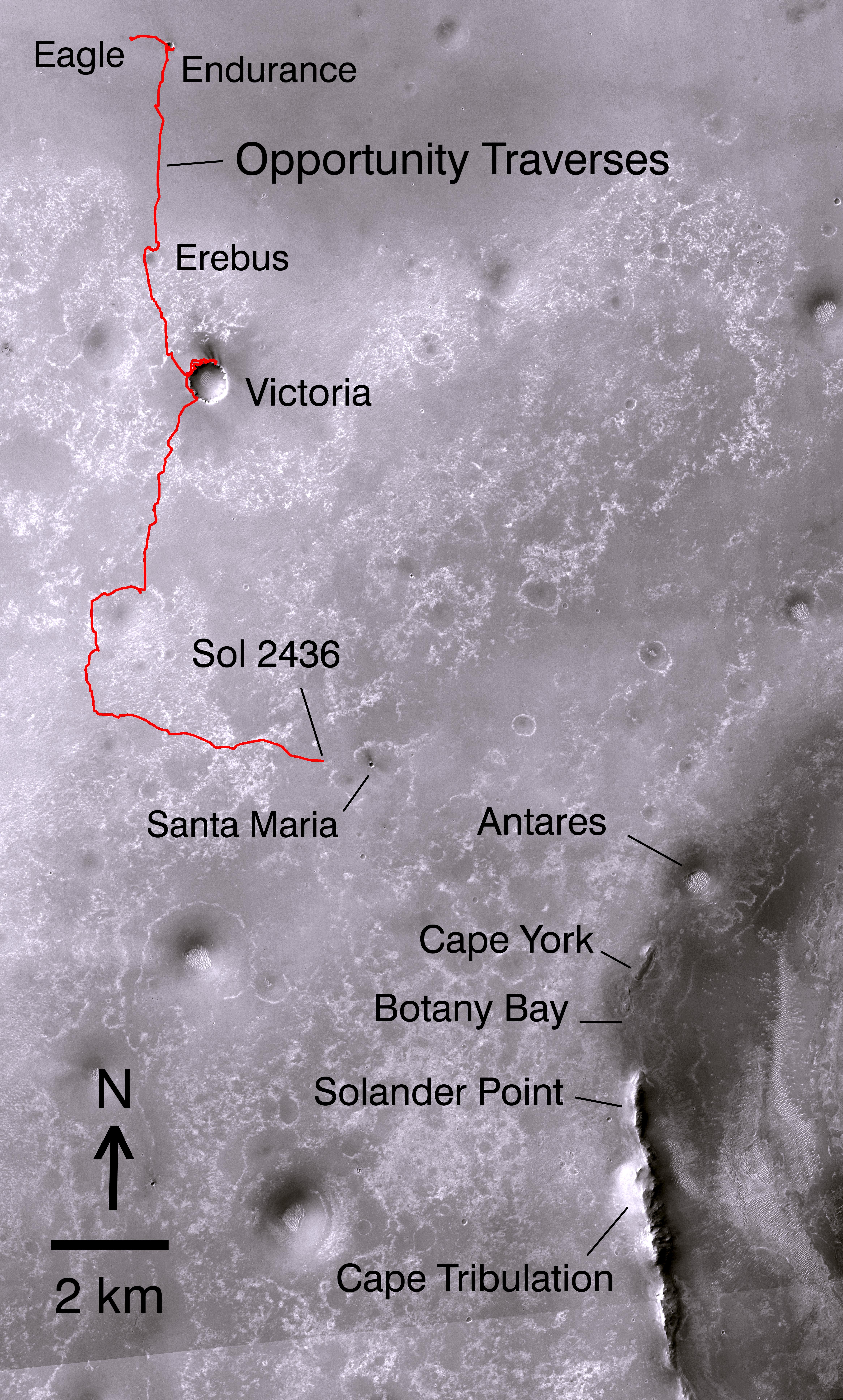
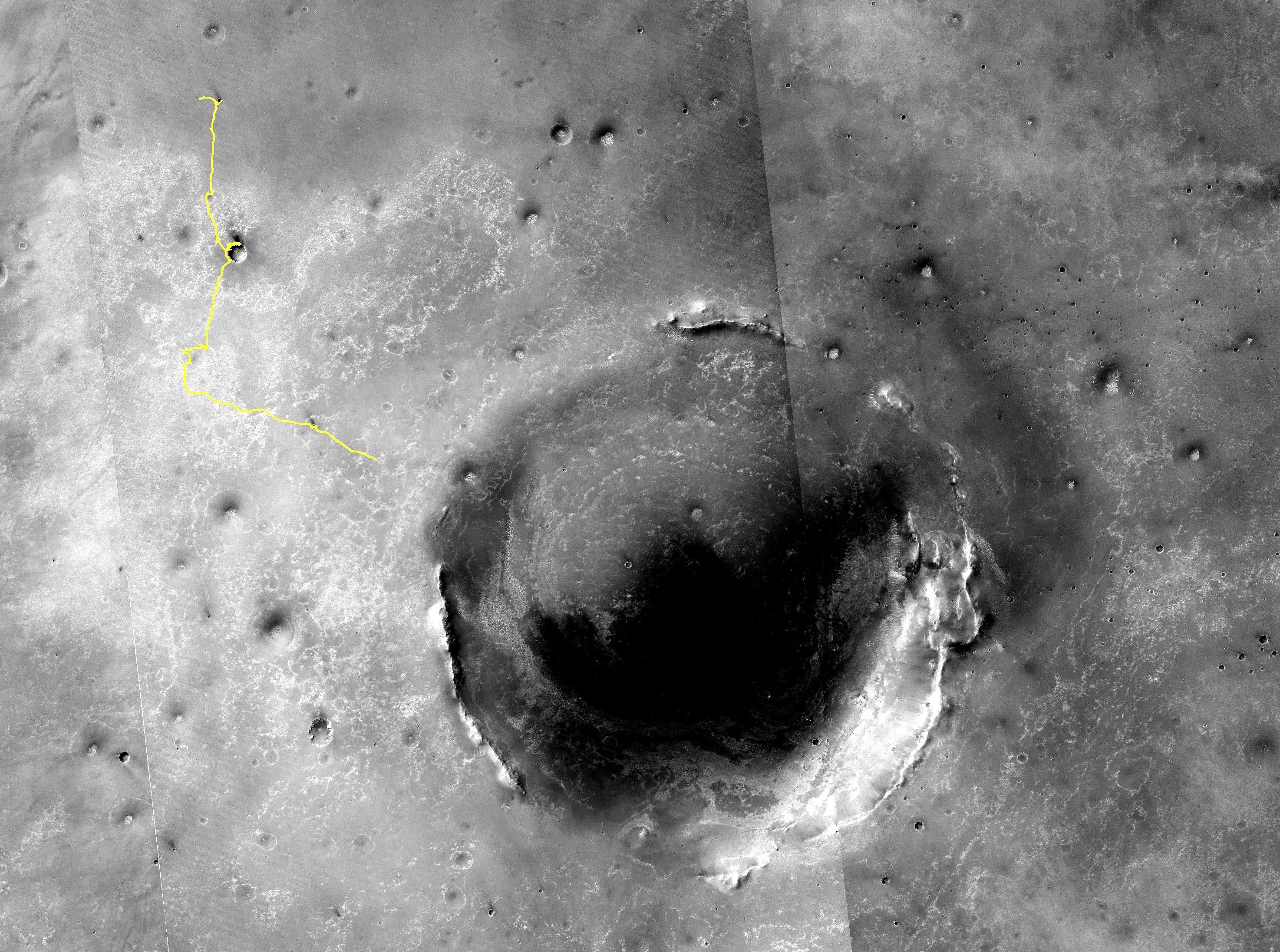
2010-12-16 |
Mars
|
Mars Reconnaissance Orbiter (MRO)
|
CTX
|
4664x7746x3 |

|
-
PIA13705:
-
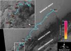
Opportunity's Path on Mars Through Sol 2436
Full Resolution:
TIFF
(108.4 MB)
JPEG
(5.199 MB)
|
|
|
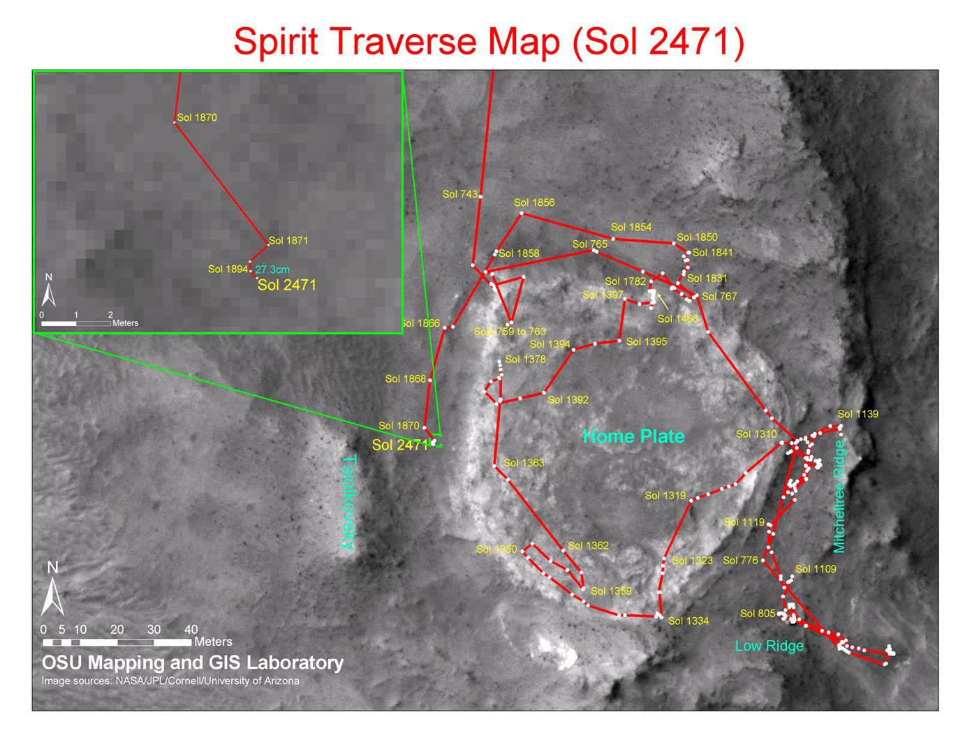
2010-12-17 |
Mars
|
Mars Exploration Rover (MER)
Mars Reconnaissance Orbiter (MRO)
|
CTX
|
1392x1080x3 |
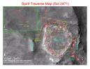
|
-
PIA13730:
-
Spirit Traverse Map, Sol 2471
Full Resolution:
TIFF
(4.519 MB)
JPEG
(176.5 kB)
|
|
|
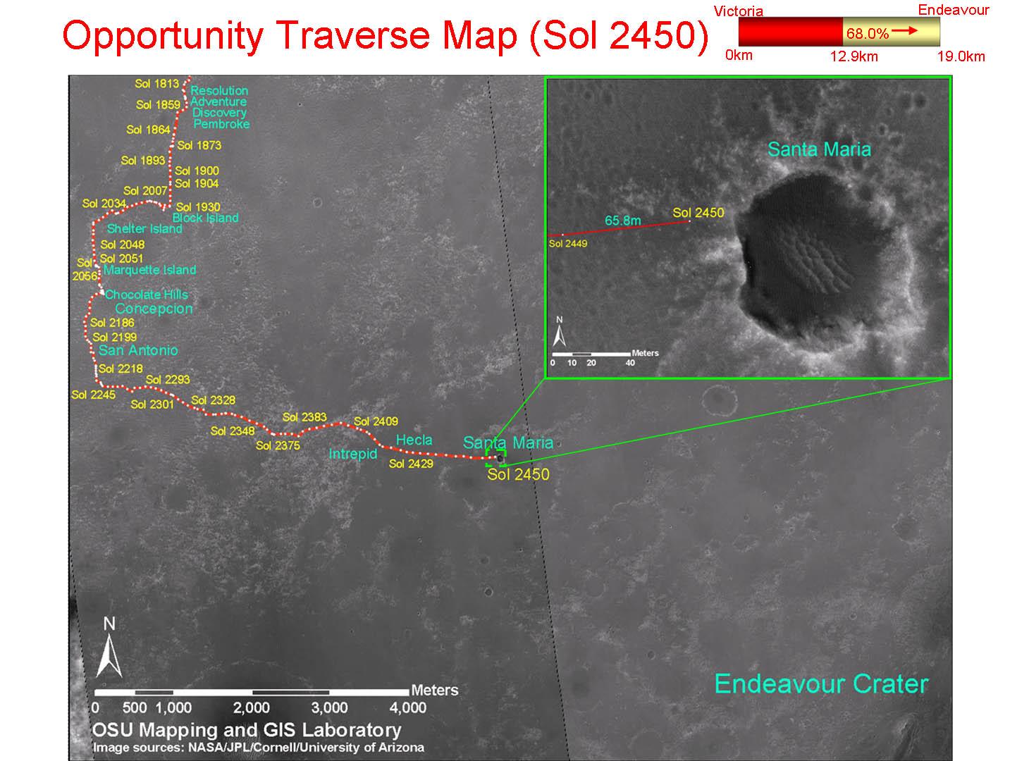
2010-12-17 |
Mars
|
Mars Exploration Rover (MER)
Mars Reconnaissance Orbiter (MRO)
|
CTX
|
1460x1080x3 |
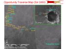
|
-
PIA13731:
-
Opportunity Traverse Map, Sol 2450
Full Resolution:
TIFF
(4.739 MB)
JPEG
(178 kB)
|
|
|
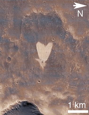
2011-02-14 |
Mars
|
Mars Reconnaissance Orbiter (MRO)
|
CTX
|
377x487x3 |
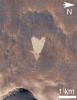
|
-
PIA13798:
-
Heart-Shaped Feature in Arabia Terra
Full Resolution:
TIFF
(185.6 kB)
JPEG
(41.39 kB)
|
|
|
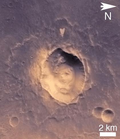
2011-02-14 |
Mars
|
Mars Reconnaissance Orbiter (MRO)
|
CTX
|
420x487x3 |

|
-
PIA13799:
-
Heart-Shaped Feature in Arabia Terra (Wide View)
Full Resolution:
TIFF
(206.5 kB)
JPEG
(25.93 kB)
|
|
|
2011-06-08 |
Mars
|
Mars Exploration Rover (MER)
Mars Reconnaissance Orbiter (MRO)
|
CTX
|
2948x2193x3 |
|
-
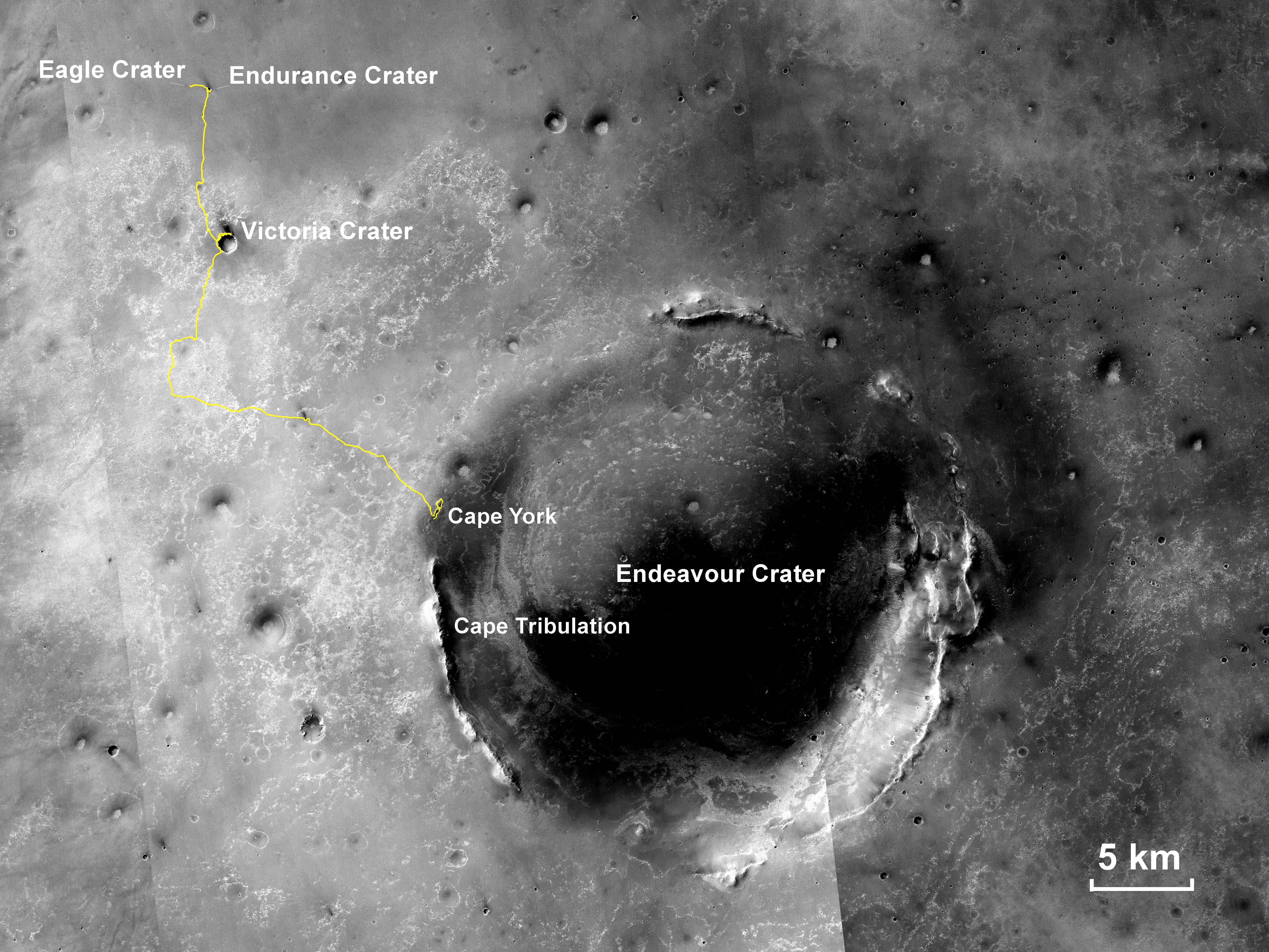
PIA14135:
-
Eagle to Endeavour: Opportunity's Path, Sol 2609
Full Resolution:
TIFF
(19.4 MB)
JPEG
(1.319 MB)
|
|
|
2011-09-01 |
Mars
|
Mars Exploration Rover (MER)
Mars Reconnaissance Orbiter (MRO)
|
CTX
|
5664x7979x3 |
|
-
PIA14536:
-
Opportunity Traverses Through 2,700 Martian Days
Full Resolution:
TIFF
(45.26 MB)
JPEG
(6.766 MB)
|
|
|
2012-08-08 |
Mars
|
Mars Reconnaissance Orbiter (MRO)
Mars Science Laboratory (MSL)
|
CTX
|
1709x1193x1 |
|
-
PIA16014:
-
Before and After Curiosity's Touchdown
Full Resolution:
TIFF
(2.041 MB)
JPEG
(305.4 kB)
|
|
|
2012-08-08 |
Mars
|
Mars Reconnaissance Orbiter (MRO)
Mars Science Laboratory (MSL)
|
CTX
|
758x511x1 |
|
-
PIA16016:
-
Ballasts Hitting the Surface, Close-Up
Full Resolution:
TIFF
(388 kB)
JPEG
(58 kB)
|
|
|
2012-08-08 |
Mars
|
Mars Reconnaissance Orbiter (MRO)
Mars Science Laboratory (MSL)
|
CTX
|
758x511x1 |

|
-
PIA16015:
-
Ballasts Hitting the Surface, Close-Up (with arrows)
Full Resolution:
TIFF
(388 kB)
JPEG
(58.05 kB)
|
|
|
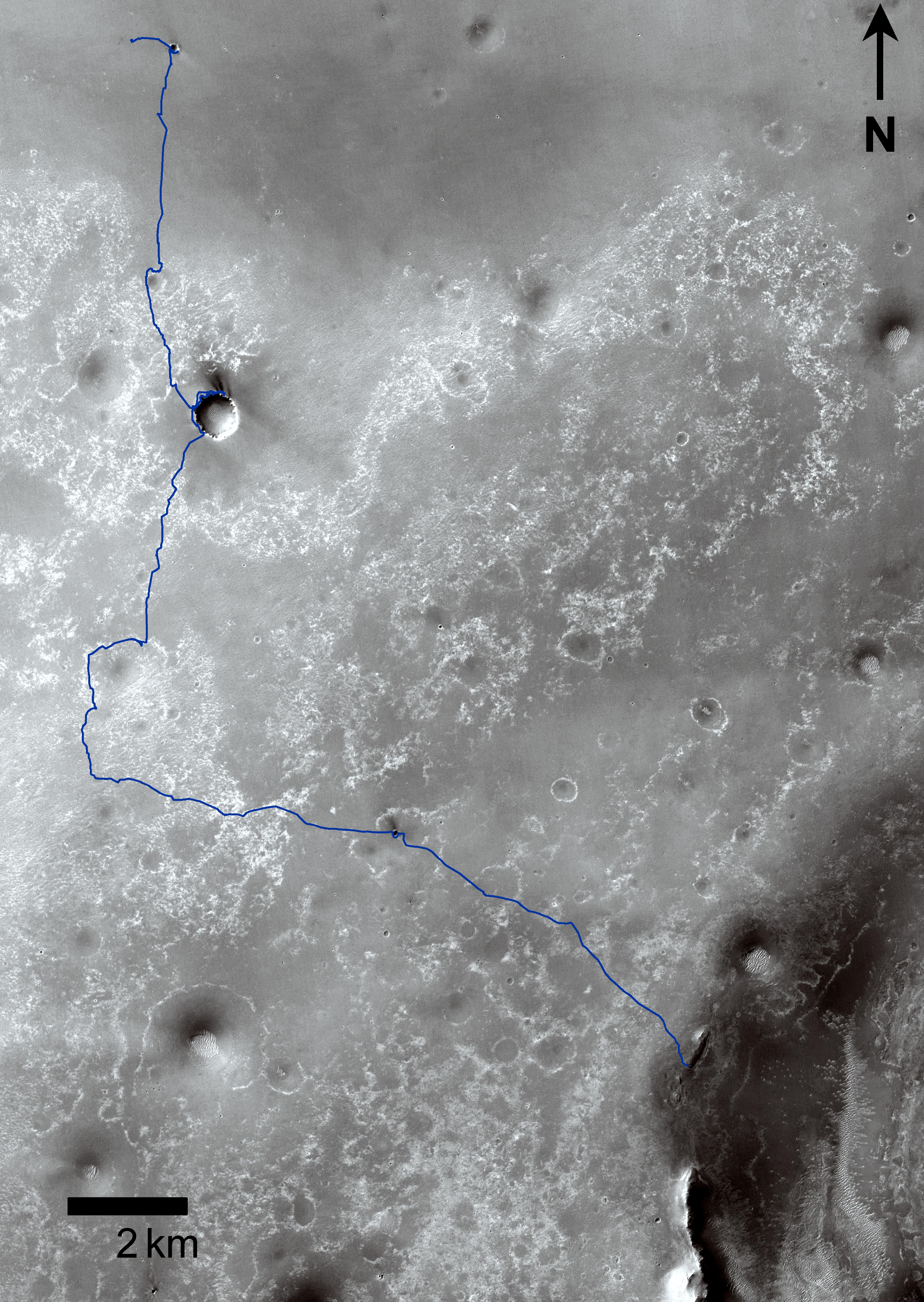
2013-06-07 |
Mars
|
Mars Exploration Rover (MER)
Mars Reconnaissance Orbiter (MRO)
|
CTX
|
5198x3900x3 |
|
-
PIA17070:
-
Opportunity's Traverse Through 112 Months
Full Resolution:
TIFF
(60.85 MB)
JPEG
(3.973 MB)
|


