My Favorite Images from the Planetary Photojoural
I have 4 images in my list


The first time you select an image to My List, a separate browser window will open. This page will list the set of images you have selected as favorites from the Photojournal. This list is kept for a short period of time, approximately 60 days. The way we associate you with your list is through a persistent cookie left on your computer. This cookie is nothing more than a unique key that allows the Photojournal to make this association. Once created, this list is only modifiable from the same computer. Information stored in the cookie on your computer is used by the Photojournal server only during your session. If you configure your Web browser not to use cookies, you will not be able to create and refer back to a personal list of favorite images. To view your current list, click on a marked entry for your list from the catalog page, or add another favorite. For more information, see JPL's Privacy Policy.
My
List
Catalog # Target Mission Instrument Addition Date Size
Remove Image from Favorite List PIA03349 Earth Shuttle Radar Topography Mission (SRTM)
C-Band Interferometric Radar
2002-04-22 7200x7200x3
The Bosporus (also spelled Bosphorus) is a strait that connects the Black Sea with the Sea of Marmara in the center of this view of northwest Turkey, taken during NASA's Shuttle Radar Topography Mission.
Title:
Shaded Relief and Radar Image with Color as Height, Bosporus Strait and Istanbul, Turkey
Remove Image from Favorite List PIA03351 Earth Shuttle Radar Topography Mission (SRTM)
C-Band Interferometric Radar
2002-07-11 7200x3601x3
Volcanic, tectonic, erosional and sedimentary landforms are all evident in these images from NASA's Shuttle Radar Topography Mission of a region along the East African Rift at Lake Kivu. The area shown covers parts of Congo, Rwanda and Uganda.
Title:
Shaded Relief with Height as Color, Virunga and Nyiragongo Volcanoes and the East African Rift Valley
Remove Image from Favorite List PIA03342 Earth Landsat
Shuttle Radar Topography Mission (SRTM)
C-Band Interferometric Radar
Thematic Mapper
2002-02-06 3100x553x3
Most of the population of Utah lives just west of the Wasatch Mountains in the north central part of the state. This image is from NASA's Shuttle Radar Topography Mission.
Title:
Perspective View with Landsat Overlay, Salt Lake City, Utah
Remove Image from Favorite List PIA03446 Earth Terra
MISR
2002-02-27 2034x1128x3
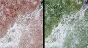
These images of Canada's Québec province were acquired by NASA's Terra satelliteon March 4, 2001.The region's forests are a mixture of coniferous and hardwood trees, and 'sugar-shack' festivities are held at this time of year to celebrate the beginning o
Title:
Southern Québec in Late Winter