Annotated Version
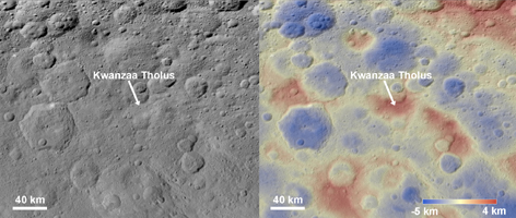
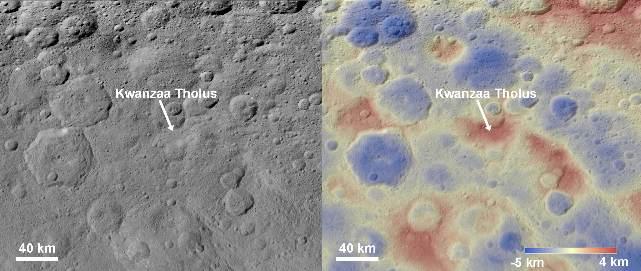
Click on the image for larger versionThese images show a subtle feature on Ceres called Kwanzaa Tholus. Kwanzaa, meaning "first fruits" in Swahili, is an African-American festival based on ancient African harvest celebrations, and takes place from December 26 to January 1.
A tholus is a type of small mountain. Kwanzaa Tholus measures about 22 by 12 miles (35 by 19 kilometers) and is elevated about 2 miles (3 km) above its surroundings. Because the mountain does not rise sharply above the ground, it is difficult to see in the mosaic on the left, although a small crescent-shaped shadow stands out. The image on the right, which is an elevation map of the area, shows where Kwanzaa Tholus is more prominently.
The rounded shape of Kwanzaa Tholus is typical of tholi (plural of tholus) in general, but is different than other examples found on Ceres (like Dalien Tholus) and Mars. This region is particularly rich in this type of feature: The current Ceres map shows six named tholi and montes (slightly bigger mountains) in the region (centered around 32 degrees north, 327 degrees east) and several others including Ahuna Mons farther south.
Scientists say Kwanzaa Tholus may have once been as prominent as Ahuna Mons, the tallest and most noticeable mountain on Ceres. Ahuna Mons is likely a cryovolcano, a volcano formed by the gradual accumulation of thick, slowly flowing icy materials. Because ice is not strong enough to preserve an elevated structure for extended periods, cryovolcanoes on Ceres are expected to gradually collapse over tens of millions of years. This means Kwanzaa Tholus and other tholi in that area could be degraded mountains, which also formed from cryovolcanic activity.
The mosaic on the left combines images taken by NASA's Dawn spacecraft in its high-altitude mapping orbit (HAMO) at about 915 miles (1,470 kilometers) above the surface. The spatial resolution is 450 feet (140 meters) per pixel.
Dawn's mission is managed by JPL for NASA's Science Mission Directorate in Washington. Dawn is a project of the directorate's Discovery Program, managed by NASA's Marshall Space Flight Center in Huntsville, Alabama. UCLA is responsible for overall Dawn mission science. Orbital ATK Inc., in Dulles, Virginia, designed and built the spacecraft. The German Aerospace Center, Max Planck Institute for Solar System Research, Italian Space Agency and Italian National Astrophysical Institute are international partners on the mission team.
For a complete list of Dawn mission participants, visit http://dawn.jpl.nasa.gov/mission.
For more information about the Dawn mission, visit http://dawn.jpl.nasa.gov.