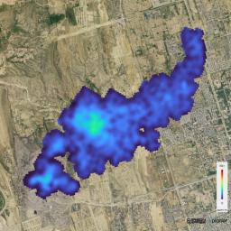
The Carbon Mapper Coalition's Tanager-1 satellite on Sept. 19, 2024, captured data over Karachi, Pakistan, showing the location and concentration of a methane plume measuring about 2½ miles (4 kilometers) long, emanating from a landfill. Enabled by the nonprofit Carbon Mapper and built by Planet Labs PBC, Tanager-1 uses an imaging spectrometer designed by NASA's Jet Propulsion Laboratory in Southern California. Carbon Mapper's preliminary estimate of the source emissions rate is about 2,600 pounds (1,200 kilograms) of methane released per hour.
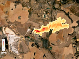
Figure A shows data Tanager-1 collected Sept. 19, 2024, over Kendal, South Africa, indicting a nearly 2-mile-long (3-kilometer-long) carbon dioxide plume coming from a coal-fired power plant. Carbon Mapper's preliminary estimate of the source emissions rate is roughly 1.3 million pounds (600,000 kilograms) of carbon dioxide per hour.

Figure A
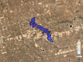
Click on the image for larger versionFigure B shows data Tanager-1 collected Sept. 24, 2024, revealing a methane plume south of Midland, Texas, in the Permian Basin, one of the largest oilfields in the world. Carbon Mapper's preliminary estimate of the source emissions rate is about 900 pounds (400 kilograms) of methane per hour.

Figure B
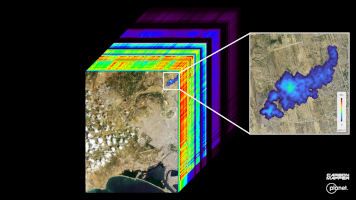
Click on the image for larger versionFigure C shows the Karachi scene in addition to an image cube. The image at the front of the cube shows the location of the landfill-based methane plume in broader context, as well as information on land cover and water in the city and surrounding area, including exposed soil (brown), vegetation (green), and clouds. The rainbow colors extending through the main part of the cube are the wavelengths of light from corresponding spots in the front image.

Figure C
Click on the image for larger versionLaunched from Vandenberg Space Force Base in California on Aug. 16, 2024, Tanager-1 is part of a broader effort by the nonprofit Carbon Mapper to identify and measure greenhouse gas point-source emissions on a global scale. Both Planet and JPL are members of the philanthropically funded Carbon Mapper Coalition.

 Planetary Data System


