Click here for Figure A animation (.mp4, 201 MB)
Click here for Figure B animation (.gif, 275 KB)
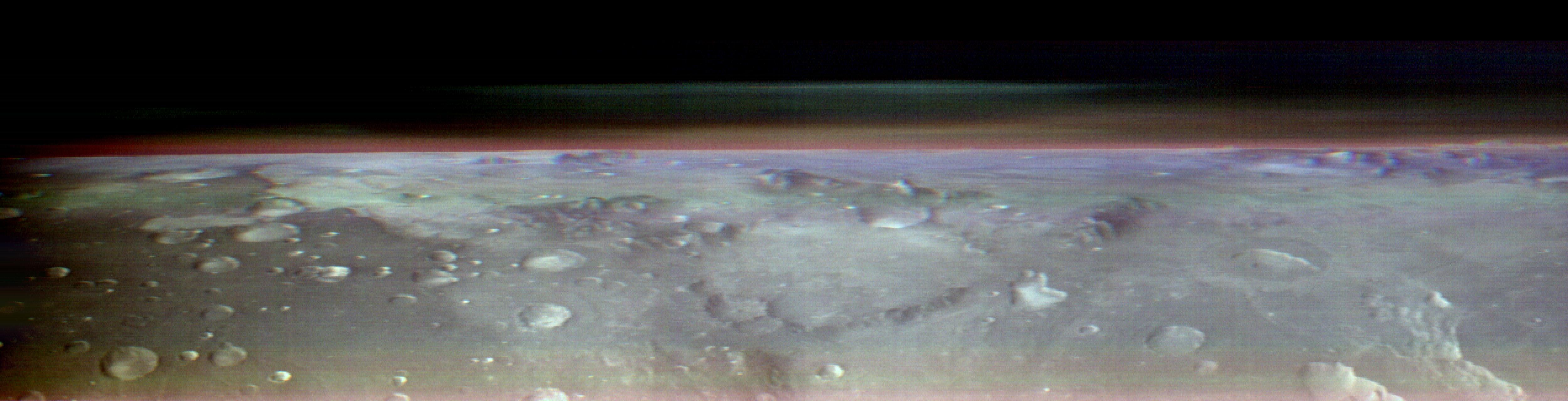
This view of Mars was captured by NASA's Odyssey orbiter using its Thermal Emission Imaging System, or THEMIS, camera. This image is a false color composite, made by combining three channels of infrared data that highlight water-ice clouds and dust in the atmosphere. This panorama was one of 10 captured on May 9, 2023, from an altitude of roughly 250 miles (400 kilometers) above the Martian surface – about the same altitude at which the International Space Station flies over Earth.
Figure A is a video that pans across four of the 10 panoramas placed side by side, with notable regions of Mars labeled: eastern Hellas basin, Arcadia Planitia, Utopia Planitia, Nili Fossae, and Syrtis Major. The images are in black and white, including the panorama seen above where three color channels were combined.
Figure B is an animated series of images showing Phobos, one of Mars' two moons, moving across the sky. Phobos was also imaged as Odyssey was pointed towards the horizon.
The 10 panoramas of the Martian horizon were taken to capture a one-of-a-kind view of the Martian atmosphere as Odyssey circled the planet during its two-hour orbit. The reason why the view is so uncommon is because of the challenges involved in creating it. Engineers at NASA's Jet Propulsion Laboratory in Southern California (which leads the Odyssey mission) and Lockheed Martin Space (which built Odyssey and co-leads day-to-day operations) spent three months planning the observations. THEMIS' sensitivity to warmth enables it to map ice, rock, sand, and dust, along with temperature changes, on the planet's surface. It can also measure how much water ice or dust is in the atmosphere, but only in a narrow column directly below the spacecraft. That's because THEMIS is fixed in place on the orbiter; it usually points straight down.
Mission scientists wanted a more expansive view of the atmosphere. Seeing where those layers of water-ice clouds and dust are in relation to each other – whether there's one layer or several stacked on top of each other – helps them improve models of Mars' atmosphere.
Because THEMIS can't pivot, adjusting the angle of the camera requires adjusting the position of the whole spacecraft. In this case, the team needed to rotate the orbiter almost 90 degrees while making sure the Sun would still shine on the spacecraft's solar panels but not on sensitive equipment that could overheat. The easiest orientation turned out to be one where the orbiter's antenna pointed away from Earth. That meant the team was out of communication with Odyssey for several hours until the operation was completed.
THEMIS was built and is operated by Arizona State University in Tempe.
More about Odyssey: https://mars.nasa.gov/odyssey/
 Planetary Data System


