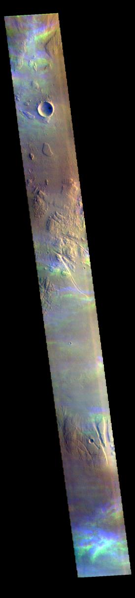
Context imageThe THEMIS VIS camera contains 5 filters. The data from different filters can be combined in multiple ways to create a false color image. These false color images may reveal subtle variations of the surface not easily identified in a single band image. Today's false color image shows high altitude ice clouds. The blue and yellow bands in this image are not image artifacts, but are the traces of ice rich clouds. Each framelet of the image is collected at slightly different times. For the unchanging surface, this works fine. Optically thick dust clouds are usually close to the surface so any motion of the clouds is not dramatic as seen from the altitude of the Odyssey spacecraft. Transparent, and high altitude clouds are harder to discern in single band images – but are easy to discern in false color images – the clouds are in slightly different positions as each filter is collected. The clouds in this image are in the Tharsis region. Clouds are common there in the northern spring season. As clouds are a transient process, they can not be targeted, but are a 'surprise' when they are captured in an image.
The THEMIS VIS camera is capable of capturing color images of the Martian surface using five different color filters. In this mode of operation, the spatial resolution and coverage of the image must be reduced to accommodate the additional data volume produced from using multiple filters. To make a color image, three of the five filter images (each in grayscale) are selected. Each is contrast enhanced and then converted to a red, green, or blue intensity image. These three images are then combined to produce a full color, single image. Because the THEMIS color filters don't span the full range of colors seen by the human eye, a color THEMIS image does not represent true color. Also, because each single-filter image is contrast enhanced before inclusion in the three-color image, the apparent color variation of the scene is exaggerated. Nevertheless, the color variation that does appear is representative of some change in color, however subtle, in the actual scene. Note that the long edges of THEMIS color images typically contain color artifacts that do not represent surface variation.
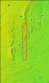
Orbit Number: 94128 Latitude: 14.3145 Longitude: 281.365 Instrument: VIS Captured: 2023-03-04 19:22
Please see the THEMIS Data Citation Note for details on crediting THEMIS images.
NASA's Jet Propulsion Laboratory manages the 2001 Mars Odyssey mission for NASA's Science Mission Directorate, Washington, D.C. The Thermal Emission Imaging System (THEMIS) was developed by Arizona State University, Tempe, in collaboration with Raytheon Santa Barbara Remote Sensing. The THEMIS investigation is led by Dr. Philip Christensen at Arizona State University. Lockheed Martin Astronautics, Denver, is the prime contractor for the Odyssey project, and developed and built the orbiter. Mission operations are conducted jointly from Lockheed Martin and from JPL, a division of the California Institute of Technology in Pasadena.
 Planetary Data System


