PDS logoPlanetary Data System
PDS Information
Find a Node - Use these links to navigate to any of the 8 publicly accessible PDS Nodes.

This bar indicates that you are within the PDS enterprise which includes 6 science discipline nodes and 2 support nodes which are overseen by the Project Management Office at NASA's Goddard Space Flight Center (GSFC). Each node is led by an expert in the subject discipline, supported by an advisory group of other practitioners of that discipline, and subject to selection and approval under a regular NASA Research Announcement.
Click here to return to the Photojournal Home Page Click here to view a list of Photojournal Image Galleries Photojournal_inner_header
Latest Images  |  Spacecraft & Technology  |  Animations  |  Space Images App  |  Feedback  |  Photojournal Search  

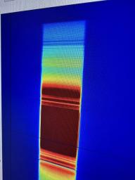
PIA26096: Imaging Spectrometer Instrument's Data Shows Methane Intensity
 Mission:  Carbon Mapper 
 Spacecraft:  Tanager-1
 Instrument:  Carbon Mapper Imaging Spectrometer 
 Product Size:  3024 x 4032 pixels (w x h)
 Produced By:  JPL
 Full-Res TIFF:  PIA26096.tif (29.68 MB)
 Full-Res JPEG:  PIA26096.jpg (1.645 MB)

Click on the image above to download a moderately sized image in JPEG format (possibly reduced in size from original)

Original Caption Released with Image:

The data captured here is one of the outputs of a September 2023 test conducted at NASA's Jet Propulsion Laboratory of a state-of-the-art imaging spectrometer instrument, which will measure the greenhouse gases methane and carbon dioxide from space. The instrument successfully detected the presence of methane (dark blue line near the top of the rainbow band), a greenhouse gas, in a sample cylinder.

The rainbow band shown on a screen here is a measure of the intensity of a spectrum of light. Blue is low intensity and red is high intensity.

Designed and built by JPL, imaging spectrometer will be part of an effort led by the nonprofit Carbon Mapper organization to collect data on greenhouse gas point-source emissions. The information will help locate and quantify "super-emitters" – the small percentage of individual sources responsible for a significant fraction of methane and carbon dioxide emissions around the world.

The organization is leading the development of the Carbon Mapper constellation of satellites supported by a public-private partnership composed of Planet Labs PBC, JPL, the California Air Resources Board, the University of Arizona, Arizona State University, and RMI, with funding from High Tide Foundation, Bloomberg Philanthropies, Grantham Foundation for the Protection of the Environment, and other philanthropic donors.

Image Credit:
NASA/JPL-Caltech

Image Addition Date:
2023-09-14