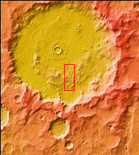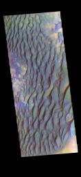
Context imageThe THEMIS VIS camera contains 5 filters. The data from different filters can be combined in multiple ways to create a false color image. These false color images may reveal subtle variations of the surface not easily identified in a single band image. Today's false color image shows part of the floor of Kaiser Crater. Kaiser Crater is 207 km (129 miles) in diameter and is located in Noachis Terra west of Hellas Planitia. This sand dune field is one of several regions of sand dunes located on the southern part of the crater floor. The image also shows the complex crater floor beneath the dunes. These dunes are composed of basaltic sand that has collected in the bottom of the crater. The topographic depression of the crater forms a sand trap that prevents the sand from escaping. Dune fields are common in the bottoms of craters on Mars and appear as dark splotches that often lean up against the downwind walls of the craters. Dunes are useful for studying both the geology and meteorology of Mars. The sand forms by erosion of larger rocks, but it is unclear when and where this erosion took place on Mars or how such large volumes of sand could be formed. The dunes also indicate the local wind directions by their morphology. In this case, there are few clear slipfaces that would indicate the downwind direction. The crests of the dunes also typically run north-south in the image. This dune form indicates that there are probably two prevailing wind directions that run east and west (left to right and right to left).
The THEMIS VIS camera is capable of capturing color images of the Martian surface using five different color filters. In this mode of operation, the spatial resolution and coverage of the image must be reduced to accommodate the additional data volume produced from using multiple filters. To make a color image, three of the five filter images (each in grayscale) are selected. Each is contrast enhanced and then converted to a red, green, or blue intensity image. These three images are then combined to produce a full color, single image. Because the THEMIS color filters don't span the full range of colors seen by the human eye, a color THEMIS image does not represent true color. Also, because each single-filter image is contrast enhanced before inclusion in the three-color image, the apparent color variation of the scene is exaggerated. Nevertheless, the color variation that does appear is representative of some change in color, however subtle, in the actual scene. Note that the long edges of THEMIS color images typically contain color artifacts that do not represent surface variation.
Orbit Number: 91442 Latitude: -46.9777 Longitude: 19.5189 Instrument: VIS Captured: 2022-07-26 15:07
Please see the THEMIS Data Citation Note for details on crediting THEMIS images.
NASA's Jet Propulsion Laboratory manages the 2001 Mars Odyssey mission for NASA's Science Mission Directorate, Washington, D.C. The Thermal Emission Imaging System (THEMIS) was developed by Arizona State University, Tempe, in collaboration with Raytheon Santa Barbara Remote Sensing. The THEMIS investigation is led by Dr. Philip Christensen at Arizona State University. Lockheed Martin Astronautics, Denver, is the prime contractor for the Odyssey project, and developed and built the orbiter. Mission operations are conducted jointly from Lockheed Martin and from JPL, a division of the California Institute of Technology in Pasadena.

 Planetary Data System


