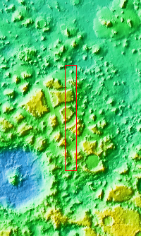
Context imageThe mesas and valleys in this VIS image are part of Protonilus Mensae. Located between the relative highlands of northern Terra Sabaea and the lowlands of Vastitas Borealis, Protonilus Mensae is region of chaos terrain. Chaos terrain is typified by regions of blocky, often steep sided, mesas interspersed with deep valleys. With time and erosion the valleys widen and the mesas become smaller. It has been proposed that a catastrophic outflow of subsurface water creates the chaos. Protonilus Mensae also shows signs of glacial flows, which would continue to modify the surface.
Orbit Number: 93930 Latitude: 43.4172 Longitude: 47.0895 Instrument: VIS Captured: 2023-02-16 12:47
Please see the THEMIS Data Citation Note for details on crediting THEMIS images.
NASA's Jet Propulsion Laboratory manages the 2001 Mars Odyssey mission for NASA's Science Mission Directorate, Washington, D.C. The Thermal Emission Imaging System (THEMIS) was developed by Arizona State University, Tempe, in collaboration with Raytheon Santa Barbara Remote Sensing. The THEMIS investigation is led by Dr. Philip Christensen at Arizona State University. Lockheed Martin Astronautics, Denver, is the prime contractor for the Odyssey project, and developed and built the orbiter. Mission operations are conducted jointly from Lockheed Martin and from JPL, a division of the California Institute of Technology in Pasadena.
