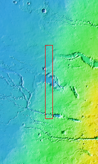
Context imageToday's VIS image contains a section of one of the many channel forms found radial to the Elysium Mons volcanic complex. In this case the fossae are located to the west of Elysium Mons. Elysium Fossae are comprised of both linear and sinuous channels, usually interpreted to have both fluid and tectonic forces playing a part in the formation. The linear depression resembles a graben (formed by tectonic forces) and sinuous channels more closely resembles features caused by fluid flow – either lava or water created by melting subsurface ice due to volcanic heating. The Elysium Fossae system is 1044 km (649 miles) in length.
Orbit Number: 93802 Latitude: 27.5316 Longitude: 137.172 Instrument: VIS Captured: 2023-02-05 23:55
Please see the THEMIS Data Citation Note for details on crediting THEMIS images.
NASA's Jet Propulsion Laboratory manages the 2001 Mars Odyssey mission for NASA's Science Mission Directorate, Washington, D.C. The Thermal Emission Imaging System (THEMIS) was developed by Arizona State University, Tempe, in collaboration with Raytheon Santa Barbara Remote Sensing. The THEMIS investigation is led by Dr. Philip Christensen at Arizona State University. Lockheed Martin Astronautics, Denver, is the prime contractor for the Odyssey project, and developed and built the orbiter. Mission operations are conducted jointly from Lockheed Martin and from JPL, a division of the California Institute of Technology in Pasadena.
