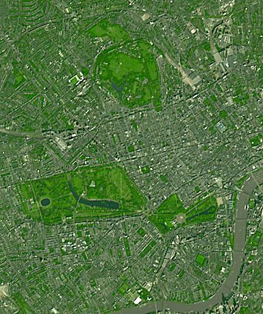
Three of London's many parks are found north of the Thames River. Regent's Park, at the top of the image, was originally a royal hunting ground; now it includes the London Zoo. Hyde Park, in the middle-left of the image, is the largest of the four royal parks, and was established by Henry VIII in 1536; it opened to the public in 1637. Buckingham Palace Garden, at the lower-right of the image, is the largest private garden in London. Today's garden was designed in 1825 under the reign of George IV. Summer garden parties see over 20,000 guests welcomed into the royal garden each summer. The image was acquired September 8, 2021. Covers an area of 5.8 by 6.9 km, and is located at 0.2 degrees west, 51.5 degrees north.
With its 14 spectral bands from the visible to the thermal infrared wavelength region and its high spatial resolution of about 50 to 300 feet (15 to 90 meters), ASTER images Earth to map and monitor the changing surface of our planet. ASTER is one of five Earth-observing instruments launched Dec. 18, 1999, on Terra. The instrument was built by Japan's Ministry of Economy, Trade and Industry. A joint U.S./Japan science team is responsible for validation and calibration of the instrument and data products.
The broad spectral coverage and high spectral resolution of ASTER provides scientists in numerous disciplines with critical information for surface mapping and monitoring of dynamic conditions and temporal change. Example applications are monitoring glacial advances and retreats; monitoring potentially active volcanoes; identifying crop stress; determining cloud morphology and physical properties; wetlands evaluation; thermal pollution monitoring; coral reef degradation; surface temperature mapping of soils and geology; and measuring surface heat balance.
The U.S. science team is located at NASA's Jet Propulsion Laboratory in Pasadena, Calif. The Terra mission is part of NASA's Science Mission Directorate, Washington.
More information about ASTER is available at http://asterweb.jpl.nasa.gov/.
 Planetary Data System


