PDS logoPlanetary Data System
PDS Information
Find a Node - Use these links to navigate to any of the 8 publicly accessible PDS Nodes.

This bar indicates that you are within the PDS enterprise which includes 6 science discipline nodes and 2 support nodes which are overseen by the Project Management Office at NASA's Goddard Space Flight Center (GSFC). Each node is led by an expert in the subject discipline, supported by an advisory group of other practitioners of that discipline, and subject to selection and approval under a regular NASA Research Announcement.
Click here to return to the Photojournal Home Page Click here to view a list of Photojournal Image Galleries Photojournal_inner_header
Latest Images  |  Spacecraft & Technology  |  Animations  |  Space Images App  |  Feedback  |  Photojournal Search  

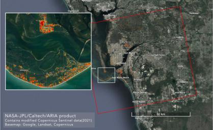
PIA25426: ARIA Maps Damage in Fort Myers From Hurricane Ian
 Target Name:  Earth
 Is a satellite of:  Sol (our sun)
 Mission:  ARIA
 Spacecraft:  Copernicus Sentinel-1
 Instrument:  SAR 
 Product Size:  4042 x 2475 pixels (w x h)
 Produced By:  European Space Agency (ESA)
 Full-Res TIFF:  PIA25426.tif (22.59 MB)
 Full-Res JPEG:  PIA25426.jpg (1.165 MB)

Click on the image above to download a moderately sized image in JPEG format (possibly reduced in size from original)

Original Caption Released with Image:

NASA scientists are using satellite data to assess the damage on Florida's Gulf Coast after Hurricane Ian, which made landfall in the state as a Category 4 storm on Sept. 28, 2022.

The Advanced Rapid Imaging and Analysis (ARIA) team at NASA's Jet Propulsion Laboratory and Caltech created this damage proxy map on Oct. 2, 2022, showing which parts of the Fort Myers area likely suffered storm damage. The map was derived from synthetic aperture radar (SAR) images acquired by the Copernicus Sentinel-1 satellites, which are operated by the European Space Agency (ESA).

Data from the satellites covered an area of approximately 2,491 square miles (6,452 square kilometers) outlined by the red rectangle. The color variation from pale yellow to red indicates greater drops in radar reflections compared with pre-storm imagery, an indication of possible damage. Preliminary validation was done by comparing the map with media reports and other images.

KMZ and GeoTIFF files are available to download at http://aria-share.jpl.nasa.gov.

Image Credit:
NASA/JPL-Caltech/ESA

Image Addition Date:
2022-10-06