Map Projected Browse Image
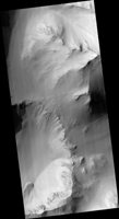
Click on image for larger versionIn geology, a slump forms a mass of loosely consolidated material or a rock layer moves a short distance down a slope. The movement is characterized by sliding along a concave-upward or planar surface.
Based on other HiRISE images, this particular slump occurred between 9 March 2020 and 17 February 2021, corresponding to the relatively warm spring and summer of the Southern Hemisphere. This is among the largest active slumps documented on Mars, about 700 meters (0.4 mile) long.
Causes of slumping on Earth include earthquake shocks, reduction of friction through wetting, freezing and thawing, undercutting (such as from a stream), and loading of a slope. Based on the geomorphology of this region and other active slumps seen on Mars, we suspect loading of the slope via smaller-scale activity like gullies, recurring slope lineae and windblown deposits may have contributed to the slumping. Perhaps a Marsquake triggered the movement.
Note to future Mars explorers: setting up camp at the base of this slope is not recommended.
The map is projected here at a scale of 50 centimeters (19.7 inches) per pixel. (The original image scale is 52.9 centimeters [20.8 inches] per pixel [with 2 x 2 binning]; objects on the order of 159 centimeters [62.6 inches] across are resolved.) North is up.
This is a stereo pair with ESP_069895_1640.
The University of Arizona, in Tucson, operates HiRISE, which was built by Ball Aerospace & Technologies Corp., in Boulder, Colorado. NASA's Jet Propulsion Laboratory, a division of Caltech in Pasadena, California, manages the Mars Reconnaissance Orbiter Project for NASA's Science Mission Directorate, Washington.

