PDS logoPlanetary Data System
PDS Information
Find a Node - Use these links to navigate to any of the 8 publicly accessible PDS Nodes.

This bar indicates that you are within the PDS enterprise which includes 6 science discipline nodes and 2 support nodes which are overseen by the Project Management Office at NASA's Goddard Space Flight Center (GSFC). Each node is led by an expert in the subject discipline, supported by an advisory group of other practitioners of that discipline, and subject to selection and approval under a regular NASA Research Announcement.
Click here to return to the Photojournal Home Page Click here to view a list of Photojournal Image Galleries Photojournal_inner_header
Latest Images  |  Spacecraft & Technology  |  Animations  |  Space Images App  |  Feedback  |  Photojournal Search  

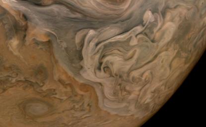
PIA24972: Clouds Stack Up in Jupiter's North Equatorial Belt
 Target Name:  Jupiter
 Is a satellite of:  Sol (our sun)
 Mission:  Juno
 Spacecraft:  Juno
 Instrument:  JunoCam
 Product Size:  3508 x 2160 pixels (w x h)
 Produced By:  Malin Space Science Systems
 Full-Res TIFF:  PIA24972.tif (21.27 MB)
 Full-Res JPEG:  PIA24972.jpg (515.3 kB)

Click on the image above to download a moderately sized image in JPEG format (possibly reduced in size from original)

Original Caption Released with Image:

The three-dimensional character of Jupiter's cloud decks is captured in this image of the planet's North Equatorial Belt. Orange storms peek out from under banks of dark gray clouds. Lighter tan and gray clouds cast narrow shadows on the dark gray cloud bank below. At the top are the "pop-up clouds," parcels of air pushed up to the altitude at which ammonia ice condenses to make small, bright clouds.

Jupiter appears to have a pastel hue to the naked eye through an Earth-based telescope. The color in this image from the JunoCam imager aboard NASA's Juno spacecraft has been "exaggerated," processed by citizen scientist Brian Swift to bring out subtle differences. The result is that the cloud layering is more obvious than in the original image.

This image was taken Oct. 16, 2021, at 10:07 a.m. PDT (1:07 p.m. EDT) as Juno performed its 37th close flyby of Jupiter. At the time the image was taken, the spacecraft was about 3,738 miles (6,016 kilometers) from the tops of the clouds of the planet at a latitude of 49.17 degrees.

JunoCam's raw images are available for the public to peruse and process into image products at https://missionjuno.swri.edu/junocam/processing. More information about NASA citizen science can be found at https://science.nasa.gov/citizenscience and https://www.nasa.gov/solve/opportunities/citizenscience.

More information about Juno is at https://www.nasa.gov/juno and https://missionjuno.swri.edu.

Image Credit:
Image data: NASA/JPL-Caltech/SwRI/MSSS
Image processing: Brian Swift CC BY

Image Addition Date:
2021-10-28