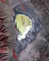
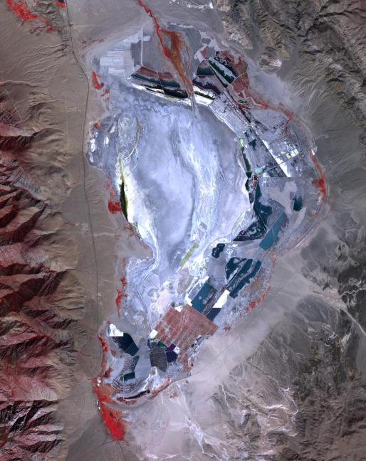
Owens Lake, CA, 1984
Click on the image for larger versionPrior to 1913, Owens Lake in eastern California had water up to a depth of 15 m, and covered an area of 280 km2. With the construction of the Los Angeles Aqueduct, all of the water from the Owens River was diverted to Los Angeles, and the lake dessicated, leading to dust storms that caused the worst air pollution in the state. Starting in 2002, various mitigation efforts were undertaken, including re-vegetation, flooding to create shallow ponds, and surface saturation to rehydrate the top layers. The Landsat image was acquired October 4, 1984 and the ASTER image on September 29, 2020. Both images cover an area of 25.6 by 32.3 km, and are located at 36.4 degrees north, 117.9 degrees west.
With its 14 spectral bands from the visible to the thermal infrared wavelength region and its high spatial resolution of about 50 to 300 feet (15 to 90 meters), ASTER images Earth to map and monitor the changing surface of our planet. ASTER is one of five Earth-observing instruments launched Dec. 18, 1999, on Terra. The instrument was built by Japan's Ministry of Economy, Trade and Industry. A joint U.S./Japan science team is responsible for validation and calibration of the instrument and data products.
The broad spectral coverage and high spectral resolution of ASTER provides scientists in numerous disciplines with critical information for surface mapping and monitoring of dynamic conditions and temporal change. Example applications are monitoring glacial advances and retreats; monitoring potentially active volcanoes; identifying crop stress; determining cloud morphology and physical properties; wetlands evaluation; thermal pollution monitoring; coral reef degradation; surface temperature mapping of soils and geology; and measuring surface heat balance.
The U.S. science team is located at NASA's Jet Propulsion Laboratory in Pasadena, Calif. The Terra mission is part of NASA's Science Mission Directorate, Washington.
More information about ASTER is available at http://asterweb.jpl.nasa.gov/.
 Planetary Data System


