PDS logoPlanetary Data System
PDS Information
Find a Node - Use these links to navigate to any of the 8 publicly accessible PDS Nodes.

This bar indicates that you are within the PDS enterprise which includes 6 science discipline nodes and 2 support nodes which are overseen by the Project Management Office at NASA's Goddard Space Flight Center (GSFC). Each node is led by an expert in the subject discipline, supported by an advisory group of other practitioners of that discipline, and subject to selection and approval under a regular NASA Research Announcement.
Click here to return to the Photojournal Home Page Click here to view a list of Photojournal Image Galleries Photojournal_inner_header
Latest Images  |  Spacecraft & Technology  |  Animations  |  Space Images App  |  Feedback  |  Photojournal Search  

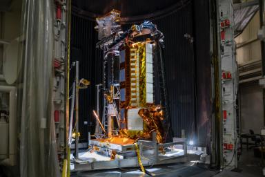
PIA24539: NISAR Testing
 Mission:  NISAR 
 Instrument:  L-Band Synthetic Aperture Radar 
S-Band Synthetic Aperture Radar 
 Product Size:  4128 x 2752 pixels (w x h)
 Produced By:  JPL
 Full-Res TIFF:  PIA24539.tif (30.04 MB)
 Full-Res JPEG:  PIA24539.jpg (1.467 MB)

Click on the image above to download a moderately sized image in JPEG format (possibly reduced in size from original)

Original Caption Released with Image:

Part of the NASA-ISRO Synthetic Aperture Radar (NISAR) satellite rests in a thermal vacuum chamber – meant to mimic the conditions found in space – at NASA's Jet Propulsion Laboratory in August 2020. Engineers tested the hardware in conditions similar to the ones NISAR will experience in space to see how it will hold up.

The SUV-size Earth satellite will track subtle changes in the planet's surface as small as 0.4 inches (a centimeter) over areas about the size of half a tennis court. NISAR will spot warning signs of imminent volcanic eruptions, help to monitor groundwater supplies, track the melt rate of ice sheets, and observe shifts in the distribution of vegetation around the world.

The mission is a joint effort between NASA and the Indian Space Research Organisation (ISRO) that will use two kinds of synthetic aperture radar (SAR) – operating on different wavelengths, an L-band and S-band – to measure changes in Earth's surface. JPL, which is managed for NASA by Caltech in Pasadena, leads the U.S. component of the project as well as providing the mission's L-band SAR. NASA is also providing the radar reflector antenna, the deployable boom, a high-rate communication subsystem for science data, GPS receivers, a solid-state recorder, and payload data subsystem. ISRO is providing the spacecraft bus, the S-band SAR, the launch vehicle, and associated launch services and satellite mission operations.

To learn more about the mission, visit: https://nisar.jpl.nasa.gov/

Image Credit:
NASA/JPL-Caltech

Image Addition Date:
2021-10-13