Map Projected Browse Image
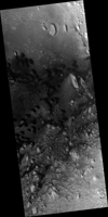
Click on image for larger versionSeveral craters in Arabia Terra are filled with layered rock, often exposed in rounded mounds. The bright layers are roughly the same thickness, giving a stair-step appearance.
The process that formed these sedimentary rocks is not yet well understood. They could have formed from sand or volcanic ash that was blown into the crater, or in water if the crater hosted a lake. One thing is certain, though: it wouldn't be hard to get your 10,000 daily steps when going on a hike in beautiful Arabia Terra!
The map is projected here at a scale of 25 centimeters (9.8 inches) per pixel. (The original image scale is 27.6 centimeters [10.9 inches] per pixel [with 1 x 1 binning]; objects on the order of 83 centimeters [32.7 inches] across are resolved.) North is up.
The University of Arizona, in Tucson, operates HiRISE, which was built by Ball Aerospace & Technologies Corp., in Boulder, Colorado. NASA's Jet Propulsion Laboratory, a division of Caltech in Pasadena, California, manages the Mars Reconnaissance Orbiter Project for NASA's Science Mission Directorate, Washington.

