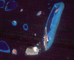
Figure 1, February 3, 1999
Click on the image for larger versionThe Maldives nation, in the Indian Ocean, faces an environmental threat from sea level rise, as 80% of its islands are less than 1 m above seal level. To counter this threat, the country is creating a new artificial island, Hulhumale. The capital city of Male, southwest of the new island and the airport, houses 130,000 people in 2.5 sq km. By 2019, more than 50,000 people had moved to Hulhumale, with plans to host 240,000 of the nation's people by the mid-2020s (BBC.com, December 31, 2020). The ASTER image was acquired December 22, 2018, the Landsat-5 image (Figure 1) was acquired February 3, 1999. The images cover an area of 9.2 by 11.3 km, and are located at 4.2 degrees north, 73.5 degrees east.
With its 14 spectral bands from the visible to the thermal infrared wavelength region and its high spatial resolution of about 50 to 300 feet (15 to 90 meters), ASTER images Earth to map and monitor the changing surface of our planet. ASTER is one of five Earth-observing instruments launched Dec. 18, 1999, on Terra. The instrument was built by Japan's Ministry of Economy, Trade and Industry. A joint U.S./Japan science team is responsible for validation and calibration of the instrument and data products.
The broad spectral coverage and high spectral resolution of ASTER provides scientists in numerous disciplines with critical information for surface mapping and monitoring of dynamic conditions and temporal change. Example applications are monitoring glacial advances and retreats; monitoring potentially active volcanoes; identifying crop stress; determining cloud morphology and physical properties; wetlands evaluation; thermal pollution monitoring; coral reef degradation; surface temperature mapping of soils and geology; and measuring surface heat balance.
The U.S. science team is located at NASA's Jet Propulsion Laboratory in Pasadena, Calif. The Terra mission is part of NASA's Science Mission Directorate, Washington.
More information about ASTER is available at http://asterweb.jpl.nasa.gov/.

