PDS logoPlanetary Data System
PDS Information
Find a Node - Use these links to navigate to any of the 8 publicly accessible PDS Nodes.

This bar indicates that you are within the PDS enterprise which includes 6 science discipline nodes and 2 support nodes which are overseen by the Project Management Office at NASA's Goddard Space Flight Center (GSFC). Each node is led by an expert in the subject discipline, supported by an advisory group of other practitioners of that discipline, and subject to selection and approval under a regular NASA Research Announcement.
Click here to return to the Photojournal Home Page Click here to view a list of Photojournal Image Galleries Photojournal_inner_header
Latest Images  |  Spacecraft & Technology  |  Animations  |  Space Images App  |  Feedback  |  Photojournal Search  

PIA24235: Tracking Clouds on Jupiter
 Target Name:  Jupiter
 Is a satellite of:  Sol (our sun)
 Mission:  Juno
 Spacecraft:  Juno
 Instrument:  JunoCam
 Product Size:  2779 x 1542 pixels (w x h)
 Produced By:  Malin Space Science Systems
 Full-Res TIFF:  PIA24235.tif (12.86 MB)
 Full-Res JPEG:  PIA24235.jpg (480.5 kB)

Click on the image above to download a moderately sized image in JPEG format (possibly reduced in size from original)

Original Caption Released with Image:

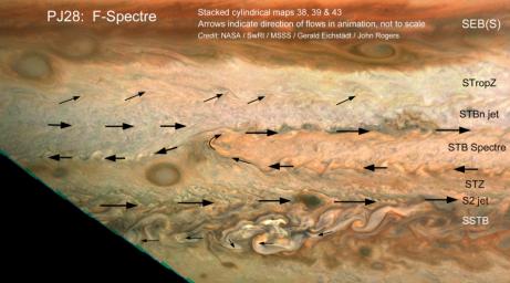
The motion of small clouds on Jupiter is used to determine wind direction (indicated with arrows) in this work by citizen scientists John Rogers and Gerald Eichstädt. Using multiple images to track the motion of clouds was enabled by the Juno spacecraft's slow departure from Jupiter's southern hemisphere on perijove pass 28, on July 25, 2020. Zonal winds are a well-known phenomenon on Jupiter, correlating with its familiar belts and zones. Within a latitudinal band there can be regional circulation, such as the South Temperate Belt (STB) Spectre shown in this image. The STB Spectre is cyclonic (winds rotating in clockwise direction), spread out in latitude but confined in longitude.

This work is representative of an ongoing and fruitful collaboration of amateur astronomers with the Juno project. John Rogers analyzed cloud movement in three JunoCam images processed by citizen scientist Gerald Eichstädt to identify winds. Latitudinal belts and zones ( labeled with the conventions used by the amateur astronomy community and professional observers), are: SEB(S): South Equatorial Belt (south); STropZ: South Tropical Zone; STBn jet: South Temperate Belt (north) jet; STZ: South Temperate Zone; and SSTB: South South Temperate Belt.

JunoCam's raw images are available for the public to peruse and process into image products at https://missionjuno.swri.edu/junocam/processing. More information about NASA citizen science can be found at https://science.nasa.gov/citizenscience and https://www.nasa.gov/solve/opportunities/citizenscience.

More information about Juno is at https://www.nasa.gov/juno and https://missionjuno.swri.edu.

Image Credit:
Image data: NASA/JPL-Caltech/SwRI/MSSS
Image processing: Gerald Eichstädt, John Rogers © CC BY

Image Addition Date:
2020-12-14