PDS logoPlanetary Data System
PDS Information
Find a Node - Use these links to navigate to any of the 8 publicly accessible PDS Nodes.

This bar indicates that you are within the PDS enterprise which includes 6 science discipline nodes and 2 support nodes which are overseen by the Project Management Office at NASA's Goddard Space Flight Center (GSFC). Each node is led by an expert in the subject discipline, supported by an advisory group of other practitioners of that discipline, and subject to selection and approval under a regular NASA Research Announcement.
Click here to return to the Photojournal Home Page Click here to view a list of Photojournal Image Galleries Photojournal_inner_header
Latest Images  |  Spacecraft & Technology  |  Animations  |  Space Images App  |  Feedback  |  Photojournal Search  

PIA24147: Cliffs in Ancient Ice
 Target Name:  Mars
 Is a satellite of:  Sol (our sun)
 Mission:  Mars Reconnaissance Orbiter (MRO)
 Spacecraft:  Mars Reconnaissance Orbiter (MRO)
 Instrument:  HiRISE
 Product Size:  2880 x 1800 pixels (w x h)
 Produced By:  University of Arizona/HiRISE-LPL
 Other  
Information: 
Other products from ESP_065881_1225
 Full-Res TIFF:  PIA24147.tif (15.56 MB)
 Full-Res JPEG:  PIA24147.jpg (1.107 MB)

Click on the image above to download a moderately sized image in JPEG format (possibly reduced in size from original)

Original Caption Released with Image:

Click here for larger image of PIA24147
Map Projected Browse Image
Click on image for larger version

Scientists have come to realize that, just below the surface, about one third of Mars is covered in ice. We study this ice to learn about Mars' ancient climate and astronauts' future water supplies.

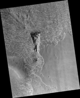
Sometimes we see the buried ice because cliffs form like the one in this image. On the brownish, dusty cliff wall, the faint light-blue-colored ice shows through. Some of these cliffs change before our eyes and boulders of ice can tumble downhill. We take repeat images of these scenes to check for changes like this.

The map is projected here at a scale of 25 centimeters (9.8 inches) per pixel. (The original image scale is 25.1 centimeters [9.9 inches] per pixel [with 1 x 1 binning]; objects on the order of 75 centimeters [29.5 inches] across are resolved.) North is up.

The University of Arizona, in Tucson, operates HiRISE, which was built by Ball Aerospace & Technologies Corp., in Boulder, Colorado. NASA's Jet Propulsion Laboratory, a division of Caltech in Pasadena, California, manages the Mars Reconnaissance Orbiter Project for NASA's Science Mission Directorate, Washington.

Image Credit:
NASA/JPL-Caltech/University of Arizona

Image Addition Date:
2020-10-12