PDS logoPlanetary Data System
PDS Information
Find a Node - Use these links to navigate to any of the 8 publicly accessible PDS Nodes.

This bar indicates that you are within the PDS enterprise which includes 6 science discipline nodes and 2 support nodes which are overseen by the Project Management Office at NASA's Goddard Space Flight Center (GSFC). Each node is led by an expert in the subject discipline, supported by an advisory group of other practitioners of that discipline, and subject to selection and approval under a regular NASA Research Announcement.
Click here to return to the Photojournal Home Page Click here to view a list of Photojournal Image Galleries Photojournal_inner_header
Latest Images  |  Spacecraft & Technology  |  Animations  |  Space Images App  |  Feedback  |  Photojournal Search  

PIA23894: Mars 2020's SHERLOC Instrument
 Mission:  Mars 2020 Project 
 Spacecraft:  Mars 2020 Rover
 Instrument:  Scanning Habitable Environments with Raman & Luminescence for Organics and Chemicals (SHERLOC) 
 Product Size:  11529 x 8648 pixels (w x h)
 Produced By:  JPL
 Full-Res TIFF:  PIA23894.tif (162.1 MB)
 Full-Res JPEG:  PIA23894.jpg (6.855 MB)

Click on the image above to download a moderately sized image in JPEG format (possibly reduced in size from original)

Original Caption Released with Image:

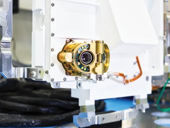
A close-up view of an engineering model of SHERLOC (Scanning Habitable Environments with Raman & Luminescence for Organics & Chemicals), one the instruments aboard NASA's Perseverance Mars rover. Located on the end of the rover's robotic arm, this instrument features an auto-focusing camera (pictured) that shoots black-and-white images used by SHERLOC's color camera, called WATSON (Wide Angle Topographic Sensor for Operations and eNgineering), to zero in on rock textures. SHERLOC also has a laser, which aims for the dead center of rock surfaces depicted in WATSON's images.

The laser uses a technique called Raman spectroscopy to detect minerals in microscopic rock features; that data is then superimposed on WATSON's images. These mineral maps help scientists determine which rock samples Perseverance should drill so that they can be sealed in metal tubes and left on the Martian surface for a future mission to return to Earth.

For more information about the mission, go to https://mars.nasa.gov/mars2020/.

Image Credit:
NASA/JPL-Caltech

Image Addition Date:
2020-05-26