Map Projected Browse Image
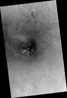
Click on image for larger versionThis image covers the inside of an impact crater on the northern plains of Mars. It was intended to provide a baseline image of sand dunes on the crater floor, which could be monitored for potential motion in future pictures.
Much more than sand is visible. The dark, undulating dunes sit atop a colorful surface of exposed bedrock. Based on the crater's diameter of roughly 25 kilometers, these rocks may have been previously buried over a mile beneath the surface. The varying colors likely reflect diverse mineral compositions. (The CRISM instrument, also on MRO, has detected different minerals in the neighboring larger Micoud Crater, whose rim lies about 50 kilometers east-southeast of this image.)
Excavated by impact, the colorful rocks here remain visible in part thanks to the winds that shape the overlying sand dunes, which help to sweep the crater's center clear of surface dust.
The map is projected here at a scale of 25 centimeters (9.8 inches) per pixel. (The original image scale is 30.6 centimeters [12.0 inches] per pixel [with 1 x 1 binning]; objects on the order of 92 centimeters [36.2 inches] across are resolved.) North is up.
The University of Arizona, in Tucson, operates HiRISE, which was built by Ball Aerospace & Technologies Corp., in Boulder, Colorado. NASA's Jet Propulsion Laboratory, a division of Caltech in Pasadena, California, manages the Mars Reconnaissance Orbiter Project for NASA's Science Mission Directorate, Washington.

