PDS logoPlanetary Data System
PDS Information
Find a Node - Use these links to navigate to any of the 8 publicly accessible PDS Nodes.

This bar indicates that you are within the PDS enterprise which includes 6 science discipline nodes and 2 support nodes which are overseen by the Project Management Office at NASA's Goddard Space Flight Center (GSFC). Each node is led by an expert in the subject discipline, supported by an advisory group of other practitioners of that discipline, and subject to selection and approval under a regular NASA Research Announcement.
Click here to return to the Photojournal Home Page Click here to view a list of Photojournal Image Galleries Photojournal_inner_header
Latest Images  |  Spacecraft & Technology  |  Animations  |  Space Images App  |  Feedback  |  Photojournal Search  

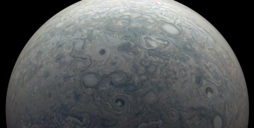
PIA23810: Jupiter's Visible and Invisible Winds
 Target Name:  Jupiter
 Is a satellite of:  Sol (our sun)
 Mission:  Juno
 Spacecraft:  Juno
 Instrument:  JunoCam
 Product Size:  3327 x 1677 pixels (w x h)
 Produced By:  Malin Space Science Systems
 Full-Res TIFF:  PIA23810.tif (10.44 MB)
 Full-Res JPEG:  PIA23810.jpg (388.8 kB)

Click on the image above to download a moderately sized image in JPEG format (possibly reduced in size from original)

Original Caption Released with Image:

This image from NASA's Juno mission captures the northern hemisphere of Jupiter around the region known as Jet N7. The planet's strong winds create the many swirling storms visible near the top of its atmosphere. Data from Juno helped scientists discover another, less visible effect of those winds: Jupiter's powerful magnetic field changes over time. The winds extend more than 1800 miles (3000 kilometers) deep, where the material lower in Jupiter's atmosphere is highly conductive, electrically. Scientists determined that the wind shears this conductive material apart and carries it around the planet, which changes the shape of the magnetic field.

Citizen scientist Kevin M. Gill created this false-color image using data from the JunoCam camera. The original image was taken on February 21, 2021 as the Juno spacecraft performed its 32nd close flyby of Jupiter. At the time, the spacecraft was about 10,200 miles (16,400 kilometers) from the tops of the clouds at a latitude of about 66 degrees north.

JunoCam's raw images are available for the public to peruse and process into image products at https://missionjuno.swri.edu/junocam/processing. More information about NASA citizen science can be found at https://science.nasa.gov/citizenscience and https://www.nasa.gov/solve/opportunities/citizenscience.

More information about Juno is at http://www.nasa.gov/juno and http://missionjuno.swri.edu. For more about this finding and other science results, see https://www.missionjuno.swri.edu/science-findings.

Image Credit:
Image data: NASA/JPL-Caltech/SwRI/MSSS
Image processing by Kevin M. Gill © CC BY

Image Addition Date:
2021-03-25