Map Projected Browse Image
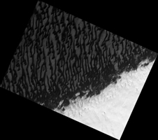
Click on image for larger versionThis image covers the boundary between north polar ice and nearby polar sand dunes. The color data clearly distinguishes between the bright ice, dark sand, and reddish dust.
An animation compares an exact same area to how it appeared in March 2009 at the same Martian time of year. The dark sand appears to be on the move, covering much of this area that was formerly bright ice or dust-covered ice. However, this may also show year-on-year variability of seasonal processes. In other words, this area may have looked similar in 2009 a month or so after the HiRISE image was acquired. The seasonal defrosting patterns vary from year to year, perhaps depending on dust storm activity.
The map is projected here at a scale of 25 centimeters (9.8 inches) per pixel. (The original image scale is 31.9 centimeters [12.6 inches] per pixel [with 1 x 1 binning]; objects on the order of 96 centimeters [37.8 inches] across are resolved.) North is up.
The University of Arizona, in Tucson, operates HiRISE, which was built by Ball Aerospace & Technologies Corp., in Boulder, Colorado. NASA's Jet Propulsion Laboratory, a division of Caltech in Pasadena, California, manages the Mars Reconnaissance Orbiter Project for NASA's Science Mission Directorate, Washington.

