Map Projected Browse Image
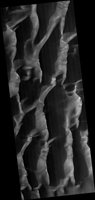
Click on image for larger versionHiRISE has been monitoring this dune field since 2008, and it changes every year from gully erosion in the winter and blowing sand in the summer.
This cutout shows an especially large gully. The bright white materials are seasonal frost, persisting on shaded slopes.
The map is projected here at a scale of 50 centimeters (19.7 inches) per pixel. (The original image scale is 50.9 centimeters [20.0 inches] per pixel [with 2 x 2 binning]; objects on the order of 153 centimeters [60.2 inches] across are resolved.) North is up.
The University of Arizona, in Tucson, operates HiRISE, which was built by Ball Aerospace & Technologies Corp., in Boulder, Colorado. NASA's Jet Propulsion Laboratory, a division of Caltech in Pasadena, California, manages the Mars Reconnaissance Orbiter Project for NASA's Science Mission Directorate, Washington.

