Map Projected Browse Image
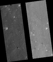
Click on image for larger versionThis HiRISE image was taken to sample terrain north of Elysium Planitia and Athabasca Valles. Because HiRISE can only image a small fraction of Mars, most images are targeted on specially selected features of interest. However, we also sample other locations, both to understand the normal terrain and look for things that might not have been obvious enough in other data for anyone to mark out a target.
This image caught something interesting. Most of the surface is smooth regolith peppered with small craters. However, some of the craters are notably dark compared with everything else in the image.
Zooming in to full resolution shows the reason: the dark craters have small ripples and are dark blue in enhanced color, characteristics usually associated with active sand kicking off its dust cover. Why the sand is moving in these particular craters but not others is not certain but could relate to induration (hardening) of the sand, or the age or topography of the craters.
The map is projected here at a scale of 50 centimeters (19.7 inches) per pixel. (The original image scale is 61.7 centimeters [24.3 inches] per pixel [with 2 x 2 binning]; objects on the order of 185 centimeters [72.8 inches] across are resolved.) North is up.
The University of Arizona, in Tucson, operates HiRISE, which was built by Ball Aerospace & Technologies Corp., in Boulder, Colorado. NASA's Jet Propulsion Laboratory, a division of Caltech in Pasadena, California, manages the Mars Reconnaissance Orbiter Project for NASA's Science Mission Directorate, Washington.

