PDS logoPlanetary Data System
PDS Information
Find a Node - Use these links to navigate to any of the 8 publicly accessible PDS Nodes.

This bar indicates that you are within the PDS enterprise which includes 6 science discipline nodes and 2 support nodes which are overseen by the Project Management Office at NASA's Goddard Space Flight Center (GSFC). Each node is led by an expert in the subject discipline, supported by an advisory group of other practitioners of that discipline, and subject to selection and approval under a regular NASA Research Announcement.
Click here to return to the Photojournal Home Page Click here to view a list of Photojournal Image Galleries Photojournal_inner_header
Latest Images  |  Spacecraft & Technology  |  Animations  |  Space Images App  |  Feedback  |  Photojournal Search  

PIA23077: The Slow Charm of Brain Terrain
 Target Name:  Mars
 Is a satellite of:  Sol (our sun)
 Mission:  Mars Reconnaissance Orbiter (MRO)
 Spacecraft:  Mars Reconnaissance Orbiter (MRO)
 Instrument:  HiRISE
 Product Size:  2880 x 1800 pixels (w x h)
 Produced By:  University of Arizona/HiRISE-LPL
 Other  
Information: 
Other products from ESP_058008_2225
 Full-Res TIFF:  PIA23077.tif (15.56 MB)
 Full-Res JPEG:  PIA23077.jpg (1.528 MB)

Click on the image above to download a moderately sized image in JPEG format (possibly reduced in size from original)

Original Caption Released with Image:

Click here for larger image of PIA23077
Map Projected Browse Image
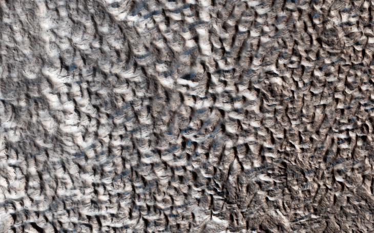
Click on image for larger version

You are staring at one of the unsolved mysteries on Mars. This surface texture of interconnected ridges and troughs, referred to as "brain terrain" is found throughout the mid-latitude regions of Mars. (This image is in Protonilus Mensae.)

This bizarrely textured terrain may be directly related to the water-ice that lies beneath the surface. One hypothesis is that when the buried water-ice sublimates (changes from a solid to a gas), it forms the troughs in the ice. The formation of these features might be an active process that is slowly occurring since HiRISE has yet to detect significant changes in these terrains.

The map is projected here at a scale of 25 centimeters (9.8 inches) per pixel. [The original image scale is 29.6 centimeters (11.7 inches) per pixel (with 1 x 1 binning) to 59.3 centimeters (23.3 inches) per pixel (with 2 x 2 binning).] North is up.

The University of Arizona, Tucson, operates HiRISE, which was built by Ball Aerospace & Technologies Corp., Boulder, Colorado. NASA's Jet Propulsion Laboratory, a division of Caltech in Pasadena, California, manages the Mars Reconnaissance Orbiter Project for NASA's Science Mission Directorate, Washington.

Image Credit:
NASA/JPL-Caltech/University of Arizona

Image Addition Date:
2019-03-04