PDS logoPlanetary Data System
PDS Information
Find a Node - Use these links to navigate to any of the 8 publicly accessible PDS Nodes.

This bar indicates that you are within the PDS enterprise which includes 6 science discipline nodes and 2 support nodes which are overseen by the Project Management Office at NASA's Goddard Space Flight Center (GSFC). Each node is led by an expert in the subject discipline, supported by an advisory group of other practitioners of that discipline, and subject to selection and approval under a regular NASA Research Announcement.
Click here to return to the Photojournal Home Page Click here to view a list of Photojournal Image Galleries Photojournal_inner_header
Latest Images  |  Spacecraft & Technology  |  Animations  |  Space Images App  |  Feedback  |  Photojournal Search  

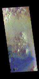
PIA23054: Crater Dunes - False Color
 Target Name:  Mars
 Is a satellite of:  Sol (our sun)
 Mission:  2001 Mars Odyssey
 Spacecraft:  2001 Mars Odyssey
 Instrument:  THEMIS
 Product Size:  703 x 1432 pixels (w x h)
 Produced By:  Arizona State University
 Full-Res TIFF:  PIA23054.tif (1.971 MB)
 Full-Res JPEG:  PIA23054.jpg (75.32 kB)

Click on the image above to download a moderately sized image in JPEG format (possibly reduced in size from original)

Original Caption Released with Image:

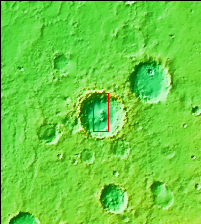
Context image for PIA23054
Context image

This VIS image shows the floor of an unnamed crater in Arabia Terra. The peaks in the center of the crater floor were formed by the rebound of melted rock at the time of the impact. There are individual sand dunes in the southern half of the crater. The dark blue tone in this filter combination indicates that the dunes are made of basaltic sand.

The THEMIS VIS camera contains 5 filters. The data from different filters can be combined in multiple ways to create a false color image. These false color images may reveal subtle variations of the surface not easily identified in a single band image.

Orbit Number: 60976 Latitude: 10.0004 Longitude: 8.21209 Instrument: VIS Captured: 2015-09-12 12:29

Please see the THEMIS Data Citation Note for details on crediting THEMIS images.

NASA's Jet Propulsion Laboratory manages the 2001 Mars Odyssey mission for NASA's Science Mission Directorate, Washington, D.C. The Thermal Emission Imaging System (THEMIS) was developed by Arizona State University, Tempe, in collaboration with Raytheon Santa Barbara Remote Sensing. The THEMIS investigation is led by Dr. Philip Christensen at Arizona State University. Lockheed Martin Astronautics, Denver, is the prime contractor for the Odyssey project, and developed and built the orbiter. Mission operations are conducted jointly from Lockheed Martin and from JPL, a division of the California Institute of Technology in Pasadena.

Image Credit:
NASA/JPL-Caltech/ASU

Image Addition Date:
2019-02-27