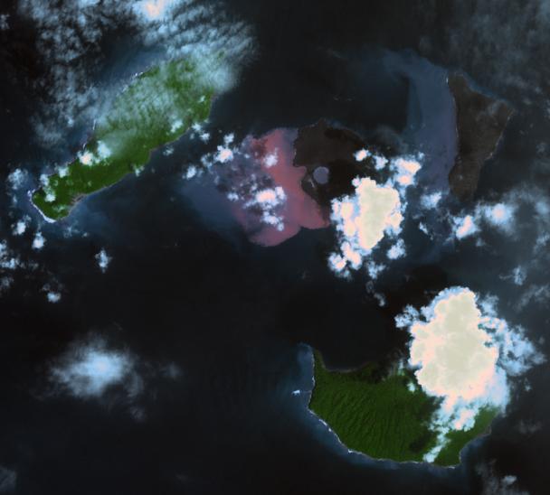
On Dec. 22, 2018, Indonesia's Anak Krakatau volcano erupted and partially collapsed. NASA's Advanced Spaceborne Thermal Emission and Reflection (ASTER) instrument imaged the volcano on Jan. 13 -- several weeks after the eruption.
This image shows that the crater area has closed to become a lake and the forest on the island has been destroyed by ash falls. The reddish area in the water southwest of the island is likely due to either iron-rich ash in the water or the interaction of seawater with underwater volcanic eruption products. The image covers an area of 7.5 by 8.4 miles (12.2 by 13.5 kilometers), and is located at 6.1 degrees south, 105.4 degrees east.
The tsunami that followed the eruption killed more than 400 people in western Indonesia.
With its 14 spectral bands from the visible to the thermal infrared wavelength region and its high spatial resolution of about 50 to 300 feet (15 to 90 meters), ASTER images Earth to map and monitor the changing surface of our planet. ASTER is one of five Earth-observing instruments launched Dec. 18, 1999, on Terra. The instrument was built by Japan's Ministry of Economy, Trade and Industry. A joint U.S./Japan science team is responsible for validation and calibration of the instrument and data products.
The broad spectral coverage and high spectral resolution of ASTER provides scientists in numerous disciplines with critical information for surface mapping and monitoring of dynamic conditions and temporal change. Example applications are monitoring glacial advances and retreats; monitoring potentially active volcanoes; identifying crop stress; determining cloud morphology and physical properties; wetlands evaluation; thermal pollution monitoring; coral reef degradation; surface temperature mapping of soils and geology; and measuring surface heat balance.
The U.S. science team is located at NASA's Jet Propulsion Laboratory in Pasadena, California. The Terra mission is part of NASA's Science Mission Directorate, Washington.
More information about ASTER is available at http://asterweb.jpl.nasa.gov/.
 Planetary Data System


