PDS logoPlanetary Data System
PDS Information
Find a Node - Use these links to navigate to any of the 8 publicly accessible PDS Nodes.

This bar indicates that you are within the PDS enterprise which includes 6 science discipline nodes and 2 support nodes which are overseen by the Project Management Office at NASA's Goddard Space Flight Center (GSFC). Each node is led by an expert in the subject discipline, supported by an advisory group of other practitioners of that discipline, and subject to selection and approval under a regular NASA Research Announcement.
Click here to return to the Photojournal Home Page Click here to view a list of Photojournal Image Galleries Photojournal_inner_header
Latest Images  |  Spacecraft & Technology  |  Animations  |  Space Images App  |  Feedback  |  Photojournal Search  

PIA22785: Summit Dunes and Their Sand Sources
 Target Name:  Mars
 Is a satellite of:  Sol (our sun)
 Mission:  Mars Reconnaissance Orbiter (MRO)
 Spacecraft:  Mars Reconnaissance Orbiter (MRO)
 Instrument:  HiRISE
 Product Size:  2880 x 1800 pixels (w x h)
 Produced By:  University of Arizona/HiRISE-LPL
 Other  
Information: 
Other products from ESP_054082_1765
 Full-Res TIFF:  PIA22785.tif (15.56 MB)
 Full-Res JPEG:  PIA22785.jpg (929.3 kB)

Click on the image above to download a moderately sized image in JPEG format (possibly reduced in size from original)

Original Caption Released with Image:

Click here for larger image of PIA22785
Map Projected Browse Image
Click on image for larger version

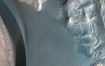
The ultimate origin of the sediment that forms Martian dunes has long been debated. While sand dunes on Earth are primarily sourced by quartz-bearing components of granitic continental crust, it's often suggested that sand on Mars derives from eroded volcanic flows or sedimentary deposits, but exact sources are often vague.

This image reveals a unique situation where this small dune field occurs along the summit of the large 1-mile-tall mound near the center of Juventae Chasma. The layered mound slopes are far too steep for dunes to climb, and bedform sand is unlikely to come from purely airborne material. Instead, the mound's summit displays several dark-toned, mantled deposits that are adjacent to the dunes and appear to be eroding into fans of sandy material.

Along with local HiRISE images, spectral data from other instruments on MRO have confirmed such units are likely to be the sand source for these mound summit dunes and reveal how landscape evolution on Mars might occur.

The map is projected here at a scale of 25 centimeters (9.8 inches) per pixel. [The original image scale is 27.8 centimeters (10.9 inches) per pixel (with 1 x 1 binning); objects on the order of 83 centimeters (32.7 inches) across are resolved.] North is up.

The University of Arizona, Tucson, operates HiRISE, which was built by Ball Aerospace & Technologies Corp., Boulder, Colorado. NASA's Jet Propulsion Laboratory, a division of Caltech in Pasadena, California, manages the Mars Reconnaissance Orbiter Project for NASA's Science Mission Directorate, Washington.

Image Credit:
NASA/JPL-Caltech/Univ. of Arizona

Image Addition Date:
2018-10-01