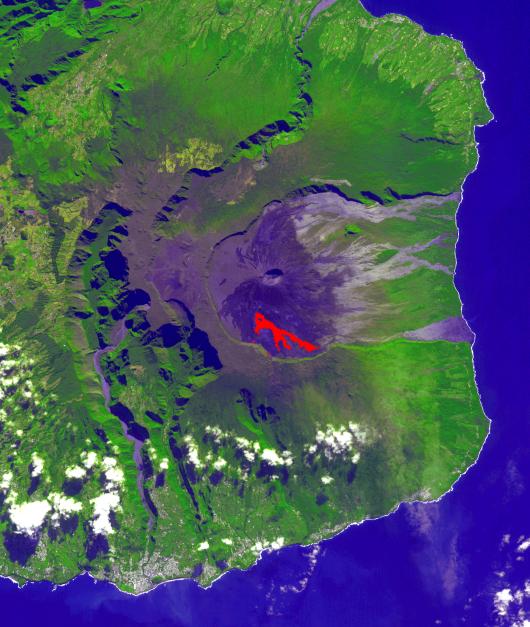
In July, 2018 an eruption began from Piton de la Fournaise volcano on Reunion Island in the western Indian Ocean. Activity continued through November, when these ASTER data were acquired. More than 150 eruptions have occurred since the 17th century. The active flow, derived from the thermal infrared band, is shown in red. The background is a pre-eruption image. The background image was acquired July 16, 2018, and the thermal image on November 1, 2018. The images cover an area of 18 miles by 21 miles (28.9 by 34.2 kilometers), and in the area of 21.3 degrees south, 55.8 degrees east.
With its 14 spectral bands from the visible to the thermal infrared wavelength region and its high spatial resolution of about 50 to 300 feet (15 to 90 meters), ASTER images Earth to map and monitor the changing surface of our planet. ASTER is one of five Earth-observing instruments launched Dec. 18, 1999, on Terra. The instrument was built by Japan's Ministry of Economy, Trade and Industry. A joint U.S./Japan science team is responsible for validation and calibration of the instrument and data products.
The broad spectral coverage and high spectral resolution of ASTER provides scientists in numerous disciplines with critical information for surface mapping and monitoring of dynamic conditions and temporal change. Example applications are monitoring glacial advances and retreats; monitoring potentially active volcanoes; identifying crop stress; determining cloud morphology and physical properties; wetlands evaluation; thermal pollution monitoring; coral reef degradation; surface temperature mapping of soils and geology; and measuring surface heat balance.
The U.S. science team is located at NASA's Jet Propulsion Laboratory in Pasadena, California. The Terra mission is part of NASA's Science Mission Directorate, Washington.
More information about ASTER is available at http://asterweb.jpl.nasa.gov/.