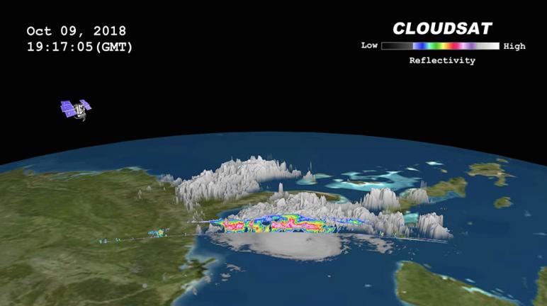
CloudSat passed over Hurricane Michael on October 9, 2018 at 3:15 p.m. EDT (19:15 UTC) as the storm was intensifying and moving northwest toward the Florida panhandle in the Gulf of Mexico. At that time, Hurricane Michael contained estimated sustained winds of 105 knots (120 mph) making the storm a Category 3 (major hurricane).
CloudSat passed over the eastern portion of the storm through an area of moderate to heavy precipitation. Large amounts of liquid and ice water (denoted by the red and pink colors) are detected beneath the cold cloud tops. The lack of signal (attenuation) beneath the freezing layer (around 5 km in height) can be seen in the heavier areas of precipitation as CloudSat's cloud profiling radar (CPR) signal dampens when particles are larger than 3 mm in size. Cloud top height averages between 13-15 km with an overshooting cloud top in the northern part of the overpass. Lower values of reflectivity (areas of green and blue) denote smaller ice and water particle sizes typically located at top of the system (in the anvil area).
The image combines GOES-16 imagery and the CloudSat overpass.
CloudSat is a satellite mission designed to measure the vertical structure of clouds from space. The radar data produces detailed images of cloud structures which will contribute to a better understanding of clouds and climate. Quicklook Images can viewed at the CloudSat Data Processing Center.