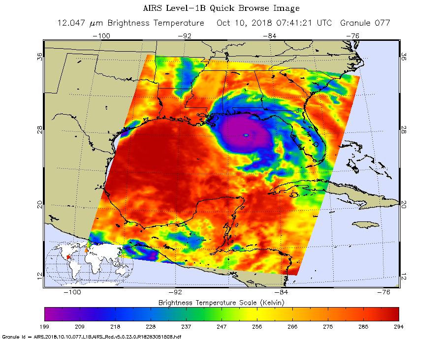
This image from the Atmospheric Infrared Sounder (AIRS) shows the temperature of clouds or the surface in and around Hurricane Michael as it approaches northwestern Florida around 3 AM local time on Tuesday, October 10, 2018. The storm shows all the hallmarks of a powerful, mature hurricane. The large purple area indicates very cold clouds at about -90° F (-68° C) carried high into the atmosphere by deep thunderstorms. These storm clouds are associated with very heavy rainfall. At the center of the cold clouds is the distinct, much warmer eye of the hurricane seen in green. The extensive areas of red away from the storm indicate temperatures of around 60° F (15° C), typical of the surface of the Earth at night. These red areas are mostly cloud-free, with the clear air caused by air motion outward from the cold clouds near the storm center then downward in the surrounding areas. Michael has developed quickly into a dangerous Category 4 storm, with sustained wind of 150 miles per hour. It is currently coming ashore on the Florida Panhandle as the strongest hurricane in that region in recorded history.
AIRS, in conjunction with the Advanced Microwave Sounding Unit, AMSU, senses emitted infrared and microwave radiation from Earth to provide a three-dimensional look at Earth's weather and climate. Working in tandem, the two instruments make simultaneous observations down to Earth's surface, even in the presence of heavy clouds. With more than 2,000 channels sensing different regions of the atmosphere, the system creates a global, three-dimensional map of atmospheric temperature and humidity, cloud amounts and heights, greenhouse gas concentrations, and many other atmospheric phenomena. Launched into Earth orbit in 2002, the AIRS and AMSU instruments fly onboard NASA's Aqua spacecraft and are managed by NASA's Jet Propulsion Laboratory in Pasadena, California, under contract to NASA. JPL is a division of the California Institute of Technology in Pasadena.
More information about AIRS can be found at https://airs.jpl.nasa.gov.
