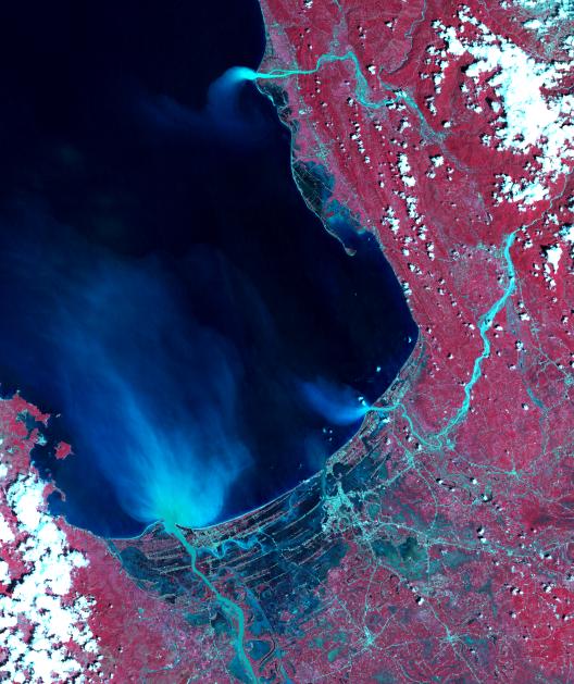
Super typhoon Mangkhut slammed into the northern Philippines on September 15 with wind speeds equivalent to a category 5 hurricane. South of where the eye made landfall, the storm's effects could be seen clearly five days later. The ASTER image of Dagupan and the Lingayen Gulf shows flooded and water-saturated areas in dark blue. Sediment-laden waters from swollen rivers enter the ocean and appear as blue-green plumes. The image was acquired September 22, 2018, covers an area of 51.4 by 61.2 kilometers, and is located at 16.2 degrees north, 120.3 degrees east.
With its 14 spectral bands from the visible to the thermal infrared wavelength region and its high spatial resolution of about 50 to 300 feet (15 to 90 meters), ASTER images Earth to map and monitor the changing surface of our planet. ASTER is one of five Earth-observing instruments launched Dec. 18, 1999, on Terra. The instrument was built by Japan's Ministry of Economy, Trade and Industry. A joint U.S./Japan science team is responsible for validation and calibration of the instrument and data products.
The broad spectral coverage and high spectral resolution of ASTER provides scientists in numerous disciplines with critical information for surface mapping and monitoring of dynamic conditions and temporal change. Example applications are monitoring glacial advances and retreats; monitoring potentially active volcanoes; identifying crop stress; determining cloud morphology and physical properties; wetlands evaluation; thermal pollution monitoring; coral reef degradation; surface temperature mapping of soils and geology; and measuring surface heat balance.
The U.S. science team is located at NASA's Jet Propulsion Laboratory in Pasadena, California. The Terra mission is part of NASA's Science Mission Directorate, Washington.
More information about ASTER is available at http://asterweb.jpl.nasa.gov/.