PDS logoPlanetary Data System
PDS Information
Find a Node - Use these links to navigate to any of the 8 publicly accessible PDS Nodes.

This bar indicates that you are within the PDS enterprise which includes 6 science discipline nodes and 2 support nodes which are overseen by the Project Management Office at NASA's Goddard Space Flight Center (GSFC). Each node is led by an expert in the subject discipline, supported by an advisory group of other practitioners of that discipline, and subject to selection and approval under a regular NASA Research Announcement.
Click here to return to the Photojournal Home Page Click here to view a list of Photojournal Image Galleries Photojournal_inner_header
Latest Images  |  Spacecraft & Technology  |  Animations  |  Space Images App  |  Feedback  |  Photojournal Search  

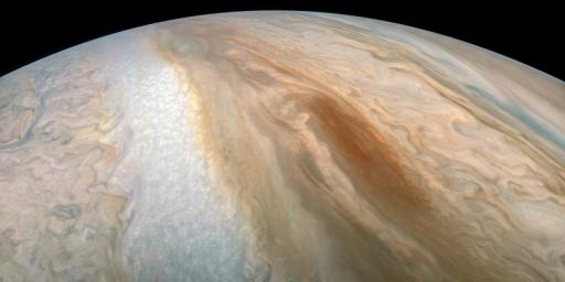
PIA22688: Juno Captures Elusive 'Brown Barge'
 Target Name:  Jupiter
 Is a satellite of:  Sol (our sun)
 Mission:  Juno
 Spacecraft:  Juno
 Instrument:  JunoCam
 Product Size:  3600 x 1800 pixels (w x h)
 Produced By:  SwRI
 Full-Res TIFF:  PIA22688.tif (15.84 MB)
 Full-Res JPEG:  PIA22688.jpg (623.6 kB)

Click on the image above to download a moderately sized image in JPEG format (possibly reduced in size from original)

Original Caption Released with Image:

A long, brown oval known as a "brown barge" in Jupiter's South Equatorial Belt is captured in this color-enhanced image from NASA's Juno spacecraft.

Brown barges are cyclonic regions that usually lie within Jupiter's dark North Equatorial Belt, although they are sometimes found in the similarly dark South Equatorial Belt as well. They can often be difficult to detect visually because their color blends in with the dark surroundings. At other times, as with this image, the dark belt material recedes, creating a lighter-colored background against which the brown barge is more conspicuous. Brown barges usually dissipate after the entire cloud belt undergoes an upheaval and reorganizes itself. Juno is giving us the first glimpses of the detailed structure within such a barge.

This image was taken at 6:26 p.m. PDT on Sept. 6, 2018 (9:26 p.m. EDT) as the spacecraft performed its 15th close flyby of Jupiter. At the time, Juno was 7,425 miles (11,950 kilometers) from the planet's cloud tops, above a southern latitude of approximately 22 degrees.

Citizen scientist Kevin M. Gill created this image using data from the spacecraft's JunoCam imager. The image has been rotated 90 degrees to the right from the original image.

JunoCam's raw images are available at www.missionjuno.swri.edu/junocam for the public to peruse and process into image products.

More information about Juno is online at http://www.nasa.gov/juno and http://missionjuno.swri.edu.

NASA's Jet Propulsion Laboratory manages the Juno mission for the principal investigator, Scott Bolton, of Southwest Research Institute in San Antonio. Juno is part of NASA's New Frontiers Program, which is managed at NASA's Marshall Space Flight Center in Huntsville, Alabama, for NASA's Science Mission Directorate. Lockheed Martin Space Systems, Denver, built the spacecraft. Caltech in Pasadena, California, manages JPL for NASA.

Image Credit:
Enhanced image by Kevin M. Gill (CC-BY) based on images provided courtesy of NASA/JPL-Caltech/SwRI/MSSS.
Media Usage Guidelines

Image Addition Date:
2018-09-13