PDS logoPlanetary Data System
PDS Information
Find a Node - Use these links to navigate to any of the 8 publicly accessible PDS Nodes.

This bar indicates that you are within the PDS enterprise which includes 6 science discipline nodes and 2 support nodes which are overseen by the Project Management Office at NASA's Goddard Space Flight Center (GSFC). Each node is led by an expert in the subject discipline, supported by an advisory group of other practitioners of that discipline, and subject to selection and approval under a regular NASA Research Announcement.
Click here to return to the Photojournal Home Page Click here to view a list of Photojournal Image Galleries Photojournal_inner_header
Latest Images  |  Spacecraft & Technology  |  Animations  |  Space Images App  |  Feedback  |  Photojournal Search  

PIA22587: Jamming with the 'Spiders' from Mars
 Target Name:  Mars
 Is a satellite of:  Sol (our sun)
 Mission:  Mars Reconnaissance Orbiter (MRO)
 Spacecraft:  Mars Reconnaissance Orbiter (MRO)
 Instrument:  HiRISE
 Product Size:  2880 x 1800 pixels (w x h)
 Produced By:  University of Arizona/HiRISE-LPL
 Other  
Information: 
Other products from ESP_055283_0985
 Full-Res TIFF:  PIA22587.tif (15.56 MB)
 Full-Res JPEG:  PIA22587.jpg (1.352 MB)

Click on the image above to download a moderately sized image in JPEG format (possibly reduced in size from original)

Original Caption Released with Image:

Click here for larger image of PIA22587
Map Projected Browse Image
Click on image for larger version

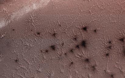
This image from NASA's Mars Reconnaissance Orbiter, acquired May 13, 2018 during winter at the South Pole of Mars, shows a carbon dioxide ice cap covering the region and as the sun returns in the spring, "spiders" begin to emerge from the landscape.

But these aren't actual spiders. Called "araneiform terrain," describes the spider-like radiating mounds that form when carbon dioxide ice below the surface heats up and releases. This is an active seasonal process not seen on Earth. Like dry ice on Earth, the carbon dioxide ice on Mars sublimates as it warms (changes from solid to gas) and the gas becomes trapped below the surface.

Over time the trapped carbon dioxide gas builds in pressure and is eventually strong enough to break through the ice as a jet that erupts dust. The gas is released into the atmosphere and darker dust may be deposited around the vent or transported by winds to produce streaks. The loss of the sublimated carbon dioxide leaves behind these spider-like features etched into the surface.

The map is projected here at a scale of 50 centimeters (19.7 inches) per pixel. [The original image scale is 49.4 centimeters (19.4 inches) per pixel (with 2 x 2 binning); objects on the order of 148 centimeters (58.2 inches) across are resolved.] North is up.

The University of Arizona, Tucson, operates HiRISE, which was built by Ball Aerospace & Technologies Corp., Boulder, Colorado. NASA's Jet Propulsion Laboratory, a division of Caltech in Pasadena, California, manages the Mars Reconnaissance Orbiter Project for NASA's Science Mission Directorate, Washington.

Image Credit:
NASA/JPL-Caltech/Univ. of Arizona

Image Addition Date:
2018-07-09