PIA22241: Crater Tadpoles
 Target Name:  Mars
 Is a satellite of:  Sol (our sun)
 Mission:  Mars Reconnaissance Orbiter (MRO)
 Spacecraft:  Mars Reconnaissance Orbiter (MRO)
 Instrument:  HiRISE
 Product Size:  899 x 476 pixels (w x h)
 Produced By:  University of Arizona/HiRISE-LPL
 Other  
Information: 
Other products from ESP_053222_2150
 Full-Res TIFF:  PIA22241.tif (428.6 kB)
 Full-Res JPEG:  PIA22241.jpg (147.2 kB)

Click on the image above to download a moderately sized image in JPEG format (possibly reduced in size from original)

Original Caption Released with Image:

Click here for larger version of PIA22241
Map Projected Browse Image
Click on the image for larger version

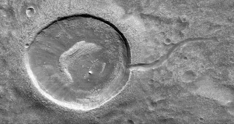
This image from NASA's Mars Reconnaissance Orbiter (MRO) shows an impact crater looking amusingly like a tadpole because of the valley that was carved by water that used to fill it.

It is often difficult to differentiate between inlet and outlet channels, but water always flows downhill. In this particular case, we can infer that water is flowing outward because we have the necessary terrain-height information.

When studying these images in detail, scientists can gain a better understanding of the strength of the flooding water that carved the channels, and better understand the history of water activity in this region of Mars.

This is a stereo pair with ESP_052945_2150.

The map is projected here at a scale of 25 centimeters (9.8 inches) per pixel. [The original image scale is 32.9 centimeters (12.9 inches) per pixel (with 1 x 1 binning); objects on the order of 99 centimeters (38.9 inches) across are resolved.] North is up.

The University of Arizona, Tucson, operates HiRISE, which was built by Ball Aerospace & Technologies Corp., Boulder, Colorado. NASA's Jet Propulsion Laboratory, a division of Caltech in Pasadena, California, manages the Mars Reconnaissance Orbiter Project for NASA's Science Mission Directorate, Washington.

Image Credit:
NASA/JPL-Caltech/Univ. of Arizona

Image Addition Date:
2018-02-05