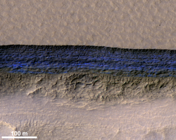
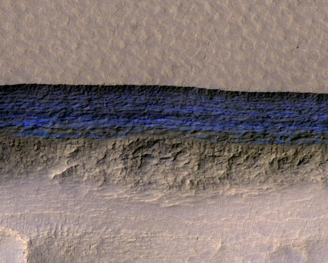
Figure 1
Click on the image for larger versionA cross-section of a thick sheet of underground ice is exposed at the steep slope (or scarp) that appears bright blue in this enhanced-color view from the High Resolution Imaging Science Experiment (HiRISE) camera on NASA's Mars Reconnaissance Orbiter.
The view covers an area about 550 yards (500 meters) wide. Figure 1 includes a 100-meter (109-yard) scale bar. North is toward the top. The upper third of the image shows level ground that is about 140 yards (130 meters) higher in elevation than the ground in the bottom third. In between, the scarp descends sharply, exposing about 260 vertical feet (80 vertical meters) of water ice.
Color is exaggerated to make differences in surface materials easier to see. The presence of exposed water ice at this site was confirmed by observation with the same orbiter's Compact Reconnaissance Imaging Spectrometer for Mars (CRISM).
In January 2018, in the journal Science, researchers reported finding and studying eight such ice-exposing scarps in the middle latitudes of Mars. The presence of vast underground ice deposits in Mars' middle latitudes was known previously. The report of unusual sites where they are exposed provides new information about their depth and layering. It also identifies potential water resources for future Mars missions and possibilities for studying Martian climate history by examining the ice layers holding a record of past climate cycles. The ice may have been deposited as snow when the tilt of Mars' rotation axis was greater than it is now.
A zoomed-out view showing more context of this site is at PIA22078. Both views are products from HiRISE observation ESP_022389_1230, made on May 7, 2011, at 56.6 degrees south latitude, 114.1 degrees east longitude.
The University of Arizona, Tucson, operates HiRISE, which was built by Ball Aerospace & Technologies Corp., Boulder, Colorado. NASA's Jet Propulsion Laboratory, a division of Caltech in Pasadena, California, manages the Mars Reconnaissance Orbiter Project for NASA's Science Mission Directorate, Washington.
 Planetary Data System


