Animation
Click on the image for larger animationOn Aug. 21, 2017, a total solar eclipse swept across the United States -- the first such eclipse in the contiguous 48 states since 1979, and the first cross-country eclipse since 1918. A partial eclipse was visible in all 50 states, and initial estimates suggest that upwards of 20 million people observed the Moon completely obscuring the Sun in the 70-mile-wide (113-kilometer-wide) path of totality. While viewing a total solar eclipse from the ground is an amazing experience, satellites orbiting Earth see the eclipse from a unique perspective.
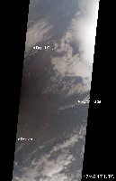
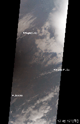
As the Moon's shadow passed through the United States, the Multi-angle Imaging SpectroRadiometer (MISR) instrument aboard NASA's Terra satellite was capturing images of eastern Wyoming and western Nebraska from its altitude of 438 miles (705 kilometers) above the surface. MISR gathers images on a strip about 249 miles (400 kilometers) wide directly below the path of the satellite. Incredibly, given that the shadow of the Moon took only 90 minutes to cross the entire United States, and Terra itself moves at a brisk 16,700 miles per hour from north to south, MISR happened to be in exactly the right place at the right time to capture totality.
From the ground, the moment of totality appears suddenly, sweeping over the sky in just a few seconds. "I was unprepared for just how dark it actually was," says Mika Tosca, a researcher who works with MISR data and who observed the eclipse in Nebraska. "The streetlights even turned on. Everything fell silent, and I swear the temperature dropped." From the vantage point of space, however, it's possible to see the entire shadow of the Moon, with the completely dark, circular umbra and the more diffuse penumbra.
MISR contains nine cameras oriented at different angles, viewing forward, downward, and backward along the flight path, resulting in an approximate seven-minute interval for all nine cameras to image a single location on Earth's surface. This animation combines these nine images into a movie showing the motion of the Moon's shadow during this seven-minute period.
In the first image, captured by the camera pointing farthest ahead of the satellite, totality has not quite begun in the area seen by MISR. From the second camera onward, totality sweeps across the image area from west to east, beginning just west of the town of Jay Em, Wyoming, and proceeding about halfway across the MISR swath to the town of Alliance, Nebraska. The motion of the lunar shadow in different pairs of images leads to estimates of the local ground speed ranging between 1,480 and 1,820 miles per hour (2,382 and 2,929 kilometers per hour). The spread in values is a measure of the uncertainty of the estimate. At this location, the predicted speed of the eclipse calculated from lunar orbital motion is about 1,658 miles per hour (2,668 kilometers per hour), which falls in the middle of the range estimated from the MISR images.
Tosca's observation that the temperature dropped during the eclipse is a well-known phenomenon. The GLOBE Observer, a phone application dedicated to citizen science and sponsored by NASA, encouraged eclipse-goers to record the local air temperature at regular intervals. Data collected by nearby observers in the path of totality show that, on average, temperatures dropped by 9.3 degrees Fahrenheit (5.2 degrees Celsius) during the eclipse. This compares to an average of 5.4 degrees Fahrenheit drop measured at several Nebraska Mesonet weather stations within the path of totality.
The decrease in the amount of sunlight reaching Earth affected more than temperatures. Areas that get a large portion of their power from solar energy were naturally concerned about shortages during the eclipse -- the state of California, though not in the path of totality, estimated that 6,000 megawatts of solar power would be lost during the eclipse.
The MISR data were captured during Terra orbit 94021. MISR data are available through the NASA Langley Research Center; for more information, go to https://eosweb.larc.nasa.gov/project/misr/misr_table. The Nebraska Mesonet data were provided by the Nebraska State Climate Office and the University of Nebraska-Lincoln. The citizen science data were provided by the GLOBE Program via NASA's GLOBE Observer project; data are available at https://datasearch.globe.gov/. MISR was built and is managed by NASA's Jet Propulsion Laboratory in Pasadena, California, for NASA's Science Mission Directorate in Washington, D.C. The Terra spacecraft is managed by NASA's Goddard Space Flight Center in Greenbelt, Maryland. The MISR data were obtained from the NASA Langley Research Center Atmospheric Science Data Center in Hampton, Virginia. JPL is a division of Caltech in Pasadena.
 Planetary Data System


