Map Projected Browse Image
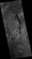
Click on the image for larger versionNASA's Mars Reconnaissance Orbiter observes many slopes in the middle latitudes of Mars showing icy flows or glaciers. The region shown here, in the south-facing slope of a crater, is unusual because the flows have bright highlights.
The color and brightness variations are likely due to surface coatings of bright dust and dark sand. There is no evidence that these flows are currently active, but they may have been active only millions of years ago. These flows may well contain ice today in their interiors, as confirmed in places by the subsurface radar experiment on MRO.
This is a stereo pair with ESP_014058_1450.
The map is projected here at a scale of 25 centimeters (9.8 inches) per pixel. [The original image scale is 27.5 centimeters (10.8 inches) per pixel (with 1 x 1 binning); objects on the order of 83 centimeters (32.7 inches) across are resolved.] North is up.
The University of Arizona, Tucson, operates HiRISE, which was built by Ball Aerospace & Technologies Corp., Boulder, Colo. NASA's Jet Propulsion Laboratory, a division of Caltech in Pasadena, California, manages the Mars Reconnaissance Orbiter Project for NASA's Science Mission Directorate, Washington.

