PDS logoPlanetary Data System
PDS Information
Find a Node - Use these links to navigate to any of the 8 publicly accessible PDS Nodes.

This bar indicates that you are within the PDS enterprise which includes 6 science discipline nodes and 2 support nodes which are overseen by the Project Management Office at NASA's Goddard Space Flight Center (GSFC). Each node is led by an expert in the subject discipline, supported by an advisory group of other practitioners of that discipline, and subject to selection and approval under a regular NASA Research Announcement.
Click here to return to the Photojournal Home Page Click here to view a list of Photojournal Image Galleries Photojournal_inner_header
Latest Images  |  Spacecraft & Technology  |  Animations  |  Space Images App  |  Feedback  |  Photojournal Search  

PIA21935: Mixtures of Sulfates in Melas Chasma
 Target Name:  Mars
 Is a satellite of:  Sol (our sun)
 Mission:  Mars Reconnaissance Orbiter (MRO)
 Spacecraft:  Mars Reconnaissance Orbiter (MRO)
 Instrument:  HiRISE
 Product Size:  2880 x 1800 pixels (w x h)
 Produced By:  University of Arizona/HiRISE-LPL
 Other  
Information: 
Other products from ESP_051129_1705
 Full-Res TIFF:  PIA21935.tif (15.56 MB)
 Full-Res JPEG:  PIA21935.jpg (1.154 MB)

Click on the image above to download a moderately sized image in JPEG format (possibly reduced in size from original)

Original Caption Released with Image:

Click here for larger version of PIA21935
Map Projected Browse Image
Click on the image for larger version

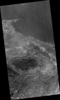
In this image from NASA's Mars Reconnaissance Orbiter, layering within the light-toned sulfate deposit is the result of different states of hydration. Some of the layers have sulfates with little water (known as monohydrated sulfates) whereas other layers have higher amounts of water (called polyhydrated sulfates). The different amounts of water within the sulfates may reflect changes in the water chemistry during deposition of the sulfates, or may have occurred after the sulfates were laid down when heat or pressure forced the water out of some layers, causing a decrease in the hydration state.

Many locations on Mars have sulfates, which are sedimentary rocks formed in water. Within Valles Marineris, the large canyon system that cuts across the planet, there are big and thick sequences of sulfates.

The CRISM instrument on MRO is crucial for telling scientists which type of sulfate is associated with each layer, because each hydration state will produce a spectrum with absorptions at specific wavelengths depending upon the amount of water contained within the sulfate.

The map is projected here at a scale of 25 centimeters (9.8 inches) per pixel. [The original image scale is 26.4 centimeters (10.4 inches) per pixel (with 1 x 1 binning); objects on the order of 79 centimeters (31.1 inches) across are resolved.] North is up.

The University of Arizona, Tucson, operates HiRISE, which was built by Ball Aerospace & Technologies Corp., Boulder, Colo. NASA's Jet Propulsion Laboratory, a division of Caltech in Pasadena, California, manages the Mars Reconnaissance Orbiter Project for NASA's Science Mission Directorate, Washington.

Image Credit:
NASA/JPL-Caltech/Univ. of Arizona

Image Addition Date:
2017-09-04