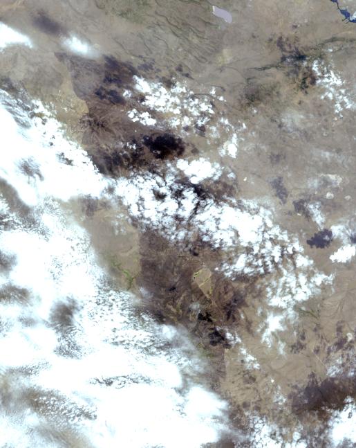
In early August 2017, the Cinder Butte fire burned 9 miles (15 kilometers) outside of the town of Riley, Oregon, and consumed more than 82 square miles (53,000 acres) of forest and brushland. The fire threatened tribal archaeological sites with strong significance to the Burns Paiute and Klamath tribes. Firefighters were able to contain the fire before it could damage the historic sites. On the image, the burned area is gray-brown, and cloud shadows are dark gray-to-black. The image was acquired Aug. 23, 2017, covers an area of 20 by 25 miles (31.5 by 39.9 kilometers), and is located at 43.5 degrees north, 119.9 degrees west.
With its 14 spectral bands from the visible to the thermal infrared wavelength region and its high spatial resolution of 15 to 90 meters (about 50 to 300 feet), ASTER images Earth to map and monitor the changing surface of our planet. ASTER is one of five Earth-observing instruments launched Dec. 18, 1999, on Terra. The instrument was built by Japan's Ministry of Economy, Trade and Industry. A joint U.S./Japan science team is responsible for validation and calibration of the instrument and data products.
The broad spectral coverage and high spectral resolution of ASTER provides scientists in numerous disciplines with critical information for surface mapping and monitoring of dynamic conditions and temporal change. Example applications are: monitoring glacial advances and retreats; monitoring potentially active volcanoes; identifying crop stress; determining cloud morphology and physical properties; wetlands evaluation; thermal pollution monitoring; coral reef degradation; surface temperature mapping of soils and geology; and measuring surface heat balance.
The U.S. science team is located at NASA's Jet Propulsion Laboratory, Pasadena, Calif. The Terra mission is part of NASA's Science Mission Directorate, Washington, D.C.
More information about ASTER is available at http://asterweb.jpl.nasa.gov/.
 Planetary Data System


