PDS logoPlanetary Data System
PDS Information
Find a Node - Use these links to navigate to any of the 8 publicly accessible PDS Nodes.

This bar indicates that you are within the PDS enterprise which includes 6 science discipline nodes and 2 support nodes which are overseen by the Project Management Office at NASA's Goddard Space Flight Center (GSFC). Each node is led by an expert in the subject discipline, supported by an advisory group of other practitioners of that discipline, and subject to selection and approval under a regular NASA Research Announcement.
Click here to return to the Photojournal Home Page Click here to view a list of Photojournal Image Galleries Photojournal_inner_header
Latest Images  |  Spacecraft & Technology  |  Animations  |  Space Images App  |  Feedback  |  Photojournal Search  

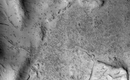
PIA21591: Secondary Craters in Bas Relief
 Target Name:  Mars
 Is a satellite of:  Sol (our sun)
 Mission:  Mars Reconnaissance Orbiter (MRO)
 Spacecraft:  Mars Reconnaissance Orbiter (MRO)
 Instrument:  HiRISE
 Product Size:  2048 x 1256 pixels (w x h)
 Produced By:  University of Arizona/HiRISE-LPL
 Other  
Information: 
Other products from ESP_049076_1845
 Full-Res TIFF:  PIA21591.tif (2.575 MB)
 Full-Res JPEG:  PIA21591.jpg (570.4 kB)

Click on the image above to download a moderately sized image in JPEG format (possibly reduced in size from original)

Original Caption Released with Image:

Click here for larger version of PIA21591
Map Projected Browse Image
Click on the image for larger version

NASA's Mars Reconnaissance Orbiter (MRO) captured this region of Mars, sprayed with secondary craters from 10-kilometer Zunil Crater to the northwest.

Secondary craters form from rocks ejected at high speed from the primary crater, which then impact the ground at sufficiently high speed to make huge numbers of much smaller craters over a large region. In this scene, however, the secondary crater ejecta has an unusual raised-relief appearance like bas-relief sculpture. How did that happen?

One idea is that the region was covered with a layer of fine-grained materials like dust or pyroclastics about 1 to 2 meters thick when the Zunil impact occurred (about a million years ago), and the ejecta served to harden or otherwise protect the fine-grained layer from later erosion by the wind.

This is a stereo pair with ESP_049564_1845.

The map is projected here at a scale of 50 centimeters (19.7 inches) per pixel. [The original image scale is 55 centimeters (21.7 inches) per pixel (with 2 x 2 binning); objects on the order of 165 centimeters (65 inches) across are resolved.] North is up

The University of Arizona, Tucson, operates HiRISE, which was built by Ball Aerospace & Technologies Corp., Boulder, Colo. NASA's Jet Propulsion Laboratory, a division of Caltech in Pasadena, California, manages the Mars Reconnaissance Orbiter Project for NASA's Science Mission Directorate, Washington.

Image Credit:
NASA/JPL-Caltech/Univ. of Arizona

Image Addition Date:
2017-04-17