Map Projected Browse Image
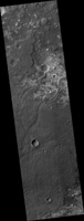
Click on the image for larger versionThis image shows a transition from depressed to inverted channels in the Gorgonum Basin. In the darker terrain, there are two channels that display depressed topography. As these two channels cross into the underlying brighter terrain, the channels now stand above the surrounding area, indicating they are inverted in topography.
This change from depressed to inverted topography is the result of what is called "differential erosion." The channel may contain hardened sediments or have cements that make it more resistant to erosion relative to the darker terrain that once flowed through it. As a result, erosion has removed the less resistant upper darker terrain, leaving behind the more resistant channel standing above the underlying bright terrain.
The University of Arizona, Tucson, operates HiRISE, which was built by Ball Aerospace & Technologies Corp., Boulder, Colo. NASA's Jet Propulsion Laboratory, a division of the California Institute of Technology in Pasadena, manages the Mars Reconnaissance Orbiter Project for NASA's Science Mission Directorate, Washington.

