View the animation here
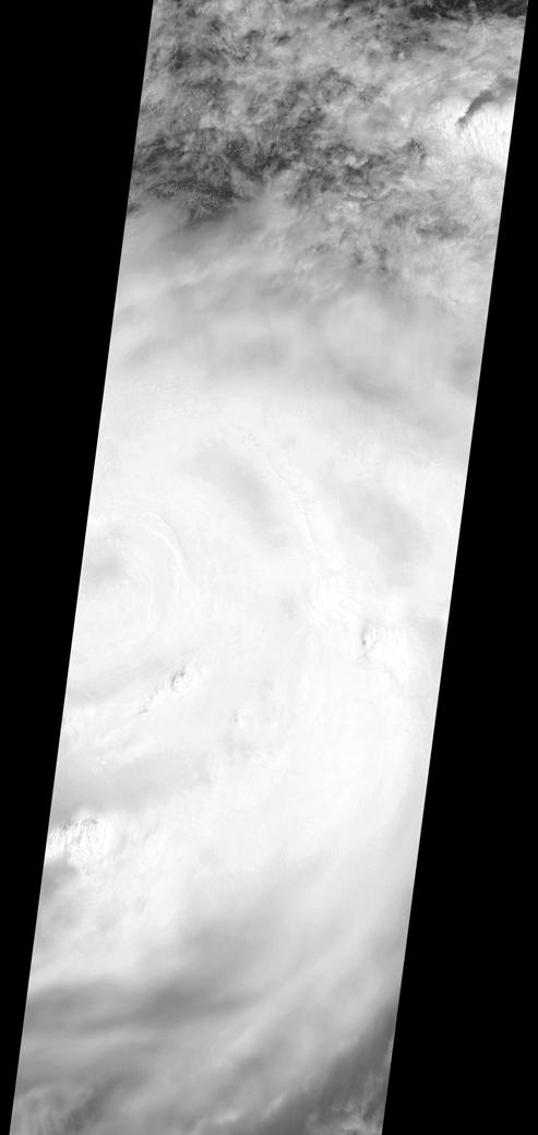
On the morning of October 4, 2016, Hurricane Matthew passed over the island nation of Haiti. A Category 4 storm, it made landfall around 7 a.m. local time (5 a.m. PDT/8 a.m. EDT) with sustained winds over 145 mph. This is the strongest hurricane to hit Haiti in over 50 years.
On October 4, at 10:30 a.m. local time (8:30 a.m. PDT/11:30 a.m. EDT), the Multi-angle Imaging SpectroRadiometer (MISR) instrument aboard NASA's Terra satellite passed over Hurricane Matthew. This animation was made from images taken by MISR's downward-pointing (nadir) camera is 235 miles (378 kilometers) across, which is much narrower than the massive diameter of Matthew, so only the hurricane's eye and a portion of the storm's right side are visible. Haiti is completely obscured by Matthew's clouds, but part of the Bahamas is visible to the north. Several hot towers are visible within the central part of the storm, and another at the top right of the image. Hot towers are enormous thunderheads that punch through the tropopause (the boundary between the lowest layer of the atmosphere, the troposphere, and the next level, the stratosphere). The rugged topography of Haiti causes uplift within the storm, generating these hot towers and fueling even more rain than Matthew would otherwise dump on the country.
MISR has nine cameras fixed at different angles, which capture images of the same point on the ground within about seven minutes. This animation was created by blending images from these nine cameras. The change in angle between the images causes a much larger motion from south to north than actually exists, but the rotation of the storm is real motion. From this animation, you can get an idea of the incredible height of the hot towers, especially the one to the upper right. The counter-clockwise rotation of Matthew around its closed (cloudy) eye is also visible.
These data were acquired during Terra orbit 89345. Other MISR data are available through the NASA Langley Research Center.
For more information, visit http://eosweb.larc.nasa.gov/project/misr/misr_table.
MISR was built and is managed by NASA's Jet Propulsion Laboratory, Pasadena, California, for NASA's Science Mission Directorate, Washington, D.C. The Terra spacecraft is managed by NASA's Goddard Space Flight Center, Greenbelt, Maryland. The MISR data were obtained from the NASA Langley Research Center Atmospheric Science Data Center, Hampton, Virginia. JPL is a division of Caltech in Pasadena.
