PDS logoPlanetary Data System
PDS Information
Find a Node - Use these links to navigate to any of the 8 publicly accessible PDS Nodes.

This bar indicates that you are within the PDS enterprise which includes 6 science discipline nodes and 2 support nodes which are overseen by the Project Management Office at NASA's Goddard Space Flight Center (GSFC). Each node is led by an expert in the subject discipline, supported by an advisory group of other practitioners of that discipline, and subject to selection and approval under a regular NASA Research Announcement.
Click here to return to the Photojournal Home Page Click here to view a list of Photojournal Image Galleries Photojournal_inner_header
Latest Images  |  Spacecraft & Technology  |  Animations  |  Space Images App  |  Feedback  |  Photojournal Search  

PIA20837: Outflow Stream from Relatively Recent Martian Lake
 Target Name:  Mars
 Is a satellite of:  Sol (our sun)
 Mission:  Mars Reconnaissance Orbiter (MRO)
 Spacecraft:  Mars Reconnaissance Orbiter (MRO)
 Instrument:  CTX
 Product Size:  1934 x 2471 pixels (w x h)
 Produced By:  Arizona State University
 Full-Res TIFF:  PIA20837.tif (4.784 MB)
 Full-Res JPEG:  PIA20837.jpg (973.5 kB)

Click on the image above to download a moderately sized image in JPEG format (possibly reduced in size from original)

Original Caption Released with Image:

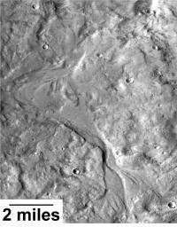
Streamlined forms and channel bars in this Martian valley resulted from the outflow of a lake hundreds of millions years more recently than an era of Martian lakes previously confirmed, according to 2016 findings.

This excerpt from an image taken by the Context Camera on NASA's Mars Reconnaissance Orbiter covers an area about 8 miles (13 kilometers) wide in the northern Arabia Terra region of Mars. The flow direction was generally northward (toward the top of this image). The channel breached a water-filled basin identified as "B" in a hydrologic-modeling map at PIA20839 and flowed toward a larger basin, informally called "Heart Lake," about 50 miles (80 kilometers) to the northwest.

Researchers estimate this stream and the lakes it linked held water at some time in the range of 2 billion to 3 billion years ago. That is several hundred million to about 1 billion years later than better-known ancient lake environments on Mars, such as those documented by NASA's Curiosity rover mission. The later wet period came after it is generally thought that most of Mars' original atmosphere had been lost and most of the remaining water on the planet had frozen. Seasonal melting may have fed this stream.

This is a portion of Context Camera image B18_016815_2151. The camera was built by and is operated by Malin Space Science Systems, San Diego. NASA's Jet Propulsion Laboratory, a division of Caltech in Pasadena, California, manages the Mars Reconnaissance Orbiter Project for NASA's Science Mission Directorate, Washington.

Image Credit:
NASA/JPL-Caltech/MSSS

Image Addition Date:
2016-09-15