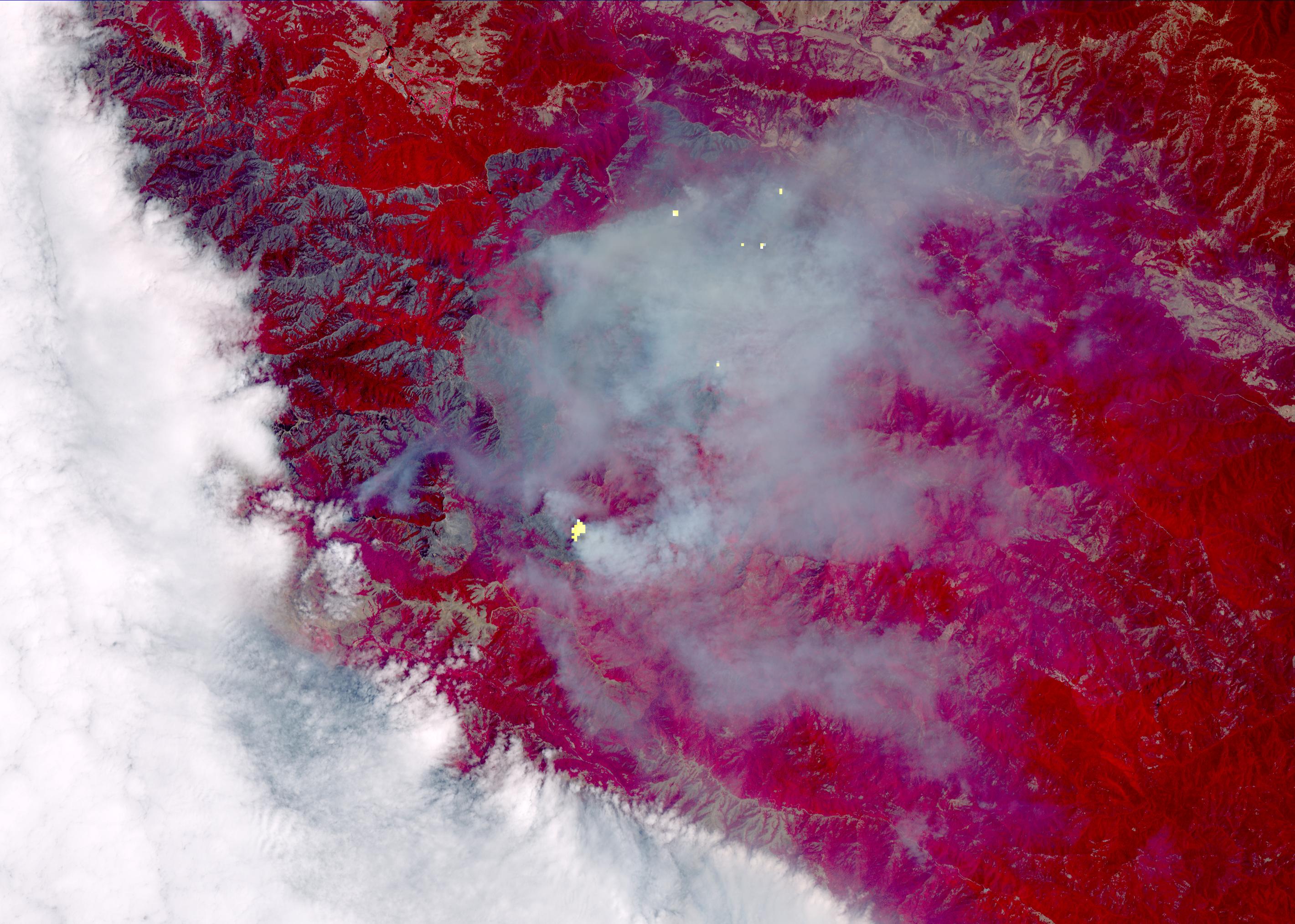
The Soberanes fire, in Central California near Big Sur, had grown to more than 67,000 acres when the Advanced Spaceborne Thermal Emission and Reflection Radiometer (ASTER) instrument on NASA's Terra spacecraft captured this image on Aug. 6, 2016. More than 4,800 personnel are battling the blaze, which is now 50 percent contained. The fire has destroyed 57 homes and 11 outbuildings and caused one fatality. Evacuation orders are still in effect for a number of nearby communities. The fire was caused by an illegal unattended campfire. Vegetation is depicted in red colors; burned areas are dark grey; clouds are white; smoke and ash are light grey. Yellow indicates active fires, detected on ASTER's thermal infrared channels. The image covers an area of 19 by 26 miles (30 by 42 kilometers), and is located at 36.4 degrees north, 121.8 degrees west.
With its 14 spectral bands from the visible to the thermal infrared wavelength region and its high spatial resolution of 15 to 90 meters (about
50 to 300 feet), ASTER images Earth to map and monitor the changing surface of our planet. ASTER is one of five Earth-observing
instruments launched Dec. 18, 1999, on Terra. The instrument was built by Japan's Ministry of Economy, Trade and Industry. A joint
U.S./Japan science team is responsible for validation and calibration of the instrument and data products.
The broad spectral coverage and high spectral resolution of ASTER provides scientists in numerous disciplines with critical information for
surface mapping and monitoring of dynamic conditions and temporal change. Example applications are: monitoring glacial advances and
retreats; monitoring potentially active volcanoes; identifying crop stress; determining cloud morphology and physical properties; wetlands
evaluation; thermal pollution monitoring; coral reef degradation; surface temperature mapping of soils and geology; and measuring surface
heat balance.
The U.S. science team is located at NASA's Jet Propulsion Laboratory, Pasadena, Calif. The Terra mission is part of NASA's Science
Mission Directorate, Washington, D.C.
More information about ASTER is available at http://asterweb.jpl.nasa.gov/.
