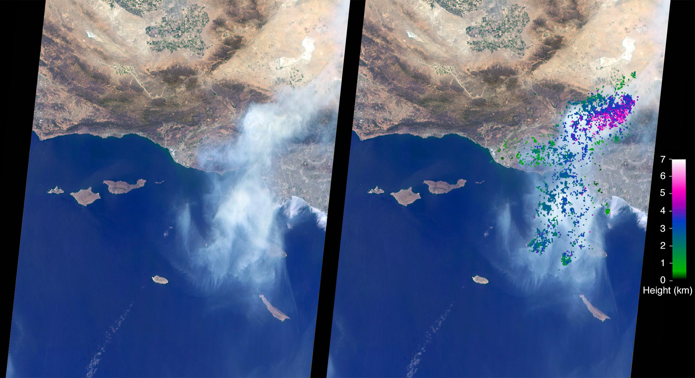
The Sand Fire in the Santa Clarita Valley area of Southern California erupted on Friday, July 22, 2016, and rapidly grew to almost 39,000 acres (60 square miles, or 160 square kilometers). Thousands of residents were evacuated, and the fire claimed the life of one person. The Multi-angle Imaging SpectroRadiometer (MISR) instrument aboard NASA's Terra satellite passed over the region on July 23 around 11:50 a.m. PDT. At left is an image acquired by MISR's 60-degree forward-viewing camera. The oblique view angle makes the smoke more apparent than it would be in a more conventional vertical view. This cropped image is about 185 miles (300 kilometers) wide. Smoke from the Sand Fire is visible on the right-hand side of the image.
Stereoscopic analysis of MISR's multiple camera angles is used to compute the height of the smoke plume from the Sand Fire. In the right-hand image, these heights are superimposed on the underlying image. The color scale shows that the plume extends up to about 4 miles (6 kilometers) above its source in Santa Clarita, but rapidly diminishes in height as winds push it to the southwest. The data compare well with a pilot report issued at Los Angeles International Airport on the evening of July 22, which reported smoke at 15,000-18,000 feet altitude (4.5 to 5.5 kilometers). Air quality warnings were issued for the San Fernando Valley and the western portion of Los Angeles due to this low-hanging smoke. However, data from air quality monitoring instruments seem to indicate that the smoke did not actually reach the ground.
These data were captured during Terra orbit 88284. The stereoscopic analysis was performed using the MISR INteractive eXplorer (MINX) software tool, which is publicly available through the Open Channel Foundation at http://www.openchannelsoftware.com/projects/MINX. A database of previously digitized plumes is available from the MISR Plume Height Project at http://misr.jpl.nasa.gov/getData/accessData/MISRPlumeHeight/. MISR was built and is managed by NASA's Jet Propulsion Laboratory, Pasadena, California, for NASA's Science Mission Directorate, Washington, D.C. The Terra spacecraft is managed by NASA's Goddard Space Flight Center, Greenbelt, Maryland. The MISR data were obtained from the NASA Langley Research Center Atmospheric Science Data Center, Hampton, Virginia. JPL is a division of the California Institute of Technology in Pasadena.
 Planetary Data System


