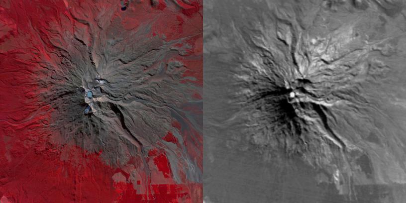
Mount Ruapehu Volcano in New Zealand has been on a level 1 volcanic alert for some time, indicating minor volcanic unrest. Since late April 2016, the temperature of the lake in the volcano's crater has risen from 68 to 113 degrees Fahrenheit (20 to 45 degrees Celsius). Authorities have raised the volcanic alert level to level 2, indicating "moderate to heightened volcanic unrest." These images were acquired April 20, 2016 by the Advanced Spaceborne Thermal Emission and Reflection Radiometer (ASTER) instrument on NASA's Terra spacecraft. The left image depicts vegetation in red, and the crater lake is light blue. The right thermal infrared image shows hotter areas in white. The images cover an area of 13 by 13 miles (21 by 21 kilometers), and are located at 39.3 degrees south, 175.6 degrees east.
With its 14 spectral bands from the visible to the thermal infrared wavelength region and its high spatial resolution of 15 to 90 meters (about 50 to 300 feet), ASTER images Earth to map and monitor the changing surface of our planet. ASTER is one of five Earth-observing instruments launched Dec. 18, 1999, on Terra. The instrument was built by Japan's Ministry of Economy, Trade and Industry. A joint U.S./Japan science team is responsible for validation and calibration of the instrument and data products.
The broad spectral coverage and high spectral resolution of ASTER provides scientists in numerous disciplines with critical information for surface mapping and monitoring of dynamic conditions and temporal change. Example applications are: monitoring glacial advances and retreats; monitoring potentially active volcanoes; identifying crop stress; determining cloud morphology and physical properties; wetlands evaluation; thermal pollution monitoring; coral reef degradation; surface temperature mapping of soils and geology; and measuring surface heat balance.
The U.S. science team is located at NASA's Jet Propulsion Laboratory, Pasadena, Calif. The Terra mission is part of NASA's Science Mission Directorate, Washington, D.C.
More information about ASTER is available at http://asterweb.jpl.nasa.gov/.
 Planetary Data System


