Devastating wildfires in Alberta Province, Canada, near the city of Fort McMurray began on May 1, 2016. These fires had destroyed at least 1,600 homes and other structures as of May 9 and resulted in massive evacuations throughout the city. During the start of the fire, northern Alberta experienced record-setting high temperatures, which later climbed to above 91 degrees Fahrenheit. Dry conditions associated with the current El Niño and gusty winds were major contributors to the growth of these enormous fires.
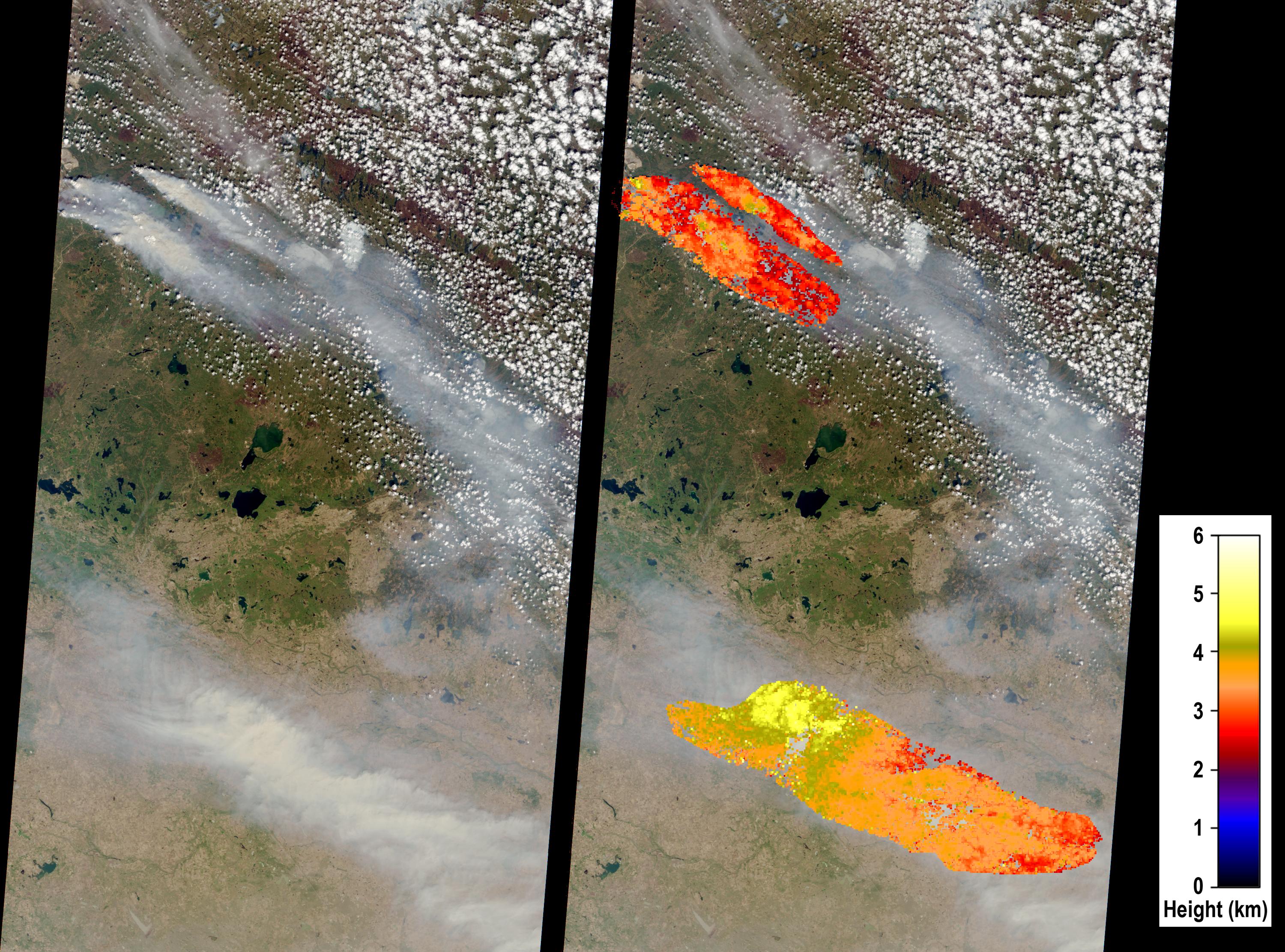
The Multi-angle Imaging SpectroRadiometer (MISR) instrument aboard NASA's Terra satellite captured this view of the area on May 6, 2016, from its nadir (vertical-viewing camera). The width of the MISR nadir camera swath is 235 miles (378 kilometers). Fort McMurray is located at the upper left edge of the image, and several large smoke plumes originating near the city are visible. Computerized analysis of the stereoscopic imagery acquired by MISR's multiple cameras is used to determine the height of the smoke. In the right-hand image, the retrieved height field is superimposed upon the nadir camera view. The analysis reveals that on this date, the large fires injected smoke into the atmosphere 2 to 2.5 miles (3 to 4 kilometers) above sea level (ASL). Embedded with the plume, and near the fire source, are several "pyrocumulus clouds." These are convective clouds that form as a result of intense thermal heating emanating from surface wildfires. The intense heating drives convection within the smoke plume. At the bottom of the image is a transported smoke cloud with heights exceeding 3.1 miles (5 kilometers) ASL. Smoke at these high altitudes can be transported long distances and therefore has important climate implications that can extend far from the fire itself. Smoke near the surface has adverse impacts on human health.
These data were acquired during Terra orbit 87148. The stereoscopic analysis was performed using the MISR INteractive eXplorer (MINX) software tool, which is publicly available through the Open Channel Foundation at http://www.openchannelsoftware.com/projects/MINX. A database of previously digitized plumes is available from the MISR Plume Height Project at http://misr.jpl.nasa.gov/getData/accessData/MISRPlumeHeight/.
MISR was built and is managed by NASA's Jet Propulsion Laboratory, Pasadena, California, for NASA's Science Mission Directorate, Washington, D.C. The Terra spacecraft is managed by NASA's Goddard Space Flight Center, Greenbelt, Maryland. The MISR data were obtained from the NASA Langley Research Center Atmospheric Science Data Center, Hampton, Virginia. JPL is a division of the California Institute of Technology in Pasadena.
